Mesilla Park, New Mexico
| Mesilla Park | |
|---|---|
| Neighborhood | |
 Mesilla Park  Mesilla Park Location within the state of New Mexico | |
| Coordinates: 32°16′33″N 106°46′00″W / 32.27583°N 106.76667°WCoordinates: 32°16′33″N 106°46′00″W / 32.27583°N 106.76667°W | |
| Country | United States |
| State | New Mexico |
| County | Doña Ana |
| Elevation | 3,878 ft (1,182 m) |
| Time zone | Mountain (MST) (UTC-7) |
| • Summer (DST) | MDT (UTC-6) |
| ZIP codes | 88047[1] |
| Area code(s) | 575 |
| GNIS feature ID | 899786[2] |
Mesilla Park is a neighborhood located on the south side of Las Cruces, New Mexico, United States. Residents of Mesilla founded the community through a land company in 1887, shortly after Las Cruces became the county seat of Doña Ana County. At the time, it was an independent settlement, though it was eventually annexed by Las Cruces. The neighborhood adjoins University Park, the site of New Mexico State University, and it grew after the university was founded in 1889. Mesilla Park still has its own post office with ZIP code 88047, which opened in 1892.[1][3][4]
References
- 1 2 United States Postal Service. "USPS - Look Up a ZIP Code". Retrieved November 30, 2014.
- ↑ "Mesilla Park". Geographic Names Information System. United States Geological Survey.
- ↑ "Postmaster Finder - Post Offices by ZIP Code". United States Postal Service. Retrieved November 30, 2014.
- ↑ Julyan, Robert (August 26, 1996). The Place Names of New Mexico. UNM Press. p. 227. ISBN 9780826351142.
Municipalities and communities of Doña Ana County, New Mexico, United States | ||
|---|---|---|
| Cities | 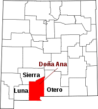 | |
| Town | ||
| Village | ||
| CDPs | ||
| Ghost towns | ||
This article is issued from Wikipedia - version of the 8/7/2016. The text is available under the Creative Commons Attribution/Share Alike but additional terms may apply for the media files.