Mesa Verde region

The Mesa Verde Region is a portion of the Colorado Plateau in the United States that extends through parts of New Mexico, Colorado and Utah. It is bounded by the San Juan River to the south, the Piedra River to the east, the San Juan Mountains to the north and the Colorado River to the west.[1]
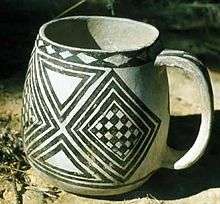
The Crow Canyon Archaeological Center near Cortez, Colorado, in the heart of the Mesa Verde, has been conducting research in the region since 1982.[2] Although the Mesa Verde National Park contains the largest and best known ruins of the Pueblo peoples, there are many other community centers in the central Mesa Verde region dating to the period between 1050 and 1290 AD. This is a huge area covering over 150,000 square miles (390,000 km2).[3] Over 130 centers containing fifty or more residential structures have been identified in the central region, many of which have yet to be examined in any detail.[4]
A small portion of the Mesa Verde to the southeast of Cortez, Colorado contains the Mesa Verde National Park, which protects almost 5,000 archaeological sites, including 600 cliff dwellings of the Ancient Pueblo Peoples who lived in the area between 600 and 1300 AD.[5] Other parks in the Mesa Verde from west to east include the Glen Canyon National Recreation Area, Natural Bridges National Monument, Hovenweep National Monument, Yucca House National Monument and Aztec Ruins National Monument.[6]
References
Citations
- ↑ Peoples of the Mesa Verde Region.
- ↑ Varien 2002, p. 3.
- ↑ Varien 2002, p. 10.
- ↑ Varien 2002, p. 11.
- ↑ Mesa Verde National Park.
- ↑ Find A Park.
Sources
- "Find A Park". National Park Service. Retrieved 2012-08-26.
- "Mesa Verde National Park, Colorado". National Park Service. Retrieved 2012-08-26.
- "Peoples of the Mesa Verde Region". Crow Canyon Archaeological Center. Retrieved 2012-08-26.
- Varien, Mark (2002-10-16). Seeking The Center Place: Archaeology and Ancient Communities in the Mesa Verde Region. University of Utah Press. ISBN 978-0-87480-735-6. Retrieved 2012-08-26.