Memphis, Michigan
| Memphis, Michigan | |
|---|---|
| City | |
| Motto: A Pleasant Place to Live | |
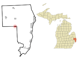 Location of Memphis, Michigan | |
| Coordinates: 42°53′47″N 82°46′15″W / 42.89639°N 82.77083°W | |
| Country | United States |
| State | Michigan |
| Counties | Macomb, St. Clair |
| Area[1] | |
| • Total | 1.15 sq mi (2.98 km2) |
| • Land | 1.12 sq mi (2.90 km2) |
| • Water | 0.03 sq mi (0.08 km2) |
| Elevation | 755 ft (230 m) |
| Population (2010)[2] | |
| • Total | 1,183 |
| • Estimate (2012[3]) | 1,179 |
| • Density | 1,056.3/sq mi (407.8/km2) |
| Time zone | Eastern (EST) (UTC-5) |
| • Summer (DST) | EDT (UTC-4) |
| Area code(s) | 810 |
| FIPS code | 26-52960[4] |
| GNIS feature ID | 1624727[5] |
Memphis is a city on the line between Macomb and St. Clair counties in the U.S. state of Michigan. The population was 1,183 at the 2010 census.
Geography
According to the United States Census Bureau, the city has a total area of 1.15 square miles (2.98 km2), of which 1.12 square miles (2.90 km2) is land and 0.03 square miles (0.08 km2) is water.[1] The city is evenly divided between Macomb and St. Clair counties. The Belle River passes through the city. Memphis is also known for its slogan, "A Pleasant Place To Live."
Demographics
| Historical population | |||
|---|---|---|---|
| Census | Pop. | %± | |
| 1870 | 385 | — | |
| 1880 | 579 | 50.4% | |
| 1890 | 588 | 1.6% | |
| 1900 | 586 | −0.3% | |
| 1910 | 557 | −4.9% | |
| 1920 | 452 | −18.9% | |
| 1930 | 574 | 27.0% | |
| 1940 | 630 | 9.8% | |
| 1950 | 80 | −87.3% | |
| 1960 | 996 | 1,145.0% | |
| 1970 | 1,121 | 12.6% | |
| 1980 | 1,171 | 4.5% | |
| 1990 | 1,221 | 4.3% | |
| 2000 | 1,129 | −7.5% | |
| 2010 | 1,183 | 4.8% | |
| Est. 2015 | 1,182 | [6] | −0.1% |
As of 2000 the median income for a household in the city was $41,705, and the median income for a family was $52,679. Males had a median income of $41,932 versus $27,019 for females. The per capita income for the city was $19,983. About 7.8% of families and 10.0% of the population were below the poverty line, including 10.5% of those under age 18 and 15.9% of those age 65 or over.
2010 census
As of the census[2] of 2010, there were 1,183 people, 474 households, and 320 families residing in the city. The population density was 1,056.3 inhabitants per square mile (407.8/km2). There were 514 housing units at an average density of 458.9 per square mile (177.2/km2). The racial makeup of the city was 97.6% White, 0.8% African American, 0.3% Native American, 0.5% from other races, and 0.8% from two or more races. Hispanic or Latino of any race were 2.1% of the population.
There were 474 households of which 34.8% had children under the age of 18 living with them, 49.8% were married couples living together, 13.9% had a female householder with no husband present, 3.8% had a male householder with no wife present, and 32.5% were non-families. 27.8% of all households were made up of individuals and 11.9% had someone living alone who was 65 years of age or older. The average household size was 2.47 and the average family size was 3.02.
The median age in the city was 39.4 years. 24.3% of residents were under the age of 18; 7.9% were between the ages of 18 and 24; 26% were from 25 to 44; 27.9% were from 45 to 64; and 13.8% were 65 years of age or older. The gender makeup of the city was 47.8% male and 52.2% female.
Public schools
The Memphis Community School District has an elementary, junior high, and high school. Its sports teams are nicknamed the Yellowjackets.
Additional information
Memphis was established in 1835 and named after Memphis, Egypt, "the City on the Nile." It is located on a bluff overlooking the Belle River.
Memphis has a landmark called "The Thing", which has a state of Michigan historical marker noting Memphis as the home of the first automobile. The marker reads as follows: "Thomas Clegg (1863-1939) and his English-born father, John, built "The Thing," the first recorded self-propelled vehicle in Michigan (and perhaps the country) in 1884-85. The Thing, driven by a single cylinder steam engine with a tubular boiler carried in the rear, seated four. The vehicle was built in the John Clegg & Son machine shop here in Memphis. It ran about 500 miles (800 km) before Clegg dismantled it and sold the engine to a creamery. The shop was razed in 1936, just a short time before Henry Ford offered to buy it for Greenfield Village." It is located on Bordman Road, east of the village limits of Memphis.[8][9]
References
- 1 2 "US Gazetteer files 2010". United States Census Bureau. Retrieved 2012-11-25.
- 1 2 "American FactFinder". United States Census Bureau. Retrieved 2012-11-25.
- ↑ "Population Estimates". United States Census Bureau. Retrieved 2013-06-03.
- ↑ "American FactFinder". United States Census Bureau. Retrieved 2008-01-31.
- ↑ "US Board on Geographic Names". United States Geological Survey. 2007-10-25. Retrieved 2008-01-31.
- ↑ "Annual Estimates of the Resident Population for Incorporated Places: April 1, 2010 to July 1, 2015". Retrieved July 2, 2016.
- ↑ "Census of Population and Housing". Census.gov. Retrieved June 4, 2015.
- ↑ Historical Markers, Macomb County Historical Commission
- ↑ Michigan Historical Marker: "The Thing"
External links
- City of Memphis Official Website
- Memphis Community School District
- NEMC-TV6 City of Memphis Public-access television Channel website
Municipalities and communities of Macomb County, Michigan, United States | ||
|---|---|---|
| Cities | 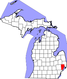 | |
| Villages | ||
| Charter townships | ||
| General law townships | ||
| Unincorporated community |
| |
| Footnotes | ‡This populated place also has portions in an adjacent county or counties | |
Municipalities and communities of St. Clair County, Michigan, United States | ||
|---|---|---|
| Cities |  | |
| Villages | ||
| Charter townships | ||
| General law townships | ||
| CDP | ||
| Other unincorporated communities |
| |
| Footnotes | ‡This populated place also has portions in an adjacent county or counties | |
Coordinates: 42°53′47″N 82°46′08″W / 42.89639°N 82.76889°W