Manvel, North Dakota
| Manvel, North Dakota | |
|---|---|
| City | |
|
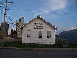
The community museum in Manvel | |
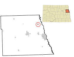 Location of Manvel, North Dakota | |
| Coordinates: 48°4′19″N 97°10′39″W / 48.07194°N 97.17750°WCoordinates: 48°4′19″N 97°10′39″W / 48.07194°N 97.17750°W | |
| Country | United States |
| State | North Dakota |
| County | Grand Forks |
| Metro | Greater Grand Forks |
| Founded | 1881 |
| Area[1] | |
| • Total | 0.29 sq mi (0.75 km2) |
| • Land | 0.29 sq mi (0.75 km2) |
| • Water | 0 sq mi (0 km2) |
| Elevation | 820 ft (250 m) |
| Population (2010)[2] | |
| • Total | 360 |
| • Estimate (2015)[3] | 375 |
| • Density | 1,241.4/sq mi (479.3/km2) |
| Time zone | Central (CST) (UTC-6) |
| • Summer (DST) | CDT (UTC-5) |
| ZIP code | 58256 |
| Area code(s) | 701 |
| FIPS code | 38-50420 |
| GNIS feature ID | 1030090[4] |
Manvel is a city in Grand Forks County, North Dakota, United States. It sits on the banks of the Turtle River. It is part of the "Grand Forks, ND-MN Metropolitan Statistical Area" or "Greater Grand Forks". The population was 360 at the 2010 census.[5] Manvel was founded in 1881.
History
The first settlement at Manvel was made in the 1860s on a stagecoach route.[6] Manvel was laid out in 1881 when the railroad was extended to that point.[7] The city was named for a Great Northern Railway passenger agent named Allen A. Manvel.[8] A post office has been in operation at Manvel since 1882.[9]
Geography
Manvel is located at 48°4′19″N 97°10′39″W / 48.07194°N 97.17750°W (48.071820, -97.177482).[10]
According to the United States Census Bureau, the city has a total area of 0.29 square miles (0.75 km2), all of it land.[1]
Demographics
| Historical population | |||
|---|---|---|---|
| Census | Pop. | %± | |
| 1930 | 183 | — | |
| 1940 | 209 | 14.2% | |
| 1950 | 278 | 33.0% | |
| 1960 | 313 | 12.6% | |
| 1970 | 265 | −15.3% | |
| 1980 | 308 | 16.2% | |
| 1990 | 333 | 8.1% | |
| 2000 | 370 | 11.1% | |
| 2010 | 360 | −2.7% | |
| Est. 2015 | 375 | [11] | 4.2% |
| U.S. Decennial Census[12] 2015 Estimate[3] | |||
2010 census
As of the census[2] of 2010, there were 360 people, 137 households, and 102 families residing in the city. The population density was 1,241.4 inhabitants per square mile (479.3/km2). There were 149 housing units at an average density of 513.8 per square mile (198.4/km2). The racial makeup of the city was 99.2% White, 0.3% Native American, and 0.6% from two or more races. Hispanic or Latino of any race were 0.8% of the population.
There were 137 households of which 39.4% had children under the age of 18 living with them, 64.2% were married couples living together, 7.3% had a female householder with no husband present, 2.9% had a male householder with no wife present, and 25.5% were non-families. 22.6% of all households were made up of individuals and 7.2% had someone living alone who was 65 years of age or older. The average household size was 2.63 and the average family size was 3.12.
The median age in the city was 37.1 years. 28.1% of residents were under the age of 18; 6.9% were between the ages of 18 and 24; 27.8% were from 25 to 44; 28.1% were from 45 to 64; and 9.2% were 65 years of age or older. The gender makeup of the city was 51.4% male and 48.6% female.
2000 census
As of the census of 2000, there were 370 people, 141 households, and 100 families residing in the city. The population density was 1,254.8 people per square mile (492.6/km²). There were 144 housing units at an average density of 488.4 per square mile (191.7/km²). The racial makeup of the city was 96.22% White, 0.81% African American, 1.35% Native American, 0.81% from other races, and 0.81% from two or more races. Hispanic or Latino of any race were 1.35% of the population.
There were 141 households out of which 34.0% had children under the age of 18 living with them, 59.6% were married couples living together, 9.2% had a female householder with no husband present, and 28.4% were non-families. 22.0% of all households were made up of individuals and 10.6% had someone living alone who was 65 years of age or older. The average household size was 2.62 and the average family size was 3.14.
In the city the population was spread out with 28.6% under the age of 18, 6.2% from 18 to 24, 30.5% from 25 to 44, 26.2% from 45 to 64, and 8.4% who were 65 years of age or older. The median age was 35 years. For every 100 females there were 113.9 males. For every 100 females age 18 and over, there were 104.7 males.
The median income for a household in the city was $42,083, and the median income for a family was $48,333. Males had a median income of $34,500 versus $22,361 for females. The per capita income for the city was $17,502. About 1.0% of families and 4.3% of the population were below the poverty line, including 5.3% of those under age 18 and 7.1% of those age 65 or over.
References
- 1 2 "US Gazetteer files 2010". United States Census Bureau. Retrieved 2012-06-14.
- 1 2 "American FactFinder". United States Census Bureau. Retrieved 2012-06-14.
- 1 2 "Population Estimates". United States Census Bureau. Retrieved June 25, 2016.
- ↑ "US Board on Geographic Names". United States Geological Survey. 2007-10-25. Retrieved 2008-01-31.
- ↑ "2010 Census Redistricting Data (Public Law 94-171) Summary File". American FactFinder. United States Census Bureau. Retrieved 2 May 2011.
- ↑ Federal Writers' Project (1938). North Dakota, a Guide to the Northern Prairie State. WPA. p. 190. ISBN 978-1-62376-033-5.
- ↑ North Dakota: Counties, Towns and People. Watchmaker Publishing, Ltd. 2008. p. 114. ISBN 978-1-60386-115-1.
- ↑ "Feature Detail Report for: Manvel". Geographic Names Information System (GNIS). United States Geological Survey. Retrieved 25 October 2011.
- ↑ "Grand Forks County". Jim Forte Postal History. Retrieved 24 October 2015.
- ↑ "US Gazetteer files: 2010, 2000, and 1990". United States Census Bureau. 2011-02-12. Retrieved 2011-04-23.
- ↑ "Annual Estimates of the Resident Population for Incorporated Places: April 1, 2010 to July 1, 2015". Retrieved July 2, 2016.
- ↑ United States Census Bureau. "Census of Population and Housing". Retrieved July 20, 2013.
External links
- Manvel : from trails to tribute : Manvel centennial 1882-1982,June 25-26-27, Manvel, North Dakota from the Digital Horizons website
Municipalities and communities of Grand Forks County, North Dakota, United States | ||
|---|---|---|
| Cities | 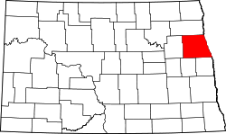 | |
| Townships |
| |
| CDP |
| |
| Unincorporated communities |
| |
| Footnotes | ‡This populated place also has portions in an adjacent county or counties | |
| Counties | ||
|---|---|---|
| Main cities | ||
| Surrounding areas | ||
† - county seat | ||