Manson, Washington
| Manson, Washington | |
|---|---|
| Census-designated place | |
|
Aerial view of Manson | |
 Manson | |
| Coordinates: 47°53′06″N 120°09′25″W / 47.88500°N 120.15694°WCoordinates: 47°53′06″N 120°09′25″W / 47.88500°N 120.15694°W | |
| Country | United States |
| State | Washington |
| County | Chelan |
| Area | |
| • Total | 1.25 sq mi (3.25 km2) |
| • Land | 1.25 sq mi (3.25 km2) |
| • Water | 0.0 sq mi (0.0 km2) |
| Elevation | 1,140 ft (350 m) |
| Population (2010) | |
| • Total | 1,468 |
| • Density | 1,171/sq mi (452.3/km2) |
| Time zone | Pacific (PST) (UTC-8) |
| • Summer (DST) | PDT (UTC-7) |
| ZIP code | 98831 |
| Area code(s) | 509 |
| GNIS feature ID | 1522682[1] |
| FIPS code | 53-42835 |
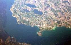
Manson is an unincorporated community and census-designated place in Chelan County in the U.S. state of Washington. It was named in 1912 for Manson F. Backus, president of the Lake Chelan Land Company.[2] Manson is located in the north-central portion of the state on the north shore of Lake Chelan, approximately 7 miles (11 km) northwest of the city of Chelan.
Manson is part of the Wenatchee–East Wenatchee Metropolitan Statistical Area.
The USPS ZIP code for Manson is 98831. As of the 2010 census, the population in the Manson was 1,468.[3] 2010 was the first year that Manson was tracked by the census bureau.
References
- ↑ U.S. Geological Survey Geographic Names Information System: Manson, Washington
- ↑ Meany, Edmond S. (1923). Origin of Washington geographic names. Seattle: University of Washington Press. p. 158.
- ↑ "Geographic Identifiers: 2010 Demographic Profile Data (G001): Manson CDP, Washington". U.S. Census Bureau, American Factfinder. Retrieved August 26, 2015.
External links
- Lake Chelan Chamber of Commerce
- Manson Village Tribune, online newspaper
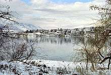
View of Manson from Wapato Point
Municipalities and communities of Chelan County, Washington, United States | ||
|---|---|---|
| Cities | 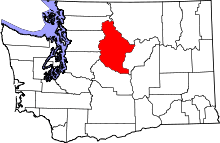 | |
| CDPs | ||
| Other unincorporated communities | ||
| Indian reservation | ||
| Ghost towns | ||
| Footnotes | ‡This populated place also has portions in an adjacent county or counties | |
This article is issued from Wikipedia - version of the 10/1/2016. The text is available under the Creative Commons Attribution/Share Alike but additional terms may apply for the media files.