Leavenworth, Washington
| Leavenworth, Washington | |
|---|---|
| City | |
|
Leavenworth's main street reflects its modelling on a Bavarian village | |
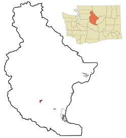 Location of Leavenworth, Washington | |
| Coordinates: 47°35′47″N 120°39′55″W / 47.59639°N 120.66528°WCoordinates: 47°35′47″N 120°39′55″W / 47.59639°N 120.66528°W | |
| Country | United States |
| State | Washington |
| County | Chelan |
| Government | |
| • Mayor | Cheri Kelley Farivar |
| Area[1] | |
| • Total | 1.25 sq mi (3.24 km2) |
| • Land | 1.23 sq mi (3.19 km2) |
| • Water | 0.02 sq mi (0.05 km2) |
| Elevation | 1,171 ft (357 m) |
| Population (2010)[2] | |
| • Total | 1,965 |
| • Estimate (2015)[3] | 2,002 |
| • Density | 1,597.6/sq mi (616.8/km2) |
| Time zone | PST (UTC-8) |
| • Summer (DST) | PDT (UTC-7) |
| ZIP code | 98826 |
| Area code | 509 |
| FIPS code | 53-38845 |
| GNIS feature ID | 1521981[4] |
| Website | City of Leavenworth |
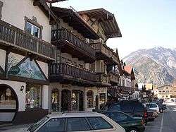
Leavenworth is a city in Chelan County, Washington, United States. It is part of the Wenatchee−East Wenatchee Metropolitan Statistical Area. The population was 1,965 at the 2010 census.[5] The entire town center is modeled on a Bavarian village.
The railroad construction was completed during the winter of 1893. Lafayette Lamb and his brother, Chauncery Lamb, arrived in 1903 from Iowa to build the second largest sawmill in Washington state.
Leavenworth was officially incorporated on September 5, 1906. A small timber community, it became the headquarters of the Great North Railroad in the early 1900s. The railroad relocated to Wenatchee in the 1920s, greatly affecting Leavenworth's economy.
In 1962, the Project LIFE (Leavenworth Improvement For Everyone) Committee was formed in partnership with the University of Washington to investigate strategies to revitalize the struggling logging town. The theme town idea was created by two Seattle business men, Ted Price and Bob Rodgers, who had bought a failing cafe on Highway 2 in 1960. Price was chair of the Project LIFE tourism subcommittee, and in 1965 the pair led a trip to a Danish-themed town Solvang, California to build support for the idea. The first building to be remodeled in the Bavarian style was the Chikamin Hotel, which owner LaVerne Peterson renamed the Edelweiss after the state flower of Bavaria.[6]
Leavenworth is home to the Leavenworth Nutcracker Museum, which opened in 1995 and contains more than 5,000 nutcrackers dating from prehistoric to modern.[7] Leavenworth hosts an annual Oktoberfest celebration.[8] Leavenworth's transformation into a theme town was inspired, and assisted, by Solvang, California. Later, the Washington town of Winthrop followed Leavenworth's example and adopted a town theme.[9]
In November 2007, Good Morning America went to Leavenworth for Holiday Gifts for the Globe where GMA helped light up the town for the Christmas Holiday. Leavenworth was also named the Ultimate Holiday Town USA by A&E.[10]
Geography
Leavenworth's geographic coordinates are 47°35′47″N 120°39′55″W / 47.59639°N 120.66528°W.[11]
According to the United States Census Bureau, the city has a total area of 1.25 square miles (3.24 km2), of which, 1.23 square miles (3.19 km2) is land and 0.02 square miles (0.05 km2) is water.[1]
Geology
Leavenworth sits on the southeast side of the North Cascades collage, which is a group of terranes that accreted to North America all about the same time. Marine fossils indicate that the terranes were probably a group of islands originating out in the South Pacific hundreds of million years ago. The terranes landed on North America about 90mya(million years ago) in the middle of the Cretaceous period. As they smashed into their new home they were a puzzle of north- south slices. As accretion continued they were cut into horizontal (east-west) slices.
During the Eocene epoch, about 50 mya the area was once again cut into vertical slices, creating among others, the Leavenworth fault and the Entiat fault. In between these two faults the Chiwaukum graben was created. ( A graben is a large block of rock that drops between two normal faults). This graben is about 12 miles wide and trends northwest from Wenatchee for about 50 miles. As the graben dropped, it immediately began to fill with clastic sediment from the surrounding hills,creating the Chumstick formation. About 30 mya in the Oligocene epoch the Chiwaukum graben underwent compressional deformation creating several folds in the region, which are visible today. Leavenworth is on the western edge of the graben, in fact the Leavenworth fault runs through the western edge of town. The middle Cretaceous was when the area to the west and southwest of Leavenworth was created, this was the uplift of the Mt.Stuart batholith, forming the granite rock which we see today in Icicle Ridge and Tumwater Mountain.
During the Pleistocene and on into the Holocene epoch Leavenworth would have been a cold place to live. An alpine glacier originating from the southwest in the Mt. Stuart range made its way to where the town is today. Leavenworth actually sits on the terminal moraine of that glacier. A drive through the residential parts of town display many glacier erratic's that originated 20 miles away up the Icicle valley near Mt.Stuart.
About 19,000 years ago a large rock slide dammed the Columbia River near Rock Island (just south of Wenatchee). The temporary dam, in conjunction with one of the Lake Missoula floods, caused the water to flow back up the Wenatchee valley where it was stopped by the glacier at Leavenworth. As the leading edge of the glacier interacted with the flood, ice rafts formed carrying granite erratics from the Stuart batholith ending up in the town of Dryden about 15 miles down valley from Leavenworth. As the glacier retreated, the south side of Leavenworth was a lake dammed up by the moraine. The bridge on the east side of town is a good vantage point to see where the Wenatchee River cuts through the moraine today.
Climate
Leavenworth has a continental Mediterranean climate (Köppen Dsb) with summers characterised by hot, sunny days and chilly nights, and cold, snowy winters.
During the summer, the weather is typically anticyclonic due to the presence of the North Pacific anticyclone, with resultant clear skies and large diurnal temperature ranges. Rainfall is limited by the Cascade rain shadow as well as by the anticyclone, and all months from May to October have recorded zero precipitation on occasions: indeed from June 15 to October 6 of 2003 there were 114 consecutive days with not even a trace of precipitation. When a continental flow enters the Columbia Basin, temperature can be very hot during the day, with the hottest temperature being 110 °F or 43.3 °C during the heatwave of July 1941. However, on cooler, stiller days, summer nights can still be cold and frosts have been recorded as early as August 29 of 1980.
The fall months see steady cooling and a gradual increase in the frequency of frontal storms producing rainfall, whilst winter weather is typically cold and snowy, with an annual mean snowfall of 90.1 inches or 2.29 metres and a maximum monthly total of 92.3 inches (2.34 m) during December 1996. The snowiest season has been from July 1968 to June 1969 with 217.2 inches (5.52 m) and the least snowy from July 1962 to June 1963 when just 19.4 inches (0.49 m) of snow fell. On occasions, as in January and February 1929, and Januaries 1930, 1937, 1949, 1950, 1957 and 1969, very cold and dry Arctic air from western Canada can invade the basin, turning the weather much colder and frequently clearer: the lowest temperature recorded in Leavensworth has been −36 °F (−37.8 °C) on December 30, 1968, though only 5.5 mornings will fall to or below 0 °F or −17.8 °C and numerous mild winters never see such cold temperatures.
The wettest “rain year” has been from July 1955 to June 1956 with a total of 41.13 inches (1,044.7 mm) and the driest from July 1929 to June 1930 with 11.77 inches (299.0 mm). The spring months see gradual warming and drying, though frosts remain frequent into April – over 168 mornings during an average year fall to or below freezing and the average last freeze is on May 16, with 2016 became the first year to record a last frost in March.
| Climate data for Leavenworth, Washington (1971-2000; extremes since 1914) | |||||||||||||
|---|---|---|---|---|---|---|---|---|---|---|---|---|---|
| Month | Jan | Feb | Mar | Apr | May | Jun | Jul | Aug | Sep | Oct | Nov | Dec | Year |
| Record high °F (°C) | 64 (18) |
65 (18) |
79 (26) |
92 (33) |
101 (38) |
105 (41) |
110 (43) |
108 (42) |
104 (40) |
91 (33) |
74 (23) |
60 (16) |
110 (43) |
| Average high °F (°C) | 33.9 (1.1) |
42.0 (5.6) |
52.4 (11.3) |
62.4 (16.9) |
71.4 (21.9) |
78.7 (25.9) |
87.1 (30.6) |
87.6 (30.9) |
78.5 (25.8) |
64.2 (17.9) |
44.0 (6.7) |
33.7 (0.9) |
61.3 (16.3) |
| Average low °F (°C) | 17.2 (−8.2) |
21.6 (−5.8) |
27.3 (−2.6) |
33.4 (0.8) |
40.1 (4.5) |
46.3 (7.9) |
50.6 (10.3) |
50.2 (10.1) |
41.7 (5.4) |
32.8 (0.4) |
27.4 (−2.6) |
19.5 (−6.9) |
34.0 (1.1) |
| Record low °F (°C) | −27 (−33) |
−25 (−32) |
−6 (−21) |
19 (−7) |
24 (−4) |
31 (−1) |
34 (1) |
30 (−1) |
19 (−7) |
11 (−12) |
−10 (−23) |
−36 (−38) |
−36 (−38) |
| Average precipitation inches (mm) | 4.40 (111.8) |
3.23 (82) |
2.09 (53.1) |
1.10 (27.9) |
0.85 (21.6) |
0.84 (21.3) |
0.39 (9.9) |
0.58 (14.7) |
0.75 (19) |
1.74 (44.2) |
4.27 (108.5) |
4.83 (122.7) |
25.07 (636.7) |
| Average snowfall inches (cm) | 27.9 (70.9) |
15.3 (38.9) |
5.1 (13) |
0.3 (0.8) |
0.0 (0) |
0.0 (0) |
0.0 (0) |
0.0 (0) |
0.0 (0) |
0.4 (1) |
9.8 (24.9) |
31.3 (79.5) |
90.1 (229) |
| Average precipitation days (≥ 0.01 inch) | 15.4 | 12.8 | 11.2 | 7.1 | 6.6 | 6.1 | 3.5 | 3.7 | 4.6 | 8.8 | 15.2 | 15.5 | 110.5 |
| Average snowy days (≥ 0.1 inch) | 9.2 | 5.1 | 2.0 | 0.1 | 0.0 | 0.0 | 0.0 | 0.0 | 0.0 | 0.2 | 3.8 | 9.1 | 29.5 |
| Source #1: National Oceanic and Atmospheric Administration[12] | |||||||||||||
| Source #2: National Weather Service (extremes)[13] | |||||||||||||
Demographics
| Historical population | |||
|---|---|---|---|
| Census | Pop. | %± | |
| 1910 | 1,551 | — | |
| 1920 | 1,791 | 15.5% | |
| 1930 | 1,415 | −21.0% | |
| 1940 | 1,608 | 13.6% | |
| 1950 | 1,503 | −6.5% | |
| 1960 | 1,480 | −1.5% | |
| 1970 | 1,322 | −10.7% | |
| 1980 | 1,522 | 15.1% | |
| 1990 | 1,692 | 11.2% | |
| 2000 | 2,074 | 22.6% | |
| 2010 | 1,965 | −5.3% | |
| Est. 2015 | 2,002 | [14] | 1.9% |
| U.S. Decennial Census[15] 2015 Estimate[3] | |||
As of the census[2] of 2010, there were 1,965 people, 908 households, and 500 families residing in the city. The population density was about 1,598 inhabitants per square mile (617.0/km2). There were 1,241 housing units at an average density of about 1,009 per square mile (389.6/km2). The racial makeup of the city was 92.9% White, 0.4% African American, 0.5% Native American, 0.6% Asian, 0.2% Pacific Islander, 3.9% from other races, and 1.6% from two or more races. Hispanic or Latino of any race were 10.8% of the population.
There were 908 households of which about 24% had children under the age of 18 living with them, about 42% were married couples living together, about 10% had a female householder with no husband present, 3% had a male householder with no wife present, and about 45% were non-families. About 37% of all households were made up of individuals and about 20% had someone living alone who was 65 years of age or older. The average household size was 2.16 and the average family size was 2.84.
The median age in the city was about 42 years. About 20% of residents were under the age of 18; about 8% were between the ages of 18 and 24; 25% were from 25 to 44; about 27% were from 45 to 64; and about 20% were 65 years of age or older. The gender makeup of the city was 46.7% male and 53.3% female.
Transportation

- Leavenworth has Amtrak rail service at Leavenworth "Icicle" Station which recently re-opened with a new station in September 2009.
- Leavenworth also has a stop for Northwestern Trailways bus at U.S. Route 2 and Icicle road.[16] This bus can be cross-ticketed with Amtrak Thruway.[17] This Amtrak Thruway Motorcoach service operates as redundant service along the Empire Builder route between Seattle and Spokane to add extra capacity and provide service during other times of the day. The route also serves Stevens Pass, Skykomish, and Monroe. The thruway motorcoach service is used when normal rail service encounters disruptions. E.g. a closure of Cascade Tunnel.
- The Leavenworth Free Trolley that circulates between U.S. Route 2 and Icicle road and the Safeway ended in September 2011.[18]
- Link Transit has a Dial-a-Ride service. The service requires at least a one-day advance notice.[19]
- Leavenworth Taxi also has a shuttle that operates within the greater Leavenworth area.[20] It stops at both the Northwestern Trailways/Amtrak Thruway Motorcoach bus stop and the Amtrak rail station.
See also
Notes
- 1 2 "US Gazetteer files 2010". United States Census Bureau. Retrieved 2012-12-19.
- 1 2 "American FactFinder". United States Census Bureau. Retrieved 2012-12-19.
- 1 2 "Population Estimates". United States Census Bureau. Retrieved July 10, 2016.
- ↑ "US Board on Geographic Names". United States Geological Survey. 2007-10-25. Retrieved 2008-01-31.
- ↑ "2010 Census Redistricting Data (Public Law 94-171) Summary File". American FactFinder. United States Census Bureau. Retrieved 25 September 2012.
- ↑ HistoryLink Leavenworth -- Thumbnail History
- ↑ About Us
- ↑ LeavenworthOktoberfest.com
- ↑ Kirk, Ruth; Carmela Alexander (1990). Exploring Washington's Past: A Road Guide to History. University of Washington Press. pp. 80, 105. ISBN 0-295-97443-5. Retrieved 2009-09-13.
- ↑ ABC News: Holiday Gifts for the Globe
- ↑ "US Gazetteer files: 2010, 2000, and 1990". United States Census Bureau. 2011-02-12. Retrieved 2011-04-23.
- ↑ "Climatography of the United States No. 20: 1971-2000 – Leavenworth 3 S, WA" (PDF). National Oceanic and Atmospheric Administration. Retrieved 2016-11-13.
- ↑ "National Weather Service, Spokane, WA". National Weather Service. Retrieved 2016-11-13.
- ↑ "Annual Estimates of the Resident Population for Incorporated Places: April 1, 2010 to July 1, 2015". Retrieved July 2, 2016.
- ↑ United States Census Bureau. "Census of Population and Housing". Retrieved August 29, 2013.
- ↑ "Icicle Kwik Stop". Northwestern Trailways. Retrieved 2009-10-15.
- ↑ "Leavenworth - LEA". Retrieved 2009-10-16.
- ↑ "Trolley Service in Leavenworth Washington". Retrieved 2009-10-13.
- ↑ "Leavenworth DART". Retrieved 2009-10-10.
- ↑ "Leavenworth Shuttle & Taxi". Retrieved 2009-10-10.
Geology references
- http://wrgis.wr.usgs.gov/wgmt/pacnw/nc/chelan2.html
- http://192.211.16.13/curricular/MN/swauk_formation.htm
- http://academic.evergreen.edu/curricular/geologyandart/Central%20WA%20Field%20Trip%20Guide.pdf (PDF)
- http://192.211.16.13/curricular/MN/chiwaukum_schist.htm
- A geological trip along Snoqualmie, Swauk, and Stevens Pass Highways. Washington state geology department, 1963
- Northwest Exposures. David Alt and Donald W. Hyndman
- Roadside Geology of Washington. David Alt and Donald W. Hyndman
External links
| Wikimedia Commons has media related to Leavenworth, Washington. |
-
 Leavenworth, Washington travel guide from Wikivoyage
 - City of Leavenworth website
- Leavenworth Chamber of Commerce
- Leavenworth, Washington at DMOZ
Municipalities and communities of Chelan County, Washington, United States | ||
|---|---|---|
| Cities |  | |
| CDPs | ||
| Other unincorporated communities | ||
| Indian reservation | ||
| Ghost towns | ||
| Footnotes | ‡This populated place also has portions in an adjacent county or counties | |