Mansfield, South Dakota
| Mansfield, South Dakota | |
|---|---|
| Census-designated place | |
 Mansfield  Mansfield Location within the state of South Dakota | |
| Coordinates: 45°14′35″N 98°33′45″W / 45.24306°N 98.56250°WCoordinates: 45°14′35″N 98°33′45″W / 45.24306°N 98.56250°W | |
| Country | United States |
| State | South Dakota |
| Counties | Brown, Spink |
| Area | |
| • Total | 2.4 sq mi (6.2 km2) |
| • Land | 2.4 sq mi (6.2 km2) |
| • Water | 0.0 sq mi (0.0 km2) |
| Elevation | 1,296 ft (395 m) |
| Population (2010) | |
| • Total | 93 |
| • Density | 39/sq mi (14.9/km2) |
| Time zone | Central (CST) (UTC-6) |
| • Summer (DST) | CDT (UTC-5) |
| ZIP code | 57460 |
| FIPS code | 46-40580 |
| GNIS feature ID | 1256319 |
Mansfield is an unincorporated community and census-designated place on the border between Brown and Spink counties, South Dakota, United States. The population was 93 according to the 2010 census.[1]
Located 2 miles (3 km) west of Highway 281, it is approximately 18 miles (29 km) south of Aberdeen, the third largest city in South Dakota. The James River flows 7 miles (11 km) east of Mansfield, and the surrounding James River Valley is some of the richest farmland in the state. Additionally, this area is widely known for its large variety of game and is a popular pheasant hunting venue.
History
Mansfield was named for John Mansfield, who owned the land where the community is located.[2] John Mansfield was also credited with bringing the railroad to the site.[3]
References
- ↑ "Geographic Identifiers: 2010 Demographic Profile Data (G001): Mansfield CDP, South Dakota". U.S. Census Bureau, American Factfinder. Retrieved April 7, 2014.
- ↑ Chicago and North Western Railway Company (1908). A History of the Origin of the Place Names Connected with the Chicago & North Western and Chicago, St. Paul, Minneapolis & Omaha Railways. p. 97.
- ↑ Federal Writers' Project (1940). South Dakota place-names, v.1-3. University of South Dakota. p. 49.
Municipalities and communities of Brown County, South Dakota, United States | ||
|---|---|---|
| Cities | 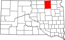 | |
| Towns | ||
| CDPs | ||
| Other unincorporated communities | ||
| Townships |
| |
| Footnotes | ‡This populated place also has portions in an adjacent county or counties | |