Bath, South Dakota
| Bath, South Dakota | |
|---|---|
| Census-designated place | |
 Bath  Bath | |
| Coordinates: 45°28′6″N 98°19′22″W / 45.46833°N 98.32278°WCoordinates: 45°28′6″N 98°19′22″W / 45.46833°N 98.32278°W | |
| Country | United States |
| State | South Dakota |
| County | Brown |
| Area | |
| • Total | 0.29 sq mi (0.75 km2) |
| • Land | 0.29 sq mi (0.75 km2) |
| • Water | 0.0 sq mi (0.0 km2) |
| Elevation | 1,302 ft (397 m) |
| Population (2010) | |
| • Total | 172 |
| • Density | 591/sq mi (228.2/km2) |
| Time zone | Central (CST) (UTC-6) |
| • Summer (DST) | CDT (UTC-5) |
| ZIP code | 57427 |
| Area code(s) | 605 |
Bath is an unincorporated community and census-designated place in Brown County, South Dakota, United States. As of the 2010 census, Bath had a population of 172.[1] Bath has been assigned the ZIP code of 57427.
History
A post office called Bath was established in 1881.[2] The community's name is derived from Bath, England.[3]
References
- ↑ "Geographic Identifiers: 2010 Demographic Profile Data (G001): Bath CDP, South Dakota". U.S. Census Bureau, American Factfinder. Retrieved April 7, 2014.
- ↑ "Brown County". Jim Forte Postal History. Retrieved 22 January 2015.
- ↑ Federal Writers' Project (1940). South Dakota place-names, v.1-3. University of South Dakota. p. 26.
Municipalities and communities of Brown County, South Dakota, United States | ||
|---|---|---|
| Cities | 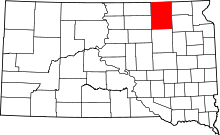 | |
| Towns | ||
| CDPs | ||
| Other unincorporated communities | ||
| Townships |
| |
| Footnotes | ‡This populated place also has portions in an adjacent county or counties | |
This article is issued from Wikipedia - version of the 7/31/2016. The text is available under the Creative Commons Attribution/Share Alike but additional terms may apply for the media files.