Mancos Shale
| Mancos Shale Formation Stratigraphic range: Late Cretaceous | |
|---|---|
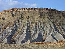 Mancos Shale badlands in Capitol Reef National Park, southern Utah. | |
| Type | Geologic formation |
| Underlies | Mesaverde Formation |
| Overlies | Dakota Group |
| Location | |
| Region | Arizona, Colorado, New Mexico, Utah, Wyoming |
| Country | United States |
| Type section | |
| Named for | Mancos, Colorado |
The Mancos Shale or Mancos Group is an Late Cretaceous (Upper Cretaceous) geologic formation of the Western United States.
The Mancos Shale was first described by Cross and Purington in 1899[1] and was named for exposures near the town of Mancos, Colorado.
Geology
It is dominated by mudrock that accumulated in offshore and marine environments of the Cretaceous North American Inland Sea. The Mancos was deposited during the Cenomanian through Campanian ages, approximately from 95 Ma to 80 Ma.
Stratigraphically the Mancos Shale fills the interval between the Dakota Group and the Mesaverde Formation Group.[2]
The Mancos Shale rests conformably on the Dakota and in its upper part grades into and intertongues with the Mesaverde Group. The shale tongues typically have sharp basal contacts and gradational upper contacts.
Occurrences
The Mancos occurs in the Basin and Range Province, the Colorado Plateau Province, and the San Juan Mountains Province.
Structural basins
It also occurs in the following structural basin:[3]
|
|
Subunits
The Mancos occurs with the following subunit names (listed alphabetically):[3]
|
|
|
See also
- List of fossiliferous stratigraphic units in Arizona
- List of fossiliferous stratigraphic units in Colorado
- List of fossiliferous stratigraphic units in New Mexico
- List of fossiliferous stratigraphic units in Utah
- List of fossiliferous stratigraphic units in Wyoming
References
- ↑ Cross, W. and Purington, C. W. (1899) "Description of the Telluride quadrangle, Colorado" United States Geological Survey Atlas, Folio 57
- ↑ Weimer, R. J. (1960) "Upper Cretaceous Stratigraphy, Rocky Mountain Area" American Association of Petroleum Geologists Bulletin 44: pp. 1-20
- 1 2 "Colorado River Basin Stratigraphy: Mancos Shale" United States Geological Survey
- ↑ New Mexico Geological Association.edu: "SURFACE and SUBSURFACE STRATIGRAPHY of the BURRO CANYON FORMATION, DAKOTA SANDSTONE, and INTERTONGUED MANCOS SHALE of the CHAMA BASIN, NEW MEXICO"; 2005.
| Cretaceous Period | |
|---|---|
| Lower/Early Cretaceous | Upper/Late Cretaceous |
| Berriasian | Valanginian | Hauterivian Barremian| Aptian | Albian |
Cenomanian | Turonian | Coniacian Santonian |Campanian | Maastrichtian |