Malimono, Surigao del Norte
| Malimono | |
|---|---|
| Municipality | |
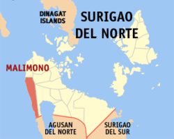 Map of Surigao del Norte with Malimono highlighted | |
.svg.png) Malimono Location within the Philippines | |
| Coordinates: 09°37′N 125°24′E / 9.617°N 125.400°ECoordinates: 09°37′N 125°24′E / 9.617°N 125.400°E | |
| Country | Philippines |
| Region | Caraga (Region XIII) |
| Province | Surigao del Norte |
| Congr. district | 2nd district of Surigao del Norte |
| Barangays | 14 |
| Government[1] | |
| • Mayor | Teodoro Fortich Sinaca Jr. |
| Area[2] | |
| • Total | 80.13 km2 (30.94 sq mi) |
| Population (2010)[3] | |
| • Total | 18,316 |
| • Density | 230/km2 (590/sq mi) |
| Time zone | PST (UTC+8) |
| ZIP code | 8402 |
| Dialing code | 86 |
Malimono is a fifth class municipality in the province of Surigao del Norte, Philippines. According to the 2010 census, it has a population of 18,316 people.[3] The mayor of the municipality is Teodoro Sinaca Jr. while the municipal vice mayor is Rainero Gaviola Caga.[1]
Barangays
Malimono is politically subdivided into 14 barangays.[2]
- Bunyasan
- Cagtinae
- Can-aga
- Cansayong
- Cantapoy
- Cayawan
- Doro (Binocaran)
- Hanagdong
- Karihatag
- Masgad
- Pili
- San Isidro (Poblacion)
- Tinago
- Villariza
Demographics
| Population census of Malimono | ||
|---|---|---|
| Year | Pop. | ±% p.a. |
| 1990 | 16,208 | — |
| 1995 | 14,191 | −2.46% |
| 2000 | 14,597 | +0.61% |
| 2007 | 16,883 | +2.03% |
| 2010 | 18,316 | +3.01% |
| Source: National Statistics Office[3][4] | ||
References
- 1 2 "Official City/Municipal 2013 Election Results". Intramuros, Manila, Philippines: Commission on Elections (COMELEC). 1 July 2013. Retrieved 26 August 2013.
- 1 2 "Province: Surigao del Norte". PSGC Interactive. Makati City, Philippines: National Statistical Coordination Board. Retrieved 26 August 2013.
- 1 2 3 "Total Population by Province, City, Municipality and Barangay: as of May 1, 2010" (PDF). 2010 Census of Population and Housing. National Statistics Office. Retrieved 26 August 2013.
- ↑ "Province of Surigao Del Norte". Municipality Population Data. LWUA Research Division. Retrieved 26 August 2013.
External links
- Philippine Standard Geographic Code
- Philippine Census Information
- Local Governance Performance Management System
 |
San Francisco | Sison | | |
| Bohol Sea | |
Mainit | ||
| ||||
| | ||||
| Jabonga, Agusan del Norte |
Surigao City (capital) | |
| Municipalities | |
| Component city | |
This article is issued from Wikipedia - version of the 7/8/2016. The text is available under the Creative Commons Attribution/Share Alike but additional terms may apply for the media files.