Mafalda, Molise
| Mafalda | |
|---|---|
| Comune | |
| Comune di Mafalda | |
 Mafalda Location of Mafalda in Italy | |
| Coordinates: 41°57′N 14°43′E / 41.950°N 14.717°ECoordinates: 41°57′N 14°43′E / 41.950°N 14.717°E | |
| Country | Italy |
| Region | Molise |
| Province / Metropolitan city | Province of Campobasso (CB) |
| Area | |
| • Total | 32.6 km2 (12.6 sq mi) |
| Elevation | 460 m (1,510 ft) |
| Population (Dec. 2004) | |
| • Total | 1,308 |
| • Density | 40/km2 (100/sq mi) |
| Time zone | CET (UTC+1) |
| • Summer (DST) | CEST (UTC+2) |
| Postal code | 86030 |
| Dialing code | 0875 |
| Website | Official website |
Mafalda is a comune (municipality) in the Province of Campobasso in the Italian region Molise, located about 45 kilometres (28 mi) north of Campobasso. As of 31 December 2004, it had a population of 1,308 and an area of 32.6 square kilometres (12.6 sq mi).[1]
Mafalda borders the following municipalities: Dogliola, Fresagrandinaria, Lentella, Montenero di Bisaccia, San Felice del Molise, Tavenna, Tufillo.
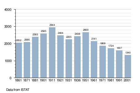
Demographic evolution
References
External links
This article is issued from Wikipedia - version of the 1/31/2015. The text is available under the Creative Commons Attribution/Share Alike but additional terms may apply for the media files.