Ripabottoni
| Ripabottoni | |
|---|---|
| Comune | |
| Comune di Ripabottoni | |
 Ripabottoni Location of Ripabottoni in Italy | |
| Coordinates: 41°41′N 14°49′E / 41.683°N 14.817°ECoordinates: 41°41′N 14°49′E / 41.683°N 14.817°E | |
| Country | Italy |
| Region | Molise |
| Province / Metropolitan city | Province of Campobasso (CB) |
| Area | |
| • Total | 31.9 km2 (12.3 sq mi) |
| Elevation | 695 m (2,280 ft) |
| Population (Dec. 2004) | |
| • Total | 644 |
| • Density | 20/km2 (52/sq mi) |
| Time zone | CET (UTC+1) |
| • Summer (DST) | CEST (UTC+2) |
| Postal code | 86040 |
| Dialing code | 0874 |
Ripabottoni is a comune (municipality) in the Province of Campobasso in the Italian region Molise, located about 20 kilometres (12 mi) northeast of Campobasso. As of 31 December 2004, it had a population of 644 and an area of 31.9 square kilometres (12.3 sq mi).[1]
Ripabottoni borders the following municipalities: Bonefro, Campolieto, Casacalenda, Monacilioni, Morrone del Sannio, Provvidenti, Sant'Elia a Pianisi.
Famous People from Ripabottoni
- Arturo Giovannitti, labor organizer in the United States, born in Ripabottoni
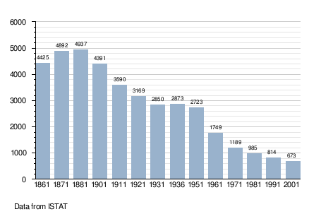
Demographic evolution
References
This article is issued from Wikipedia - version of the 1/31/2015. The text is available under the Creative Commons Attribution/Share Alike but additional terms may apply for the media files.