Macedonia, Alabama
| Macedonia, Alabama | |
|---|---|
| Census-designated place | |
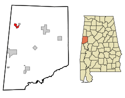 Location in Pickens County and the state of Alabama | |
| Coordinates: 33°24′9″N 88°14′23″W / 33.40250°N 88.23972°W | |
| Country | United States |
| State | Alabama |
| County | Pickens |
| Area | |
| • Total | 3.9 sq mi (10.2 km2) |
| • Land | 3.9 sq mi (10.2 km2) |
| • Water | 0 sq mi (0 km2) |
| Elevation | 338 ft (103 m) |
| Population (2010) | |
| • Total | 292 |
| • Density | 75/sq mi (29/km2) |
| Time zone | Central (CST) (UTC-6) |
| • Summer (DST) | CDT (UTC-5) |
| FIPS code | 01-45316 |
| GNIS feature ID | 1669448 |
Macedonia is a census-designated place and former town in Pickens County, Alabama, United States. The population was 292 at the 2010 census, up from 291 in 2000.[1] The town was incorporated in 1994,[2] but disincorporated in 2001.[3] It was reclassified as a census-designated place (CDP) for 2010.
Geography
According to the United States Census Bureau, the town had a total area of 2.2 square miles (5.7 km2), all land.
Demographics
| Historical population | |||
|---|---|---|---|
| Census | Pop. | %± | |
| 2000 | 291 | — | |
| 2010 | 292 | 0.3% | |
| U.S. Decennial Census[4] | |||
As of the 2010 United States Census, there were 292 people residing in the CDP. 91.1% were African American and 8.9% White.
As of the census[5] of 2000, there were 291 people, 114 households, and 69 families residing in the town. The population density was 131.4 people per square mile (50.8/km²). There were 141 housing units at an average density of 63.7 per square mile (24.6/km²). The racial makeup of the town was 6.53% White, 91.75% Black or African American, 0.69% Native American, and 1.03% from two or more races.
There were 114 households out of which 30.7% had children under the age of 18 living with them, 32.5% were married couples living together, 21.1% had a female householder with no husband present, and 38.6% were non-families. 37.7% of all households were made up of individuals and 16.7% had someone living alone who was 65 years of age or older. The average household size was 2.55 and the average family size was 3.44.
In the town the population was spread out with 29.9% under the age of 18, 9.3% from 18 to 24, 27.5% from 25 to 44, 19.2% from 45 to 64, and 14.1% who were 65 years of age or older. The median age was 33 years. For every 100 females there were 92.7 males. For every 100 females age 18 and over, there were 98.1 males.
The median income for a household in the town was $23,958, and the median income for a family was $29,688. Males had a median income of $26,042 versus $16,875 for females. The per capita income for the town was $9,456. About 30.6% of families and 33.3% of the population were below the poverty line, including 40.2% of those under the age of 18 and 58.8% of those 65 or over.
References
- ↑ "American FactFinder". United States Census Bureau. Retrieved 2011-05-14.
- ↑ http://www.census.gov/popest/data/historical/1990s/boundary_changes/01.html
- ↑ U.S. Census Bureau Geographic Change Notes
- ↑ "U.S. Decennial Census". Census.gov. Retrieved June 6, 2013.
- ↑ "American FactFinder". United States Census Bureau. Retrieved 2008-01-31.
Coordinates: 33°23′29″N 88°14′00″W / 33.391427°N 88.233304°W
Municipalities and communities of Pickens County, Alabama, United States | ||
|---|---|---|
| Cities | 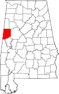 | |
| Towns | ||
| CDP | ||
| Unincorporated communities | ||