M Ocean View
The M Ocean View is a Muni Metro light rail line in San Francisco, California. It was one of San Francisco's streetcar lines in the early 20th century.
History
The M Ocean View line began operation in 1925[2] with the outbound terminus at the intersection of Broad Street and Plymouth Avenue in the city's Ocean View District, where streetcars used a wye to turn around. Service along this route was replaced by buses in 1939, but rail service was shortly restored in 1944.[2] While many streetcar lines were permanently converted to buses after World War II, the M Ocean View remained a streetcar line due to its use of the Twin Peaks Tunnel. On August 30, 1980, the line was extended to Balboa Park BART station.[3] The line was partially converted to modern light-rail operation with the opening of the Muni Metro system in 1980. Eureka Station in the Twin Peaks Tunnel was originally a stop in regular service, but the station was closed in 1972 and replaced, ten years later, by Castro Street Station when the Market Street Subway system opened.
Route description
The line runs from the Embarcadero Station in the Financial District to Geneva Avenue and San Jose Avenue near City College of San Francisco in the Balboa Park neighborhood. The downtown portion of the line runs through the Market Street Subway, which it shares with the four other Muni Metro lines. It continues through the much older Twin Peaks Tunnel, along with the K Ingleside and L Taraval lines, emerging at West Portal Station. From there, it follows West Portal Avenue to the Saint Francis Circle, where it then takes its own right-of-way to 19th Avenue. The portion of the line on 19th Avenue between where it joins 19th near Eucalyptus Drive and Junipero Serra Boulevard is a right-of-way separated from the street. This section has two stations with high-platforms, one at the Stonestown Galleria on Winston Drive and the other at San Francisco State University on Holloway Avenue. It continues on 19th Avenue past Junipero Serra to Randolph Street. At the end of Randolph, the M uses Orizaba Avenue to get to Broad Street and takes that to San Jose Avenue. The rest of the line follows San Jose Avenue to Geneva Avenue, where the line loops around the Metro yard there on the corner opposite from Balboa Park Station.
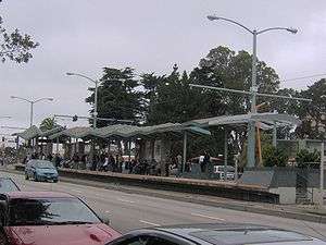
The M Ocean View line stops at large stations for the downtown section of the route and on 19th Avenue and at smaller stops on the rest of the line. Most of the smaller stops are nothing more than a sign on the side of the street designating a stop and a few others are concrete 'islands' in the middle of the street next to the tracks that provide access for wheelchairs. Muni bus routes provide service to all stations and other systems with access to the stations are noted.
19th Avenue Transit Study
M Ocean View moves at only 8.5 to 9.5 miles per hour (13.7 to 15.3 km/h) during afternoon commute hours over a 2-mile (3.2 km) distance along 19th Avenue/Highway 1. The slow speed is attributed to stopping the train at multiple busy street crossings.[4] In addition, the majority of riders access 19th Avenue stops from the west side of 19th, since Stonestown Galleria, San Francisco State University and Parkmerced are all located west of 19th. In order to access the stops, which are located in the median of 19th Avenue, pedestrians cross three lanes of traffic and a turn lane. In San Francisco, 55% of severe and fatal pedestrian accidents occur on 7% of its street miles, which includes the 19th Avenue/Highway 1 corridor.[5] In response, the San Francisco County Transportation Authority commissioned a study, published in 2014 to explore options to facilitate pedestrian access and improve travel times.
The highest-performing option was named the "Longer subway and bridge" for its major features. This alternative proposed taking trains underground just south of St. Francis Circle before crossing Ocean Avenue in the private right-of-way. Instead of crossing Holloway on 19th, the tracks would be realigned in a south-southwest direction to run closer to Juan Bautista Circle in Parkmerced. Southbound tracks would surface on the west side of 19th Avenue south of Buckingham Way, while northbound tracks would remain underground until Font Boulevard south of Gonzalez Drive. From Font, both tracks would travel on a new bridge across Junipero Serra and touch down on Randolph, thereafter maintaining the current alignment. This was estimated to save the average transit rider five minutes and would likely cost US$520,000,000 (equivalent to $521,000,000 in 2015).[4] The Draft Rail Capacity Strategy, released by Muni in 2016, listed the 19th Street Grade Separation as a Tier 1 Long Term Corridor Investment (the highest priority) with estimated costs between $2.5- and $3-billion.[6]
Operation
The M Ocean View begins service at 5 a.m. weekdays, 6 a.m. Saturdays and 8 a.m. Sundays, with the end of service occurring around 12:30 a.m. each night. It operates a headway of 9 to 12 minutes during the day, and 15 to 20 minutes at night. There is no late night service along the entire M line, however part of the L-Owl diesel bus line runs from West Portal Station to Market Street and Steuart Street, near Embarcadero Station, and the 91 Owl line operates on 19th Avenue. On Sunday mornings only, there is a M-Owl diesel bus line that runs on surface streets from Market Street and Steuart Street to Balboa Park between the times owl service stops and the underground subway stations open.
St. Francis Circle Project
In May 2010, the San Francisco MTA began a major project to reconstruct and replace the rail junction at St. Francis Circle. The MTA decided to discontinue all M Ocean View rail service for the duration of the project.[7] Passengers were required to take K Ingleside trains (which temporarily terminated at 14th Avenue) or L Taraval trains and transfer to temporary shuttle bus service at West Portal. Full M Ocean View service was restored on Sept. 4, 2010.[8]
Station and stop listing
inbound to outbound
| Station | Neighborhood | Other Muni Metro lines |
Notes |
|---|---|---|---|
| | Financial District | | Inbound terminus Connects to F Market & Wharves and BART Serves Ferry Building |
| | Financial District | | Connects to F Market & Wharves and BART |
| | Financial District | | Connects to F Market & Wharves and BART |
| | Civic Center | | Connects to F Market & Wharves and BART |
| | Civic Center and Tenderloin | | Connects to F Market & Wharves |
| | Duboce Triangle | | *Connects with J Church on surface stop at 14th Street Connects with F Market & Wharves streetcar |
| | Castro | | |
| | Forest Hill and Laguna Honda | | |
| | West Portal | | |
| West Portal and 14th Avenue | West Portal | | |
| | St. Francis Wood | | |
| Ocean | Merced Manor | right-of-way | |
| Eucalyptus | Merced Manor | right-of-way | |
| | Parkmerced | Intersection of 19th and Winston serves Stonestown Galleria | |
| | Parkmerced | Intersection of 19th and Holloway serves nearby SFSU | |
| 19th Avenue and Junipero Serra | Merced Heights | ||
| Randolph and 19th Avenue | Merced Heights | ||
| | Merced Heights | ||
| Randolph and Bright | Ingleside | ||
| Broad and Orizaba | Ingleside | ||
| Broad and Capitol | Ingleside | ||
| | Ingleside | ||
| San Jose and Farallones | Ingleside | ||
| San Jose and Lakeview | Ingleside | ||
| San Jose and Mount Vernon | Ingleside | ||
| San Jose and Niagra | Ingleside | ||
| | Ingleside | | Outbound terminus Within walking distance of Balboa Park BART station *(served by J Church and K Ingleside directly) |
References
- ↑ "TEP Route Data & Proposed Changes". San Francisco Municipal Transportation Agency (SFMTA). 2013. Retrieved 2013-12-15.
- 1 2 3 Demery, Jr., Leroy W. (November 2011). "U.S. Urban Rail Transit Lines Opened From 1980" (pdf). publictransit.us. Retrieved November 2, 2013.
- ↑ McKane, John; Perles, Anthony (1982). Inside Muni: The Properties and Operations of the Municipal Railway of San Francisco. Glendale, CA (US): Interurban Press. p. 198. ISBN 0-916374-49-1.
- 1 2 19th Avenue Transit Study (PDF) (Report). San Francisco County Transportation Authority. March 2014. Archived (PDF) from the original on 2 April 2015. Retrieved 22 March 2016.
- ↑ WalkFirst: Improving Safety & Walking Conditions in San Francicso (PDF) (Report). San Francisco Department of Public Health. October 2011. Retrieved 22 March 2016.
4.3 HIGH-INJURY DENSITY CORRIDORS
The identified corridors shown in blue in Map 3 represent 6.7% of San Francisco's street miles, and include 55% of all severe and fatal injuries and 51% of total pedestrian injuries in the five-year period. - ↑ "Draft Rail Capacity Study - February 2016" (PDF). SFMTA. Retrieved 20 February 2016.
- ↑ "SFMTA Announces Details of St. Francis Circle Project to Begin in May". San Francisco Municipal Transportation Agency (SFMTA). April 29, 2010. Retrieved 2013-12-01.
- ↑ "SFMTA Prepares to Restore 61 Percent of Muni May 8 Service Cuts and Completes St. Francis Circle Project". San Francisco Municipal Transportation Agency (SFMTA). September 2, 2010. Retrieved 2013-12-01.
External links
- Muni Metro and San Francisco rail map (195KB PDF)
- M Ocean View route information from the SF Muni Map Project
| Muni Metro | |
|---|---|
| Muni Metro System features | |
| Heritage streetcar services | |
| Other Muni services | |
| Projects | |
| Connecting services | |
| Agencies and organizations | |
| Museums | |
| Miscellaneous | |
Category | |