M23 (New York City bus)
| M23 Select Bus Service | |||||||||||||||||||||||||||||||||||||||||||||||||||||||||||||||||||||||||||||||||||||||||||||||||||||||||||||||||||||||||||||||||||||||||||||||||||||||||||||||||||||||||||||||||||||||||
|---|---|---|---|---|---|---|---|---|---|---|---|---|---|---|---|---|---|---|---|---|---|---|---|---|---|---|---|---|---|---|---|---|---|---|---|---|---|---|---|---|---|---|---|---|---|---|---|---|---|---|---|---|---|---|---|---|---|---|---|---|---|---|---|---|---|---|---|---|---|---|---|---|---|---|---|---|---|---|---|---|---|---|---|---|---|---|---|---|---|---|---|---|---|---|---|---|---|---|---|---|---|---|---|---|---|---|---|---|---|---|---|---|---|---|---|---|---|---|---|---|---|---|---|---|---|---|---|---|---|---|---|---|---|---|---|---|---|---|---|---|---|---|---|---|---|---|---|---|---|---|---|---|---|---|---|---|---|---|---|---|---|---|---|---|---|---|---|---|---|---|---|---|---|---|---|---|---|---|---|---|---|---|---|---|---|
| 23rd Street Crosstown Line | |||||||||||||||||||||||||||||||||||||||||||||||||||||||||||||||||||||||||||||||||||||||||||||||||||||||||||||||||||||||||||||||||||||||||||||||||||||||||||||||||||||||||||||||||||||||||
|
| |||||||||||||||||||||||||||||||||||||||||||||||||||||||||||||||||||||||||||||||||||||||||||||||||||||||||||||||||||||||||||||||||||||||||||||||||||||||||||||||||||||||||||||||||||||||||
|
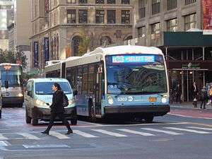
A Chelsea Piers-bound M23 SBS bus at Park Avenue. | |||||||||||||||||||||||||||||||||||||||||||||||||||||||||||||||||||||||||||||||||||||||||||||||||||||||||||||||||||||||||||||||||||||||||||||||||||||||||||||||||||||||||||||||||||||||||
| Overview | |||||||||||||||||||||||||||||||||||||||||||||||||||||||||||||||||||||||||||||||||||||||||||||||||||||||||||||||||||||||||||||||||||||||||||||||||||||||||||||||||||||||||||||||||||||||||
| System | MTA Regional Bus Operations | ||||||||||||||||||||||||||||||||||||||||||||||||||||||||||||||||||||||||||||||||||||||||||||||||||||||||||||||||||||||||||||||||||||||||||||||||||||||||||||||||||||||||||||||||||||||||
| Operator | New York City Transit Authority | ||||||||||||||||||||||||||||||||||||||||||||||||||||||||||||||||||||||||||||||||||||||||||||||||||||||||||||||||||||||||||||||||||||||||||||||||||||||||||||||||||||||||||||||||||||||||
| Garage | Michael J. Quill Depot | ||||||||||||||||||||||||||||||||||||||||||||||||||||||||||||||||||||||||||||||||||||||||||||||||||||||||||||||||||||||||||||||||||||||||||||||||||||||||||||||||||||||||||||||||||||||||
| Vehicle |
| ||||||||||||||||||||||||||||||||||||||||||||||||||||||||||||||||||||||||||||||||||||||||||||||||||||||||||||||||||||||||||||||||||||||||||||||||||||||||||||||||||||||||||||||||||||||||
| Livery | Select Bus Service | ||||||||||||||||||||||||||||||||||||||||||||||||||||||||||||||||||||||||||||||||||||||||||||||||||||||||||||||||||||||||||||||||||||||||||||||||||||||||||||||||||||||||||||||||||||||||
| Route | |||||||||||||||||||||||||||||||||||||||||||||||||||||||||||||||||||||||||||||||||||||||||||||||||||||||||||||||||||||||||||||||||||||||||||||||||||||||||||||||||||||||||||||||||||||||||
| Locale | Manhattan | ||||||||||||||||||||||||||||||||||||||||||||||||||||||||||||||||||||||||||||||||||||||||||||||||||||||||||||||||||||||||||||||||||||||||||||||||||||||||||||||||||||||||||||||||||||||||
| Communities served | Chelsea, Flatiron District, Gramercy Park, Kips Bay, Stuyvesant Town–Peter Cooper Village | ||||||||||||||||||||||||||||||||||||||||||||||||||||||||||||||||||||||||||||||||||||||||||||||||||||||||||||||||||||||||||||||||||||||||||||||||||||||||||||||||||||||||||||||||||||||||
| Start | Chelsea Piers – off West Side Highway near 22nd Street | ||||||||||||||||||||||||||||||||||||||||||||||||||||||||||||||||||||||||||||||||||||||||||||||||||||||||||||||||||||||||||||||||||||||||||||||||||||||||||||||||||||||||||||||||||||||||
| Via | 23rd Street | ||||||||||||||||||||||||||||||||||||||||||||||||||||||||||||||||||||||||||||||||||||||||||||||||||||||||||||||||||||||||||||||||||||||||||||||||||||||||||||||||||||||||||||||||||||||||
| End | Avenue C and 20th Street | ||||||||||||||||||||||||||||||||||||||||||||||||||||||||||||||||||||||||||||||||||||||||||||||||||||||||||||||||||||||||||||||||||||||||||||||||||||||||||||||||||||||||||||||||||||||||
| Service | |||||||||||||||||||||||||||||||||||||||||||||||||||||||||||||||||||||||||||||||||||||||||||||||||||||||||||||||||||||||||||||||||||||||||||||||||||||||||||||||||||||||||||||||||||||||||
| Operates | 24 hours[1] | ||||||||||||||||||||||||||||||||||||||||||||||||||||||||||||||||||||||||||||||||||||||||||||||||||||||||||||||||||||||||||||||||||||||||||||||||||||||||||||||||||||||||||||||||||||||||
| Daily ridership | 3,831,755 (2015)[2] | ||||||||||||||||||||||||||||||||||||||||||||||||||||||||||||||||||||||||||||||||||||||||||||||||||||||||||||||||||||||||||||||||||||||||||||||||||||||||||||||||||||||||||||||||||||||||
| Fare | $2.75 (MetroCard or coins) | ||||||||||||||||||||||||||||||||||||||||||||||||||||||||||||||||||||||||||||||||||||||||||||||||||||||||||||||||||||||||||||||||||||||||||||||||||||||||||||||||||||||||||||||||||||||||
| Cash | Coins only (exact change required) | ||||||||||||||||||||||||||||||||||||||||||||||||||||||||||||||||||||||||||||||||||||||||||||||||||||||||||||||||||||||||||||||||||||||||||||||||||||||||||||||||||||||||||||||||||||||||
| Transfers | Yes | ||||||||||||||||||||||||||||||||||||||||||||||||||||||||||||||||||||||||||||||||||||||||||||||||||||||||||||||||||||||||||||||||||||||||||||||||||||||||||||||||||||||||||||||||||||||||
| Timetable | M23 | ||||||||||||||||||||||||||||||||||||||||||||||||||||||||||||||||||||||||||||||||||||||||||||||||||||||||||||||||||||||||||||||||||||||||||||||||||||||||||||||||||||||||||||||||||||||||
| |||||||||||||||||||||||||||||||||||||||||||||||||||||||||||||||||||||||||||||||||||||||||||||||||||||||||||||||||||||||||||||||||||||||||||||||||||||||||||||||||||||||||||||||||||||||||
The 23rd Street Crosstown Line is a surface transit line on 23rd Street in Manhattan, New York City, United States. It currently hosts the M23 bus route of MTA's Regional Bus Operations. The M23 runs between Chelsea Piers, along the West Side Highway near 22nd Street, via 23rd Street, to Avenue C and 20th Street in Stuyvesant Town–Peter Cooper Village.
It replaces a street railway called the Twenty-third Street Railway. On November 6, 2016, it became a Select Bus Service (SBS) route.
Route
For most of its length, the M23 uses 23rd Street to travel crosstown. There is a one-block stretch of the route, between 11th and 12th Avenues, that runs along 24th Street; this is because the M23 needs to access a bus loop at Chelsea Piers, which is along the West Side Highway near 22nd Street, but it must use 24th Street since 23rd Street ends at 11th Avenue.[1][3] The westbound route between Avenue C and 1st Avenue runs along 20th Street because it needs to terminate along Avenue C in Stuyvesant Town–Peter Cooper Village.[1][3]
Connections
The M23 intersects with every New York City Bus line that it encounters along its crosstown route, as well as some New York City Subway stations.[1][3] Along Avenue C and 20th Street in Peter Cooper Village, in both directions, the M23 shares bus stops with the M9 route.[1][3] At the intersections of both 20th and 23rd Streets with 1st Avenue, the northbound M15 and M15 Select Bus Service (SBS) has stops on 1st Avenue, close to the M23 stops. The corresponding southbound M15/M15 SBS stops are at 2nd Avenue.[1][3] The southbound M9 and eastbound M34A SBS share an eastbound run with the M23 between 2nd Avenue and FDR Drive.[1][3] At 3rd Avenue, the M101, M102, and M103 are all nearby.[1][3] The northbound M1, M2, and M3 stop on Park Avenue. The 23rd Street station of the IRT Lexington Avenue Line, under Park Avenue, serves the 6 <6> services.[1][3] At 5th Avenue and Broadway, near Madison Square, there is a transfer to the southbound M1, M2, and M3; the southbound M5, and the 23rd Street station of the BMT Broadway Line (serving the N R W routes).[1][3]
At 6th Avenue, the M23 encounters the northbound M5 and M7; the 23rd Street station of the IND Sixth Avenue Line, along the F M services; and the 23rd Street station of the PATH, next to the Sixth Avenue Line station.[1][3] The intersection with 7th Avenue provides a transfer to the downtown M7 and M20, and the 23rd Street station of the IRT Broadway–Seventh Avenue Line, served by the 1 train.[1][3] At 8th Avenue, the northbound M20 is nearby, as is the 23rd Street station of the IND Eighth Avenue Line's C E routes.[1][3] Transfers to the southbound and northbound M11 are made at 9th and 10th Avenues, respectively.[1][3] Finally, at 11th Avenue just east of the M23's terminus, there is a transfer to both directions of the M12 bus.[1][3]
A total of 14 local or Select Bus Service (SBS) routes intersect the M23, as well as the PATH and five subway stations. In addition, 28 express bus routes run along 23rd Street, and thus, a non-free transfer either to or from the M23.[4]:5
Stops
| Station Street traveled |
Direction | Connections | |
|---|---|---|---|
| 12th Avenue Chelsea Piers |
Westbound terminus, Eastbound station | ||
| 12th Avenue West 24th Street |
Bidirectional | ||
| 11th Avenue West 23rd Street |
Bidirectional | ||
| 10th Avenue West 23rd Street |
Bidirectional | ||
| 9th Avenue West 23rd Street |
Bidirectional | ||
| 8th Avenue West 23rd Street |
Bidirectional |
NYC Bus: M20 (northbound only) | |
| 7th Avenue West 23rd Street |
Bidirectional |
NYC Bus: M7, M20 (southbound only) | |
| 6th Avenue West 23rd Street |
Bidirectional |
NYC Bus: M5, M7 (northbound only) | |
| Broadway East 23rd Street |
Bidirectional |
NYC Bus: M1, M2, M3, M5 (all buses southbound only) | |
| Park Avenue South East 23rd Street |
Bidirectional |
NYC Bus: M1, M2, M3 (northbound only) | |
| Third Avenue East 23rd Street |
Bidirectional | ||
| Second Avenue East 23rd Street |
Bidirectional | ||
| First Avenue East 23rd Street |
Bidirectional | ||
| Westbound only | |||
| First Avenue East 20th Street |
Westbound | ||
| East 20th Street Loop East 20th Street |
Westbound | ||
| Eastbound only | |||
| East 23rd Street Avenue C |
Eastbound | ||
| East 20th Street Avenue C |
Eastbound terminus, westbound station | ||
History
Streetcars

The Twenty-third Street Railway was a street railway that was originally operated as horse cars and later electric traction. The company was chartered on January 29, 1872.[5][6] Its trackage ran along 23rd Street between 13th Avenue at the Hudson River and the East River east of Avenue A, with a depot on the north side of 23rd Street between 13th and 11th Avenues.[7]:287 Most of this trackage was built by the Twenty-third Street Railway, with three exceptions: a double-track segment between Broadway and Fourth Avenue, built as per an 1860 grant by the Forty-second Street and Grand Street Ferry Railroad; another double-track portion between First Avenue and the former Asser Levy Place, built under another 1860 grant by the Central Park, North and East River Railroad Company; and a single-track portion between Second and First Avenues, built as per a grant awarded to the Second Avenue Railroad in 1852 and confirmed in 1854. In the last instance, the Twenty-third Street Railway removed the Second Avenue Railroad track in the middle of the street, and added double tracks on the curbside of the street, of which the eastbound track was to be shared with the Second Avenue Railroad.[7]:287
The railway leased the Bleecker Street and Fulton Ferry Railroad, which ran from 14th Street on the Hudson River to Fulton Ferry on the East River, on January 10, 1876, for a duration of 99 years.[8]:187[9]:878 Both of these railroads were leased by larger companies.[9]:878 The lease lasted until April 25, 1893,[9]:878 at which time the Twenty-third Street Railway was leased to the Houston, West Street and Pavonia Ferry Railroad.[5][8]:187[9]:878 The Houston, West Street and Pavonia Ferry Railroad was consolidated into the Metropolitan Street Railway on December 12, 1893.[8]:185
The Metropolitan Street Railway was leased by the Interurban Street Railway on April 1, 1902,[10][11] which changed its name to the New York City Railway on February 10, 1904.[10][11] That company went bankrupt in 1908,[11] and the Metropolitan Street Railway separated on July 31.[12]:325 Upon consolidation, it became the 23rd Street Crosstown Line.[8]:187
Bus service
Trolley service along the line ended on April 8, 1936.[13][14][15]:1 A New York City Omnibus Corporation bus route (M18-15)[16][17] replaced the 23rd Street Crosstown Line trolley.[18]:238 The bus was taken over by the Manhattan and Bronx Surface Transit Operating Authority (MaBSTOA) in 1962.[16] The route became the M26 on July 1, 1974 as part of the renumbering of bus routes in Manhattan.[19][20][21] The bus route had been numbered 15, and before its renumbering there were three Manhattan routes numbered 15. The 15 Jackson Heights–Fifth Avenue was renumbered to M32 at the same time, while the M15 Second and First Avenue line retained its number.[19]
The bus was renamed the M23 to match the street it ran on in 1989.[22][23]
In 2010, it was one of seven local bus routes in Manhattan to participate in a PayPass smart card program. This program was a pilot program meant to find a suitable smart card technology to replace the MetroCard.[24][25]
Select Bus Service
The M23 route has been traditionally crowded, with 4,862,343 riders in 2010 and 3,831,755 riders in 2015, or 15,000 riders a day.[4]:5[2] It is also among the city's slowest bus routes, running at an average of 4.7 miles per hour (7.6 km/h) in 2000,[26]:D.2–5 and 3.7 miles per hour (6.0 km/h) by 2015.[27] In 2003, the Straphangers Campaign gave the M23 the "Pokey Award" because it ran slower than any other bus route in all of New York City, at an average speed of 4 miles per hour (6.4 km/h);[28][29] it also got that distinction in 2007 when it also ran at an average of 4 miles per hour (6.4 km/h), slightly faster than the average walking speed of 3 miles per hour (4.8 km/h).[28][30] Rush hour bus headways on the M23 are supposed to be 4.5 to 5.5 minutes.[26]:D.2–3 A 2015 report found that half of the average M23 bus's time is spent either at a bus stop or stopped in traffic; that 28% of the duration of the average M23 trip is spent waiting at bus stops due to passengers boarding; and that the M23 only moves at over 15 miles per hour (24 km/h) for an average of 10% of each trip.[4]:6 This was exacerbated by 23rd Street's varying width of 52 to 66 feet (16 to 20 m), causing buses to need to change lanes frequently; as well as the fact that bus stops were frequently blocked by other traffic.[4]:7 23rd Street was also designated as a "Vision Zero Corridor" due to the high rate of injuries along the street (714 traffic-related injuries, 75 of them serious, as well as 5 deaths due to traffic incidents between 2009 and 2013).[4]:8 Double parking was one of the issues that frequently caused M23 buses to run so slowly.[4]:9
In 2009, the MTA and the New York City Department of Transportation (NYCDOT) identified the M14A/D, on parallel 14th Street, as a potential corridor for Phase II of SBS, the city's bus rapid transit system, as well as finalized plans to implement SBS on the M16/M34 along the also-parallel 34th Street. The crosstown bus corridors were noted for slow travel speeds.[31] The M23 was originally not planned to be an SBS route, but in 2008, it had been part of a pilot program in which 30 articulated, redesigned SBS buses were rolled out on the M23 for some time.[32]
After lengthy consultation, the M23 was converted to SBS on November 6, 2016,[33][34] with all-door boarding, off-board fare payment, dedicated New York City Bus lanes, and BusTime-equipped countdown clocks at some stops.[35][36]:10 This is keeping in line with other SBS routes with the same upgrades, which have seen their average speeds increase between 10% and 25% after implementation.[36]:10 It will replace M23 local service at the cost of $1.7 million.[35] The M23 SBS will keep the same route as the M23 local, with one redundant westbound stop on 5th Avenue and a bidirectional stop on Lexington Avenue being eliminated.[36]:9[37][38] Another bus stop, at the intersection of 20th Street and the western portion of the 20th Street Loop, was planned for elimination,[38] but was retained after community members objected; their objections included that removing the bus stop would make it harder for the elderly residents of Peter Cooper Village to travel to the nearest M23 stop, and that the gap between stops would be 1,848 feet (563 m), or about 0.35 miles, if the stop were eliminated.[39] The implementation plan included repainting 23rd Street so that it would have 5 lanes throughout most of its length; between 2nd and 8th Avenues, two of these lanes—one in each direction—would be bus lanes, with westbound bus lanes between 1st and 2nd Avenues, and eastbound bus lanes between 10th and 8th Avenues.[36]:5 The SBS plan excluded a proposal for bus lanes in the median of 23rd Street,[40] which were proposed by three different community boards due to parking issues on 34th Street after SBS was implemented there.[41]
References
- 1 2 3 4 5 6 7 8 9 10 11 12 13 14 15 M23 bus schedule MTA Regional Bus Operations.
- 1 2 "Facts and Figures". mta.info. August 28, 2011. Retrieved January 19, 2016.
- 1 2 3 4 5 6 7 8 9 10 11 12 13 14 "Manhattan Bus Map" (PDF). Metropolitan Transportation Authority. 2016. Retrieved September 22, 2016.
- 1 2 3 4 5 6 "M23 Select Bus Service" (PDF). nyc.gov. New York City Department of Transportation; Metropolitan Transportation Authority. October 13, 2015. Retrieved September 22, 2016.
- 1 2 "NEW YORK CITY TRANSIT". CHICAGO TRANSIT & RAILFAN. Retrieved September 22, 2016.
- ↑ "Full text of "Street railways of greater New York"". Internet Archive. May 1, 1937. Retrieved September 23, 2016.
- 1 2 Reports of Decisions of the Public Service Commission, First District of the State of New York. 4. New York State Public Service Commission, First District. 1914. Retrieved September 22, 2016 – via Google Books.
- 1 2 3 4 Reports of Decisions. 3. 1913. Retrieved September 22, 2016 – via Google Books.
- 1 2 3 4 Annual Report of the Board of Railroad Commissioners of the State of New York. 2. 1895. Retrieved September 22, 2016 – via Google Books.
- 1 2 Carman, H.J. (1919). The Street Surface Railway Franchises of New York City. pp. 204–220. Retrieved September 22, 2016 – via Google Books.
- 1 2 3 Nicholas, F. (1908). McGraw Electric Railway Manual. McGraw Publishing Company. pp. 237–244. Retrieved September 22, 2016 – via Google Books.
- ↑ Poor's Manual of Public Utilities: Street, Railway, Gas, Electric, Water, Power, Telephone and Telegraph Companies. Poor's Railroad Manual Company. 1915. Retrieved September 22, 2016 – via Google Books.
- ↑ "BUS LINE REPLACES 34TH ST. TROLLEY; Ceremony With Smith in Brown Derby Marks Passing of Outmoded System. TRACK REMOVAL PROMISED Mayor Says It Will Follow End of Litigation -- 116th Street Also Gets Motor Transit.". The New York Times. 1936-04-02. ISSN 0362-4331. Retrieved 2016-10-02.
- ↑ "STREET CARS' KNELL SOUNDED BY COURT; Last Obstacle to Motorizing Rest of Manhattan Lines Is Removed by Manton. BOND DEAL IS APPROVED Fifth Av. Coach Unit Is Upheld in Purchase -- Trolleys to Go on 34th St. Wednesday.". The New York Times. 1936-03-29. ISSN 0362-4331. Retrieved 2016-10-02.
- ↑ "The Bulletin". Vol. 49 no. 5. New York Division, Electric Railroaders’ Association. May 2006. Retrieved September 22, 2016.
- 1 2 Kihss, Peter (March 1, 1962). "BUS FRANCHISES VAGUE ON SERVICE; It Must be 'Adequate,' but Term Is Not Definite". The New York Times. Retrieved September 22, 2016.
- ↑ Katz, Ralph (March 10, 1962). "5TH AVE. BUS LINE SUES QUILL UNION FOR $37,305,000; Company Asks Damages for 'Willful' Strike—Asserts T.W.U. Broke Contract 'DEAL' DENIED BY FELIX He Rebuts Charge of a Fare Offer by City—Cohn and Union Aides in Scuffle 5TH AVE. BUS LINE SUES QUILL UNION". The New York Times. Retrieved September 22, 2016.
- ↑ "Securities and Exchange Commission". 1945. Retrieved September 22, 2016 – via Google Books.
- 1 2 "Letters to the Editor". The New York Times. July 23, 1974. ISSN 0362-4331. Retrieved September 22, 2016.
- ↑ "Historical Maps". www.nycsubway.org – 1974 Manhattan bus guide – Part 1: The Whole Map. 1974. Retrieved September 22, 2016.
- ↑ Times, Special To The New York (1974-06-20). "2 BOROUGHS' BUSES GET NEW NUMBERS". The New York Times. ISSN 0362-4331. Retrieved 2016-10-02.
- ↑ "NEW YORK CITY TRANSIT ROUTES". www.chicagorailfan.com. Retrieved September 22, 2016.
- ↑ "Manhattan Bus Map 1989". New York City Transit Authority. 1989.
- ↑ "news – MTA Launches Smart Card Pilot Program". MTA. May 28, 2010. Retrieved September 22, 2016.
- ↑ Kaminer, Ariel (June 11, 2010). "Testing PayPass on New York's Buses and Trains". The New York Times. ISSN 0362-4331. Retrieved September 22, 2016.
- 1 2 Second Avenue Subway in the Borough of Manhattan, New York County: Environmental Impact Statement. Second Avenue Subway in the Borough of Manhattan, New York County: Environmental Impact Statement. 2. 2004. Retrieved September 22, 2016 – via Google Books.
- ↑ "Table One: THE POKEY AWARD Slowest to Fastest Average Noontime Speeds, Both Directions of 35* Selected New York City Transit Local Bus Routes: June 19 – October 26, 2015" (PDF). Straphangers Campaign. Retrieved September 21, 2016.
- 1 2 Chan, Sewell (August 9, 2016). "And the Award for Slowest City Bus Goes to ...". City Room. Retrieved September 22, 2016.
- ↑ "Straphangers Campaign". NYPIRG Straphangers Campaign. November 12, 2003. Retrieved September 22, 2016.
- ↑ "NYPIRG Straphangers' Campaign Payphone Report: 2007". NYPIRG Straphangers Campaign. Retrieved September 22, 2016.
- ↑ "Introduction to BUS RAPID TRANSIT PHASE II" (PDF). New York City Department of Transportation, Metropolitan Transportation Authority. 2009.
- ↑ Mascia, Jennifer (May 15, 2008). "It's No Hallucination: Polka-Dot Buses Aim to Cut Travel Time". The New York Times. Retrieved September 22, 2016.
- ↑ Martinez, Jose (September 26, 2016). "Q70 Becomes Select Service Bus, Gets New Name". NY1. Retrieved 2016-10-02.
- ↑ "Effective November 6, 2016 M23 Select Bus Service". web.mta.info. Metropolitan Transportation Authority. October 2016. Retrieved October 31, 2016.
- 1 2 "Transit & Bus Committee Meeting June 2016" (PDF). www.mta.info. Metropolitan Transportation Authority. June 17, 2016. Retrieved June 17, 2016.
- 1 2 3 4 "M23 Select Bus Service" (PDF). nyc.gov. Manhattan Community Board 5 Transportation Committee. June 27, 2016. Retrieved September 21, 2016.
- ↑ Stiffler, Scott (August 3, 2016). "Changes Coming to M23 Bus Route". chelseanow.com. Retrieved September 6, 2016.
- 1 2 Hurowitz, Noah (May 17, 2016). "MTA Plans to Remove Stuy Town Bus Stop for Select Bus Service Expansion". DNAinfo New York. Retrieved September 22, 2016.
- ↑ Hurowitz, Noah (June 7, 2016). "MTA to Preserve Stuy Town Bus Stop After Locals Protest Plan To Cut It". DNAinfo New York. Retrieved September 22, 2016.
- ↑ Meyer, David (March 29, 2016). "DOT and MTA Unveil Plan for Select Bus Service on 23rd Street". Streetsblog New York City. Retrieved September 22, 2016.
- ↑ Forgione, Margaret (January 15, 2016). "RE: Select Bus Service M23 | 23rd St. Crosstown" (PDF). nyc.gov. MANHATTAN COMMUNITY BOARD FOUR, FIVE AND SIX. Retrieved September 21, 2016.
External links
| Wikimedia Commons has media related to M23 (New York City bus). |
| Current routes | ||
|---|---|---|
| Former routes | ||
| Current routes | .jpg) | |
|---|---|---|
| Future routes | ||