Franklin D. Roosevelt East River Drive
| |
|---|---|
| FDR Drive | |
|
Map of New York City with Franklin D. Roosevelt East River (FDR) Drive highlighted in red | |
| Route information | |
| Maintained by NYSDOT and NYCDOT | |
| Length: | 9.44 mi[1] (15.19 km) |
| Existed: | 1955[2] – present |
| History: | Upgraded in 1966[2] |
| Restrictions: | No commercial vehicles |
| Major junctions | |
| South end: |
|
|
Brooklyn Bridge in Two Bridges RFK Bridge in East Harlem Willis Avenue Bridge in East Harlem | |
| North end: |
|
| Location | |
| Counties: | New York |
| Highway system | |

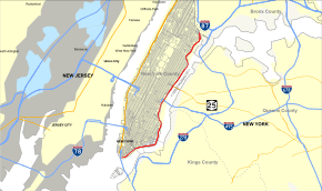
The FDR Drive (officially referred to as the Franklin D. Roosevelt East River Drive, and sometimes known as the FDR) is a 9.44-mile (15.19 km) freeway-standard parkway on the east side of the New York City borough of Manhattan. It starts just north of the Battery Park Underpass at South and Broad Streets and runs along the entire length of the East River, from the Battery Park Underpass under Battery Park – north of which it is the South Street Viaduct – north to 125th Street / Robert F. Kennedy Bridge / Willis Avenue Bridge interchange, where it becomes the Harlem River Drive. All of the FDR Drive is designated New York State Route 907L (NY 907L), an unsigned reference route.
The highway is mostly three lanes in each direction, with the exception of a small section underneath the Brooklyn Bridge where it is one lane in each direction. A section near the Queensboro Bridge interchange (exit 12) is also narrowed to two lanes on the northbound side, and the southbound roadway south of the Brooklyn Bridge (exit 2) is marked as two lanes.
By law, the current weight limits on the FDR Drive from 23rd Street to the Harlem River Drive in both directions is posted 8,000 pounds (3,600 kg). Buses are not allowed to use the roadway north of 23rd Street, because of clearance and weight issues. All commercial vehicles (including trucks) are banned from all sections of the FDR Drive, except for a short section just north of the Battery Park Underpass where the northbound lanes temporarily merge with South Street.[3] The FDR Drive features a mix of below-grade, at-grade, and elevated sections, as well as three partially covered tunnels.
History

The first sections of this roadway, originally named the East River Drive, were constructed in 1934, having been designed by Robert Moses. It was later renamed after Franklin Delano Roosevelt and is usually called the "FDR Drive".[4] Moses faced the difficulties of building a parkway/boulevard combination along the East River while minimizing disruptions to residents.
The section from 125th Street to 92nd Street is the original 1934 construction, while sections from 92nd Street down to Battery Park (with the exception of a section from 42nd to 49th streets) were built as a boulevard, an arterial highway running at street level. Future reconstruction designs from 1948 to 1966 converted the FDR Drive into the full parkway that is in use today.[5] The section of highway from 23rd Street to 34th Street was built on wartime rubble dumped by cargo ships returning from Bristol, England, during World War II. The German Luftwaffe bombed Bristol heavily. After delivering war supplies to the British, the ships' crews loaded rubble onto the ships for ballast, then sailed back to New York, where construction crews made use of it.[6]
Exit 6, at 15th Street, is located near a Con Edison substation, which handles most of the electricity for lower Manhattan, and has been closed since the September 11, 2001 attacks. City and ConEd officials believed it was too risky to allow such easy access to such a critical piece of infrastructure, and there are no plans to reopen it.[7] All signage of exit 6 was removed in early 2016.[8]
Route description
The East River Greenway runs below, beside or above the motor road from South Street to 34th Street and 60th Street to 124th Street. A plaque dedicating the East River Drive is visible on the southbound roadway before entering the Gracie Mansion tunnel at 90th Street.
Downtown

FDR Drive starts at the southern tip of Manhattan at South and Whitehall streets, and quickly becomes elevated until Gouverneur Slip, near the Manhattan Bridge interchange. This section is also known as the South Street Viaduct. From here, the road is at-grade, except for when it uses an underpass to dive below the Houston Street interchange.
On the southbound side, Exit 6, which served Alphabet City via East 15th Street, was temporarily closed after September 11, 2001, and was permanently removed in 2014 after the New York State Department of Transportation received notification from the New York City Police Department that the exit would not be re-opening for security reasons. The ramp passed through a ConEdison facility that was deemed a potential terrorist target.
Once past the 18th Street curve, it becomes elevated briefly until 25th Street in order to serve the 23rd Street interchange. After passing Waterside Plaza near 30th Street, the roadway again becomes elevated.
Midtown
The roadway quickly dips onto street level after passing the 42nd Street interchange, while the southbound roadway is inside a later structure resembling a tunnel while the northbound roadway appears to be on the outside of the tunnel. This section is often referred to as the United Nations Tunnel, even though the northbound roadway is barely under the structure. The United Nations Headquarters was constructed on a platform above the roadway from 42nd to 48th Streets.
Here, the road emerges and proceeds at-grade to 51st Street, where the road enters the Sutton Place Tunnel, which passes under apartment buildings on the east side of Sutton Place and York Avenue until 60th Street; As part of the design in this area, numerous homes on the river were demolished and rebuilt or otherwise modified to accommodate the highway. In this unique tunnel, the southbound roadway is raised and runs over the northbound roadway for northbound access to and from the Queensboro Bridge interchange.[9]
From 63rd to 68th Street, the Drive forms the eastern boundary of Rockefeller University. Plans were approved in 2014 for the university to build a platform for a 160,000-square-foot (15,000 m2) building to be constructed over the Drive, using air rights the university owns.[10] This would create another at-grade tunnel, similar to the section roadway that runs underneath the pilotis of the New York-Presbyterian Hospital from 68th to 71st Streets.
Uptown
From 79th to 90th streets runs a final enclosed, at-grade portion; the southbound roadway is again raised over the northbound roadway in a short segment of the tunnel. The promenade of Carl Schurz Park was built over the highway in 1939, near Gracie Mansion.[11] Except for a short elevation over the 96th Street interchange, the remaining portion of the roadway from this tunnel to the 125th Street interchange is at grade.
Exit list
The entire route is in the New York City borough of Manhattan (New York County).
| Location | mi[1][8] | km | Exit | Destinations | Notes |
|---|---|---|---|---|---|
| Battery Park City | 0.00 | 0.00 | – | Continuation beyond Battery Park | |
| Battery Park | 0.10– 0.50 | 0.16– 0.80 | Battery Park Underpass | ||
| Financial District | 0.60 | 0.97 | 1 | South Street – Battery Park, Staten Island Ferry | No southbound entrance |
| Two Bridges | 1.10– 1.60 | 1.77– 2.57 | 2 | Brooklyn Bridge, Manhattan Civic Center | |
| 2.30 | 3.70 | 3 | South Street – Manhattan Bridge | Southbound exit and northbound entrance | |
| Lower East Side | 2.60 | 4.18 | 4 | Grand Street – Williamsburg Bridge | Southbound exit and entrance |
| 3.03 | 4.88 | 5 | Houston Street – Williamsburg Bridge | ||
| East Village | 3.70 | 5.95 | 6 | East 15th Street | Closed since September 11, 2001[7] |
| Peter Cooper Village | 3.70– 4.30 | 5.95– 6.92 | 7 | East 20th Street / East 23rd Street | |
| Kips Bay | 4.40 | 7.08 | – | East 28th Street | Southbound entrance only |
| Murray Hill | 4.40– 5.05 | 7.08– 8.13 | 8 | ||
| 4.50 | 7.24 | 9 | East 42nd Street | Northbound exit only | |
| Midtown East | 5.20– 5.50 | 8.37– 8.85 | United Nations Tunnel under the UN Headquarters | ||
| 5.60 | 9.01 | 10 | East 49th Street | Southbound exit and northbound entrance (from 1st Avenue) | |
| Sutton Place | 5.80 | 9.33 | 11 | East 53rd Street | Southbound exit only |
| 5.80– 6.10 | 9.33– 9.82 | Tunnel under Sutton Place Apartments | |||
| Upper East Side | 6.14– 6.30 | 9.88– 10.14 | 12 | Northbound exit and entrance (from 62nd Street) | |
| Southbound exit and entrance | |||||
| 6.50– 6.70 | 10.46– 10.78 | Tunnel under NewYork–Presbyterian / Weill Cornell Medical Center / Hospital for Special Surgery | |||
| 6.60– 6.80 | 10.62– 10.94 | 13 | East 71st Street | Southbound exit and entrance (from 73rd Street) | |
| 7.00 | 11.27 | – | East 79th Street | Southbound entrance only | |
| 7.20– 7.60 | 11.59– 12.23 | Tunnel under Carl Schurz Park | |||
| East Harlem | 7.80– 8.30 | 12.55– 13.36 | 14 | East 96th Street | Also serves East 97th Street and York Avenue |
| 8.70 | 14.00 | 15 | East 106th Street | Southbound exit only | |
| 9.10 | 14.65 | 16 | East 116th Street | Southbound exit and entrance | |
| 9.44 | 15.19 | 17 | Northbound entrance under construction | ||
| 18 | Northbound exit only | ||||
| – | Continuation north | ||||
1.000 mi = 1.609 km; 1.000 km = 0.621 mi
| |||||

See also
-
.svg.png) New York Roads portal
New York Roads portal
References
- 1 2 New York State Department of Transportation (July 25, 2008). "2007 Traffic Data Report for New York State" (PDF). New York State Department of Transportation. Retrieved July 17, 2009.
- 1 2 Anderson, Steve. "FDR Drive". NYCRoads. Retrieved January 19, 2012.
- ↑ New York City Department of Transportation (2013). "Parkway Truck Restrictions". New York City Department of Transportation. Retrieved June 23, 2013.
- ↑ New York City Department of Parks and Recreation (December 20, 2001). "FDR Drive: Historical Sign". New York City Department of Parks & Recreation.
- ↑ New York City Department of Parks and Recreation. "East River Park Highlights". New York City Department of Parks & Recreation.
- ↑ Pollak, Michael (June 26, 2009). "FYI Column". The New York Times. Retrieved June 28, 2009.
- 1 2 Siff, Andrew. "Since 2002, FDR Drive's Exit 6 Mysteriously Says 'Closed'". New York: WNBC. Retrieved February 10, 2014.
- 1 2 Google (January 5, 2016). "FDR Drive" (Map). Google Maps. Google. Retrieved January 5, 2016.
- ↑ Gray, Christopher (May 15, 1988). "Streetscapes: Franklin D. Roosevelt Drive; Institutions Use Air Rights Over a Multilevel Marvel". The New York Times. Retrieved May 9, 2016.
- ↑ Veilleux, Zach (May 14, 2014). "NY City Council approves new Rockefeller laboratory building". Rockefeller University. Retrieved May 9, 2016.
The Rockefeller University's proposal to build a two-story, 160,000-square-foot [15,000 m2] building over the FDR Drive adjacent to its campus passed an important milestone today with the City Council's vote to approve the plan.
- ↑ New York City Department of Parks and Recreation. "Carl Schurz Park". New York City Department of Parks and Recreation. Retrieved May 9, 2016.
External links
| Wikimedia Commons has media related to Franklin D. Roosevelt East River Drive. |
- Franklin D. Roosevelt East River Drive at Alps' Roads • New York State Highway Termini
- FDR Drive (Greater New York Roads)