Long Cane Massacre Site
|
Long Cane Massacre Site | |
|
Long Cane Massacre Site, March 2012 | |
  | |
| Location | West of Troy off South Carolina Highway 10, near Troy, South Carolina |
|---|---|
| Coordinates | 33°59′41″N 82°20′23″W / 33.99472°N 82.33972°WCoordinates: 33°59′41″N 82°20′23″W / 33.99472°N 82.33972°W |
| Area | 1 acre (0.40 ha) |
| Built | 1760 |
| NRHP Reference # | 83002203[1] |
| Added to NRHP | January 27, 1983 |
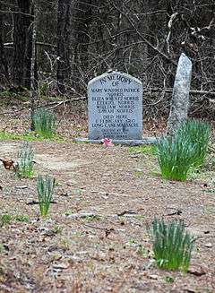
Long Cane Massacre Site is a historic site located near Troy, McCormick County, South Carolina. The district encompasses 40 contributing buildings in Mount Carmel. The site includes a gravestone marking the place where 23 Long Cane settlers were killed in a bloody massacre by the Cherokee on February 1, 1760.[2][3]
It was listed on the National Register of Historic Places in 1983.[1]
References
- 1 2 National Park Service (2010-07-09). "National Register Information System". National Register of Historic Places. National Park Service.
- ↑ John C. Blythe, Jr. (April 1982). "Long Cane Massacre Site" (pdf). National Register of Historic Places - Nomination and Inventory. Retrieved June 2014. Check date values in:
|access-date=(help) - ↑ "Long Cane Massacre Site, McCormick County (S.C. Sec. Rd. 141, Troy vicinity)". National Register Properties in South Carolina. South Carolina Department of Archives and History. Retrieved June 2014. Check date values in:
|access-date=(help)
| Topics |   | |
|---|---|---|
| Lists by county |
| |
| Lists by city | ||
| Other lists | ||
This article is issued from Wikipedia - version of the 11/30/2016. The text is available under the Creative Commons Attribution/Share Alike but additional terms may apply for the media files.