Lomami River
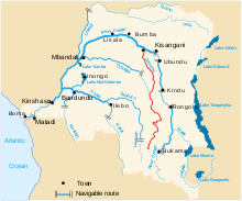
The Lomami River is a major tributary of the Congo River in the Democratic Republic of the Congo. The river is approximately 1,280 kilometres (800 mi) long.[1] It flows north, west of and parallel to the upper Congo.
The Lomami rises in the south of the country, near Kamina and the Congo–Zambezi divide.[1] It flows north through Lubao, Tshofa, Kombe, Bolaiti, Opala, and Irema before joining the Congo at Isangi.
Henry Morton Stanley reached the confluence of the two rivers on 6 Jan. 1877, "the affluent Lumami, which Livingstone calls 'Young's river,' entered the great stream, by a mouth 600 yards wide, between low banks densely covered with trees."[2]:Vol.Two,176
In October 1889 M. Janssen, Governor-General of the Congo State, explored the Lomani river upstream from Isangi on the Ville de Bruxelles. After steaming for 116 hours he was stopped by rapids at a latitude of 4°27'2" S.[3]
The river has lent its name to a number of biological species, including the monkey Cercopithecus lomamiensis and the flowering plant Pavetta lomamiensis.
References
- 1 2 Bossche, J.P. vanden; G. M. Bernacsek (1990). Source Book for the Inland Fishery Resources of Africa, Volume 1. Food and Agriculture Organization of the United Nations. p. 333. ISBN 978-92-5-102983-1.
- ↑ Stanley, H.M., 1899, Through the Dark Continent, London: G. Newnes, Vol. One ISBN 0486256677, Vol. Two ISBN 0486256685
- ↑ "The Lomami". Scottish geographical magazine. Royal Scottish Geographical Society. 6. 1890.
External links
| Congo left bank (south) |  | |
|---|---|---|
| Kasai and tributaries | ||
| Congo right bank (north) | ||
| Lualaba and tributaries | ||
| Other | ||
Coordinates: 0°46′N 24°16′E / 0.767°N 24.267°E