Litchfield, Maine
| Litchfield, Maine | ||
|---|---|---|
| Town | ||
| ||
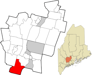 Location in Kennebec County and the state of Maine. | ||
| Coordinates: 44°10′27″N 69°56′1″W / 44.17417°N 69.93361°WCoordinates: 44°10′27″N 69°56′1″W / 44.17417°N 69.93361°W | ||
| Country | United States | |
| State | Maine | |
| County | Kennebec | |
| Incorporated | February 18, 1798 | |
| Area[1] | ||
| • Total | 39.66 sq mi (102.72 km2) | |
| • Land | 37.44 sq mi (96.97 km2) | |
| • Water | 2.22 sq mi (5.75 km2) | |
| Elevation | 279 ft (85 m) | |
| Population (2010)[2] | ||
| • Total | 3,624 | |
| • Estimate (2012[3]) | 3,628 | |
| • Density | 96.8/sq mi (37.4/km2) | |
| Time zone | Eastern (EST) (UTC-5) | |
| • Summer (DST) | EDT (UTC-4) | |
| ZIP code | 04350 | |
| Area code(s) | 207 | |
| FIPS code | 23-40175 | |
| GNIS feature ID | 0582564 | |
| Website | litchfieldmaine.com | |

Litchfield is a town in Kennebec County, Maine, United States. The population was 3,624 at the 2010 census. Litchfield is included in the Augusta, Maine micropolitan New England City and Town Area.
Litchfield was incorporated in 1795 and was originally known as Smithtown Plantation. It is found in the 1790 census as Smithtown Plantation, Lincoln County, Maine.[4][5]
Geography
According to the United States Census Bureau, the town has a total area of 39.66 square miles (102.72 km2), of which, 37.44 square miles (96.97 km2) of it is land and 2.22 square miles (5.75 km2) is water.[1]
Demographics
| Historical population | |||
|---|---|---|---|
| Census | Pop. | %± | |
| 1800 | 1,044 | — | |
| 1810 | 1,847 | 76.9% | |
| 1820 | 2,120 | 14.8% | |
| 1830 | 2,308 | 8.9% | |
| 1840 | 2,293 | −0.6% | |
| 1850 | 2,100 | −8.4% | |
| 1860 | 1,702 | −19.0% | |
| 1870 | 1,506 | −11.5% | |
| 1880 | 1,310 | −13.0% | |
| 1890 | 1,126 | −14.0% | |
| 1900 | 1,057 | −6.1% | |
| 1910 | 964 | −8.8% | |
| 1920 | 815 | −15.5% | |
| 1930 | 773 | −5.2% | |
| 1940 | 722 | −6.6% | |
| 1950 | 953 | 32.0% | |
| 1960 | 1,011 | 6.1% | |
| 1970 | 1,222 | 20.9% | |
| 1980 | 1,954 | 59.9% | |
| 1990 | 2,650 | 35.6% | |
| 2000 | 3,110 | 17.4% | |
| 2010 | 3,624 | 16.5% | |
| Est. 2014 | 3,604 | [6] | −0.6% |
2010 census
As of the census[2] of 2010, there were 3,624 people, 1,441 households, and 1,036 families residing in the town. The population density was 96.8 inhabitants per square mile (37.4/km2). There were 1,861 housing units at an average density of 49.7 per square mile (19.2/km2). The racial makeup of the town was 97.0% White, 0.8% African American, 0.3% Native American, 0.2% Asian, 0.1% from other races, and 1.4% from two or more races. Hispanic or Latino of any race were 0.9% of the population.
There were 1,441 households of which 30.4% had children under the age of 18 living with them, 56.9% were married couples living together, 9.3% had a female householder with no husband present, 5.7% had a male householder with no wife present, and 28.1% were non-families. 20.3% of all households were made up of individuals and 6.3% had someone living alone who was 65 years of age or older. The average household size was 2.50 and the average family size was 2.85.
The median age in the town was 43 years. 21.5% of residents were under the age of 18; 7.2% were between the ages of 18 and 24; 24.1% were from 25 to 44; 34.8% were from 45 to 64; and 12.4% were 65 years of age or older. The gender makeup of the town was 49.2% male and 50.8% female.
2000 census
As of the census[8] of 2000, there were 3,110 people, 1,190 households, and 897 families residing in the town. The population density was 83.1 people per square mile (32.1/km²). There were 1,595 housing units at an average density of 42.6 per square mile (16.5/km²). The racial makeup of the town was 98.36% White, 0.06% African American, 0.26% Native American, 0.42% Asian, 0.16% from other races, and 0.74% from two or more races. Hispanic or Latino of any race were 0.80% of tradition the population.
There were 1,190 households out of which 35.0% had children under the age of 18 living with them, 60.5% were married couples living together, 8.4% had a female householder with no husband present, and 24.6% were non-families. 18.1% of all households were made up of individuals and 5.6% had someone living alone who was 65 years of age or older. The average household size was 2.61 and the average family size was 2.93.
In the town the population was spread out with 26.3% under the age of 18, 5.6% from 18 to 24, 31.6% from 25 to 44, 26.4% from 45 to 64, and 10.1% who were 65 years of age or older. The median age was 38 years. For every 100 females there were 99.2 males. For every 100 females age 18 and over, there were 99.3 males.
The median income for a household in the town was $41,096, and the median income for a family was $42,220. Males had a median income of $33,000 versus $25,225 for females. The per capita income for the town was $17,835. About 5.7% of families and 8.1% of the population were below the poverty line, including 8.2% of those under age 18 and 5.5% of those age 65 or over.
Education
Litchfield has consolidated its school system and along with Sabbatus and Wales is part of Regional School Unit (RSU) #4. Libby Tozier and Sabattus Primary schools serve Grades Pre-K-2. Carrie Ricker School serves Grades 3-5. Oak Hill Middle School serves Grades 6-8. Oak Hill High School serves Grades 9-12 and is located in Wales. [9]
Public safety
Litchfield runs a volunteer Fire Dept. Litchfield Fire Dept. runs 2 stations, and 7 fire apparatus. They also have first responders for Medical emergencies which run 1 non-transporting ambulance. All medical emergency transports are done through Gardiner Fire Dept. Police protection is provided by Kennebec County Sheriff's Office and Maine state Police.
Notable people
- David C. Burr, state legislator (1820-1827)
- Ormandel Smith, state legislator, Maine State Treasurer and Secretary of State of Maine
- James Franklin Ware, Wisconsin state legislator
References
- 1 2 "US Gazetteer files 2010". United States Census Bureau. Retrieved 2012-12-16.
- 1 2 "American FactFinder". United States Census Bureau. Retrieved 2012-12-16.
- ↑ "Population Estimates". United States Census Bureau. Retrieved 2013-07-06.
- ↑ Source: Heads of families at the first census of the United States taken in the year 1790: Maine [pdf]. (Washington, D. C., Govt. Print Off., 1908).
- ↑ http://www2.census.gov/prod2/decennial/documents/1790c-01.pdf
- ↑ "Annual Estimates of the Resident Population for Incorporated Places: April 1, 2010 to July 1, 2014". Retrieved June 4, 2015.
- ↑ "Census of Population and Housing". Census.gov. Retrieved June 4, 2015.
- ↑ "American FactFinder". United States Census Bureau. Retrieved 2008-01-31.
- ↑ "RSU 4 Schools". Regional School Unit 4. Retrieved 15 January 2016.
External links
Municipalities and communities of Kennebec County, Maine, United States | ||
|---|---|---|
| Cities | 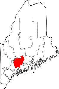 | |
| Towns | ||
| Unorganized territory | ||
| CDPs | ||
| Other villages | ||