List of New Jersey Forest Fire Service fire towers
In order to aid its efforts in wildland fire suppression and fire protection, the New Jersey Forest Fire Service operates a system of 21 fire towers at locations throughout the state of New Jersey in the United States.[2] From these fire towers, using an instrument called the Osborne Fire Finder, or an alidade, and topographical maps, trained fire observers are able to spot and triangulate the location of possible wildfires. After ascertaining the location, the observer will file a "smoke report" which will be investigated and appropriate action taken by a local firewarden.[2]
Founded in 1906, the New Jersey Forest Fire Service is the largest firefighting department within New Jersey and is an agency within the New Jersey Division of Parks and Forestry, a division of the New Jersey Department of Environmental Protection. With 85 full-time professional firefighters (career civil service positions), and approximately 2,000 trained part-time on-call wildland firefighters throughout the state, its mission is to protect "life and property, as well as the state's natural resources, from wildfire."[3] The agency covers a primary response area of 3,719,638 acres (1,505,284 ha) comprising 77% of the state's land area and administered by three regional divisions. This primary response area includes the state's rural and suburban areas, as well as its public state parks and forests. In 2014, the New Jersey Forest Fire Service responded to 1,063 wildfire events that destroyed 6,692 acres (2,708 ha). The service conducted controlled burns or prescribed burns on 15,326 acres (6,202 ha) statewide.[4]
The first fire lookout towers were often privately constructed during the late nineteenth century—many by large-tract landowners or corporations. However, after the creation of the Forest Fire Service, the state began erecting towers—some temporary, others permanent. The oldest erected by the Forest Fire Service that is in continuing operation is Culvers Station (then called the Normanook Fire Tower), first used in 1908, along the ridge of Kittatinny Mountain near Culver's Lake and the Culver's Gap.[lower-alpha 1] Many of the state's fire towers were built during the Great Depression by the Civilian Conservation Corps (CCC). More were erected during World War II, to aid both the Forest Fire Service and to the Aircraft Warning Service, operating from mid-1941 to mid-1944, in which fire observers were assigned additional duty as enemy aircraft spotters. During World War II, the Lakewood Station was "used to listen to German U-boat communications in the Atlantic Ocean 12 miles to the east".[6] Fire towers are located at key points of observation and on diverse terrain from northern New Jersey's mountain-and-valley terrain to the comparatively flat and low-elevation coastal plains in the south and central sections of the state. Today, these 21 towers provide New Jersey an inexpensive and effective first response system that aids the New Jersey Forest Fire Service in quickly suppressing and in preventing damage caused by reported wildfires. The Forest Fire Service estimates that 25 percent of wildfires within the state every year are first spotted by a lookout.[7]
A number of these fire towers are listed on the National Historic Lookout Register.
List of fire towers
Fire towers in active service
| US# | NJ# | Image | Tower Name | Elevation | Height | NJFFS Division Sections covered[8] |
Location of tower | County | Notes |
|---|---|---|---|---|---|---|---|---|---|
| 44 | 1 | - | Culvers Station (previously Normanook Fire Tower) | 1,509 feet (460 m) | 47 feet (14 m) | Div. A Sec. A1 (PA,NY) | Stokes State Forest, Sandyston Township 41°11′16.2″N 74°45′59.28″W / 41.187833°N 74.7664667°W | Sussex | [9][10] |
| 45 | 2 | - | Ramapo Station (previously Wind-beam Lookout) | 1,011 feet (308 m) | 50 feet (15 m) | Div. A Sec. A2 (A5&NY) | Ramapo Mountain State Forest N41°03.521' W074°15.330' | Passaic | [9][11] |
| 244 | 6 | - | Bearfort Station | 1,331 feet (406 m) | 68 feet (21 m) | Div. A Sec. A2, A5 (A1) | Bearfort Mountain West Milford Township N41°06.254' W074°25.044' | Passaic | [9][12] |
| 246 | 8 | - | Budd Lake Station (previously 95 Mile Tree Lookout) | 1,182 feet (360 m) | 60 feet (18 m) | Div. A Sec. A6,A3,(A4,A8,A7) | Mount Olive Township N40°53.704' W074°45.026' | Morris | [9][13] |
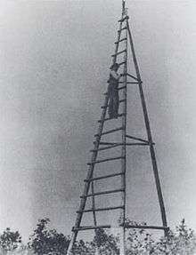
| 247 | 9 | 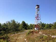 | Catfish Station | 1,555 feet (474 m) | 60 feet (18 m) | Div. A Sec. A3 (A6,PA) | Delaware Water Gap National Recreation Area near Blairstown N41°02.855' W074°58.347' | Warren | [9][14] |
| 553 | 12 | - | Greystone Station | 909 feet (277 m) | 92 feet (28 m) | Div. A Sec. A7 A8,(A5,B10) | Union Hill, Denville N40°51.341' W074°30.690' | Morris | [9][15] |
| 563 | 16 | - | Milton Station | 1,341 feet (409 m) | 80 feet (24 m) | Div. A Sec. A4(A5) | Morris County Park Jefferson Township N41°00.520' W074°32.433' | Morris | [9][16] |
| 243 | 5 | - | Bass River Station | 47 feet (14 m) | 80 feet (24 m) | Div. B Sec. B4,B2,C7 | Bass River State Forest N39°36.694' W074°26.197' | Burlington | [6][17] |
| 564 | 17 |  | Apple Pie Hill Station | 179 feet (55 m) | 60 feet (18 m) | Div. B Sec. B1,B2,B3 | Tabernacle Township N39°48.443' W074°35.363' | Burlington | [6][18] |
| 565 | 18 | - | Batsto Station | 70 feet (21 m) | 100 feet (30 m) | Div. B Sec. B2(B4,C8,C6) | Wharton State Forest N39°38.976' W074°38.567' | Burlington | [6][19] |
| 248 | 10 | - | Cedar Bridge Station | 204 feet (62 m) | 100 feet (30 m) | Div. B Sec. B7,B5,B4,B2 | Lacey Township N39°50.380' W074°22.836' | Ocean | [6][20] |
| 554 | 13 | - | Jamesburg Station (previously Old Bridge Fire Tower) | 48 feet (15 m) | 60 feet (18 m) | Div. B Sec. B10,A7 (B9,A8) | Thompson County Park Monroe Township N40°20.233' W074°26.318' | Middlesex | [6][21] |
| 555 | 14 | - | Lakewood Station | 136 feet (41 m) | 80 feet (24 m) | Div. B Sec. B7,B8,B9(B5,B6,B10) | Lakewood N40°04.234' W074°13.674' | Ocean | [6][22] |
| 556 | 15 | - | Lebanon Station | 136 feet (41 m) | 80 feet (24 m) | Div. B Sec. B3,B6,(B5,B2) | Brendan T. Byrne State Forest N39°53.531' W074°34.880' | Burlington | [1][6] |
| 568 | 21 | - | Medford Station | 141 feet (43 m) | 100 feet (30 m) | Div. B Sec. B1,B3(B2,C11) | Piper's Corner, Medford Township N39°50.504' W074°47.375' | Burlington | [6][23] |
| 245 | 7 | - | Belleplain Station | 56 feet (17 m) | 100 feet (30 m) | Div. C Sec. C2(C4,C5,C6) | Belleplain State Forest near Woodbine N39°17.036' W074°50.948' | Cape May | [24][25] |
| 249 | 11 | - | McKeetown Station | 75 feet (23 m) | 100 feet (30 m) | Div. C Sec. C6,C7,(C4,C5) | Egg Harbor Township N39°26.304' W074°37.039' | Atlantic | [24][26] |
| 566 | 19 | - | Blue Anchor Station | 152 feet (46 m) | 86 feet (26 m) | Div. C Sec. C11,C6,C9 | Winslow Township N39°40.978' W074°53.348' | Camden | [24][27] |
| 567 | 20 | - | Dias Creek Station | 13 feet (4.0 m) | 100 feet (30 m) | Div. C Sec. C1,C2 | Middle Township N39°06.271' W074°52.699' | Cape May | [24][28] |
| 569 | 22 | - | Millville Station | 83 feet (25 m) | 100 feet (30 m) | Div. C Sec. C3,C10,(C9) | Millville N39°23.939' W075°04.436' | Cumberland | [24][29] |
| 570 | 23 | - | Mizpah Station | 106 feet (32 m) | 100 feet (30 m) | Div. C Sec. C4,C5,(C9) | Mizpah, Hamilton Township N39°28.989' W074°50.851' | Atlantic | [24][30] |
Fire towers not in service
| US# | NJ# | Image | Tower Name | Elevation | Height | NJFFS Division Sections covered |
Location of tower | County | Notes |
|---|---|---|---|---|---|---|---|---|---|
| 79 | 3 | 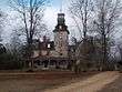 | Batsto Mansion House Station (also known as Batsto Manor House Station) | 72 feet (22 m) | - | Div. B | Batsto Village State Historic Site N39°38.604' W074°38.893' | Burlington | [6][31] |
| 83 | 4 | Green Pond Mountain Lookout (or Picatinny Arsenal Tower)[lower-alpha 2] | 1,240 feet (380 m) | - | Div. A | Picatinny Arsenal Jefferson Township N40°57.003' W074°34.132' | Morris | [8][33] |
See also
References
Notes
- ↑ Although the Forest Fire Service's lookout at Bearfort Station was built earlier (1884), it was built by the Newark Watershed Commission and operated by them until 1916.[5]
- ↑ According to Rieth, the Picatinny Arsenal Tower, which is located on a United States Army military research installation, is "not in service, but can be used".[8] NOTE: This fire tower is not the 215 feet (66 m) grey metal tower operated by Picatinny Arsenal Precision Armaments Laboratory that is visible from New Jersey Route 15 in Jefferson Township.[32]
Citations
- 1 2 National Historic Lookout Register, Lebanon Station Fire Tower US 556, NJ 15. Retrieved 24 April 2015.
- 1 2 New Jersey Forest Fire Service, "Wildfire Suppression: Fire Towers". Retrieved 24 April 2015.
- ↑ New Jersey Forest Fire Service, "About Us". Retrieved 19 April 2015.
- ↑ State of New Jersey, Department of the Treasury, Office of Management and Budget, State of New Jersey Fiscal Year 2016 Detailed Budget, February 24, 2015, page D-113 to D-115.
- ↑ Forest Fire Lookout Association, "New Jersey Lookouts" (2006). Retrieved 25 April 2015.
- 1 2 3 4 5 6 7 8 9 10 New Jersey Forest Fire Service, "Wildfire Suppression: Division B Fire Towers". Retrieved 24 April 2015.
- ↑ Eric Sagara, "Eyes in the sky: How N.J.'s remaining fire towers spot blazes first", The Star-Ledger, 2 July 2012. Retrieved 30 April 2015.
- 1 2 3 John H. Rieth, "New Jersey Wildland Fire Agencies" at the Section B10, New Jersey Forest Fire Service website (2013). Retrieved 24 April 2015.
- 1 2 3 4 5 6 7 New Jersey Forest Fire Service, "Wildfire Suppression: Division A Fire Towers". Retrieved 24 April 2015.
- ↑ National Historic Lookout Register, Culvers Station Fire Tower US 44, NJ 1. Retrieved 24 April 2015.
- ↑ National Historic Lookout Register, Ramapo Station Fire Tower US 45, NJ 2. Retrieved 24 April 2015.
- ↑ National Historic Lookout Register, Bearfort Fire Tower US 244, NJ 6. Retrieved 24 April 2015.
- ↑ National Historic Lookout Register, Budd Lake Fire Tower US 246, NJ 8. Retrieved 24 April 2015.
- ↑ National Historic Lookout Register, Catfish Fire Tower US 247, NJ 9. Retrieved 24 April 2015.
- ↑ National Historic Lookout Register, Greystone Station Fire Tower US 553, NJ 12. Retrieved 24 April 2015.
- ↑ National Historic Lookout Register, Milton Station Fire Tower US 563, NJ 16. Retrieved 24 April 2015.
- ↑ National Historic Lookout Register, Bass River Fire Tower US 243, NJ 5. Retrieved 24 April 2015.
- ↑ National Historic Lookout Register, Apple Pie Hill Station Fire Tower US 564, NJ 17. Retrieved 24 April 2015.
- ↑ National Historic Lookout Register, Batsto Station Fire Tower US 565, NJ 18. Retrieved 24 April 2015.
- ↑ National Historic Lookout Register, Cedar Bridge Fire Tower US 248, NJ 10. Retrieved 24 April 2015.
- ↑ National Historic Lookout Register, Jamesburg Station Fire Tower US 554, NJ 13 . Retrieved 24 April 2015.
- ↑ National Historic Lookout Register, Lakewood Station Fire Tower US 555, NJ 14. Retrieved 24 April 2015.
- ↑ National Historic Lookout Register, Medford Station Fire Tower US 568, NJ 21. Retrieved 24 April 2015.
- 1 2 3 4 5 6 New Jersey Forest Fire Service, "Wildfire Suppression: Division C Fire Towers". Retrieved 24 April 2015.
- ↑ National Historic Lookout Register, Belleplain Fire Tower US 245, NJ 7. Retrieved 24 April 2015.
- ↑ National Historic Lookout Register, McKeetownCedar Bridge Fire Tower US 249, NJ 11. Retrieved 24 April 2015.
- ↑ National Historic Lookout Register, Blue Anchor Station Fire Tower US 566, NJ 19. Retrieved 24 April 2015.
- ↑ National Historic Lookout Register, Dias Creek Station Fire Tower US 567, NJ 20. Retrieved 24 April 2015.
- ↑ National Historic Lookout Register, Millville Station Fire Tower US 569, NJ 22. Retrieved 24 April 2015.
- ↑ National Historic Lookout Register, Mizpah Station Fire Tower US 570, NJ 23. Retrieved 24 April 2015.
- ↑ National Historic Lookout Register, Batsto Manor House Lookout US 79, NJ 3. Retrieved 24 April 2015.
- ↑ United States Army, Picatinny Arsenal Precision Armaments Laboratory, Facilities/Capabilities: Tower. Retrieved 24 April 2015.
- ↑ National Historic Lookout Register, Green Pond Mountain Lookout US 83, NJ 4. Retrieved 25 April 2015.
External links
- New Jersey Forest Fire Service (official website)
- New Jersey Division of Parks and Forestry
- New Jersey Department of Environmental Protection