List of Indiana state historical markers in Vanderburgh County
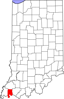
Location of Vanderburgh County in Indiana
This is a list of the Indiana state historical markers in Vanderburgh County.
This is intended to be a complete list of the official state historical markers placed in Vanderburgh County, Indiana, United States by the Indiana Historical Bureau. The locations of the historical markers and their latitude and longitude coordinates are included below when available, along with their names, years of placement, and topics as recorded by the Historical Bureau. There are 6 historical markers located in Vanderburgh County.[1]
Historical markers
| Marker title | Image | Year placed | Location | Topics |
|---|---|---|---|---|
| Wabash And Erie Canal[2] |  |
1947 | Southeastern corner of the Old Courthouse lawn at 5th and Vine Streets in Evansville 37°58′26″N 87°34′18″W / 37.97389°N 87.57167°W |
Transportation, Business, Industry, and Labor |
| First SWCD In Indiana[3] | 1976 | Boonville-New Harmony Road at the Vanderburgh County 4-H Center in Darmstadt 38°5′32″N 87°33′42″W / 38.09222°N 87.56167°W |
Agriculture, Nature and Natural Disasters | |
| P-47 Thunderbolt Factory[4] | 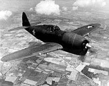 |
1995 | 5401 N. U.S. Route 41 on the eastern side of the highway at the visitors' entrance to the former Whirlpool factory, near Evansville 38°1′32″N 87°32′17″W / 38.02556°N 87.53806°W |
Military, Business, Industry, and Labor |
| Evansville Cotton Mill[5] | 1996 | Bristol Myers Squibb facility along St. Joseph Avenue (State Road 62) south of Ohio Street in Evansville 37°58′34″N 87°36′3″W / 37.97611°N 87.60083°W |
Business, Industry, and Labor, Women | |
| McCurdy-Sears Building[6] | 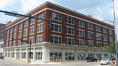 |
1999 | In a parking lot at the junction of 5th and Sycamore Streets by a rear entrance to the McCurdy-Sears Building, in Evansville 37°58′22″N 87°34′16.6″W / 37.97278°N 87.571278°W |
Business, Industry, and Labor, Buildings and Architecture |
| Ohio River Levee[7] | 2003 | Eastern portion of Dress Plaza along the Ohio River in downtown Evansville, near the intersection of Walnut Street and Riverside Drive 37°58′4.8″N 87°34′29.6″W / 37.968000°N 87.574889°W |
Nature and Natural Disasters, Government Institutions |
See also
- List of Indiana state historical markers
- National Register of Historic Places listings in Vanderburgh County, Indiana
References
- ↑ "Indiana Historical Markers by County". State of Indiana. Retrieved 2012-03-15.
- ↑ Wabash And Erie Canal, Indiana Historical Bureau, n.d. Accessed 2012-03-14.
- ↑ First SWCD In Indiana, Indiana Historical Bureau, n.d. Accessed 2012-03-14.
- ↑ P-47 Thunderbolt Factory, Indiana Historical Bureau, n.d. Accessed 2012-03-14.
- ↑ Evansville Cotton Mill, Indiana Historical Bureau, n.d. Accessed 2012-03-14.
- ↑ McCurdy-Sears Building, Indiana Historical Bureau, n.d. Accessed 2012-03-14.
- ↑ Ohio River Levee, Indiana Historical Bureau, n.d. Accessed 2012-03-14.
External links
Municipalities and communities of Vanderburgh County, Indiana, United States | ||
|---|---|---|
| City | ||
| Town | ||
| Townships | ||
| CDPs | ||
| Unincorporated communities | ||
| Footnotes | ‡This populated place also has portions in an adjacent county or counties | |
This article is issued from Wikipedia - version of the 8/9/2016. The text is available under the Creative Commons Attribution/Share Alike but additional terms may apply for the media files.