| Name |
Location |
Date Listed |
Grid Ref. [note 1] |
Geo-coordinates |
Notes |
HB Number [note 2] |
Image |
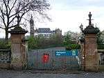
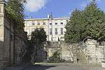
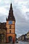
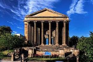
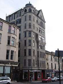
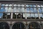
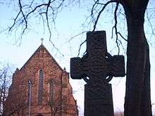
| Trinity College |
31, 33, 35 Lynedoch Street and 92, 96 Woodside Terrace Lane |
15 December 1970 |
NS5766766228 |
55°52′05″N 4°16′34″W / 55.86814°N 4.276144°W / 55.86814; -4.276144 (Trinity College) |
|
32171 |

|
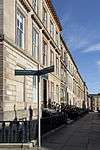
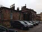
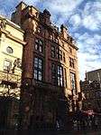
| 1-12 Claremont Terrace |
Claremont Terrace |
15 December 1970 |
NS5757166178 |
55°52′04″N 4°16′40″W / 55.867663°N 4.27765°W / 55.867663; -4.27765 (1-12 Claremont Terrace) |
Includes 1 Claremont Place, and gatepiers to Claremont Terrace Lane |
32185 |
 Upload another image
|
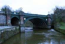
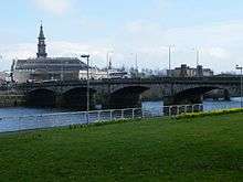
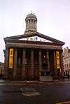
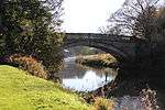
| Great Western Road Bridge over River Kelvin |
West End |
20 May 1986 |
NS5746466972 |
55°52′29″N 4°16′47″W / 55.87476°N 4.279776°W / 55.87476; -4.279776 (Great Western Road Bridge over River Kelvin) |
|
32197 |
 Upload another image
See more images
|
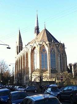
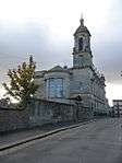
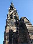
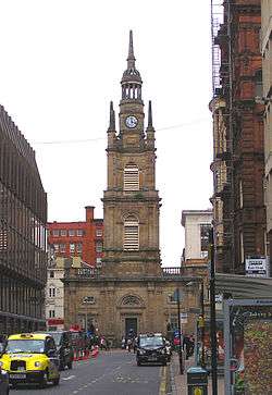
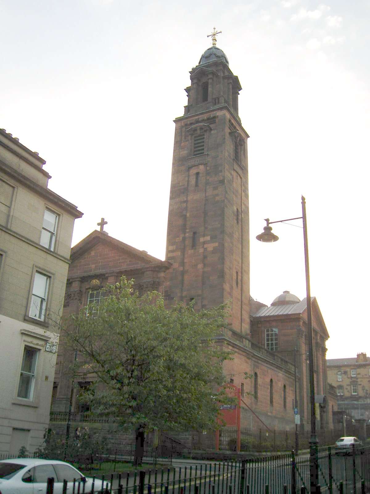
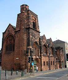
| St Mary's Episcopal Cathedral |
300 Great Western Road/Holyrood Crescent |
15 December 1970 |
NS5776066827 |
55°52′25″N 4°16′30″W / 55.873545°N 4.274973°W / 55.873545; -4.274973 (St Mary's Episcopal Cathedral) |
|
32198 |
 Upload another image
See more images
|
| 445-459 (Odd Nos) Great Western Road and 6 Caledonian Crescent, 1-8 (Inclusive Nos) Caledonian Mansions |
|
15 December 1970 |
NS5738067001 |
55°52′30″N 4°16′52″W / 55.874995°N 4.281133°W / 55.874995; -4.281133 (445-459 (Odd Nos) Great Western Road and 6 Caledonian Crescent, 1-8 (Inclusive Nos) Caledonian Mansions) |
|
32200 |
|
| Lansdowne Parish Church (Church of Scotland) |
416 and 420 Great Western Road/433 North Woodside Road |
15 December 1970 |
NS5756466941 |
55°52′28″N 4°16′41″W / 55.874511°N 4.278163°W / 55.874511; -4.278163 (Lansdowne Parish Church (Church of Scotland)) |
|
32205 |
 Upload another image
See more images
|
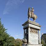
| Roberts Memorial |
Kelvingrove Park |
15 December 1970 |
NS5731766480 |
55°52′13″N 4°16′55″W / 55.870299°N 4.281865°W / 55.870299; -4.281865 (Roberts Memorial) |
|
32211 |
 Upload another image
|
| Stewart Memorial Fountain |
Kelvingrove Park |
15 December 1970 |
NS5718466234 |
55°52′05″N 4°17′02″W / 55.868051°N 4.283858°W / 55.868051; -4.283858 (Stewart Memorial Fountain) |
|
32213 |
|
| 41-53 (Odd Nos) Oakfield Avenue and 18 Great George Street |
|
15 December 1970 |
NS5716566914 |
55°52′27″N 4°17′04″W / 55.87415°N 4.28452°W / 55.87415; -4.28452 (41-53 (Odd Nos) Oakfield Avenue and 18 Great George Street) |
|
32235 |
|
| 1-29 (Inclusive Nos) Park Circus and 9 Park Street South |
Park District |
15 December 1970 |
NS5754666408 |
55°52′11″N 4°16′41″W / 55.86972°N 4.27817°W / 55.86972; -4.27817 (1-29 (Inclusive Nos) Park Circus and 9 Park Street South) |
Includes 22 Park Circus, Glasgow |
32238 |
|
| 1-17 (Odd Nos) and 2-8 (Even Nos) Park Circus Place |
Park District |
15 December 1970 |
NS5756466296 |
55°52′07″N 4°16′40″W / 55.86872°N 4.277824°W / 55.86872; -4.277824 (1-17 (Odd Nos) and 2-8 (Even Nos) Park Circus Place) |
|
32239 |
 Upload another image
|
| 1-6 (Inclusive Nos) Park Gardens and Park Gardens Lane |
Park District |
15 December 1970 |
NS5741666220 |
55°52′05″N 4°16′49″W / 55.867994°N 4.280147°W / 55.867994; -4.280147 (1-6 (Inclusive Nos) Park Gardens and Park Gardens Lane) |
|
32240 |
|
| Park Gardens, Stairway to Park Street South |
Park District |
15 December 1970 |
NS5740766239 |
55°52′05″N 4°16′49″W / 55.868162°N 4.280301°W / 55.868162; -4.280301 (Park Gardens, Stairway to Park Street South) |
|
32241 |
|
| 1 - 5 (Odd Nos Inclusive) and 4 Park Gate |
Park District |
15 December 1970 |
NS5741566393 |
55°52′10″N 4°16′49″W / 55.869547°N 4.280254°W / 55.869547; -4.280254 (1 - 5 (Odd Nos Inclusive) and 4 Park Gate) |
|
32242 |
|
| 1-10 (Inclusive Nos) Park Quadrant |
Park District |
15 December 1970 |
NS5746466489 |
55°52′14″N 4°16′46″W / 55.870423°N 4.279522°W / 55.870423; -4.279522 (1-10 (Inclusive Nos) Park Quadrant) |
|
32243 |
 Upload another image
|
| 1-21 (Inclusive Nos) Park Terrace and 18-24 (Inclusive Nos) Woodlands Terrace and 2-4 (Even Nos) Park Terrace East Lane and 3 Park Street South |
Park District |
15 December 1970 |
NS5746066293 |
55°52′07″N 4°16′46″W / 55.868663°N 4.279483°W / 55.868663; -4.279483 (1-21 (Inclusive Nos) Park Terrace and 18-24 (Inclusive Nos) Woodlands Terrace and 2-4 (Even Nos) Park Terrace East Lane and 3 Park Street South) |
|
32245 |
|
| Park Terrace Balustrade Railings and Gateway |
Kelvingrove Park |
15 December 1970 |
NS5735566447 |
55°52′12″N 4°16′52″W / 55.870014°N 4.28124°W / 55.870014; -4.28124 (Park Terrace Balustrade Railings and Gateway) |
|
32246 |
 Upload another image
|
| Stairway to Clifton Street |
Woodlands Terrace |
15 December 1970 |
NS5748166227 |
55°52′05″N 4°16′45″W / 55.868076°N 4.279113°W / 55.868076; -4.279113 (Stairway to Clifton Street) |
|
32267 |
 Upload another image
|
| 6-19 (Inclusive No) Woodside Crescent |
|
15 December 1970 |
NS5792766149 |
55°52′03″N 4°16′19″W / 55.867508°N 4.271951°W / 55.867508; -4.271951 (6-19 (Inclusive No) Woodside Crescent) |
|
32268 |
|
| 1-28 (Inclusive Nos) Woodside Place and 138, 140 Elderslie Street |
|
15 December 1970 |
NS5786166098 |
55°52′01″N 4°16′23″W / 55.86703°N 4.272978°W / 55.86703; -4.272978 (1-28 (Inclusive Nos) Woodside Place and 138, 140 Elderslie Street) |
|
32270 |
|
| 1-22 (Incusive Nos) Woodside Terrace, 11-63 Woodside Terrace Lane, 4 Claremount Place |
|
15 December 1970 |
NS5774066180 |
55°52′04″N 4°16′30″W / 55.867731°N 4.274953°W / 55.867731; -4.274953 (1-22 (Incusive Nos) Woodside Terrace, 11-63 Woodside Terrace Lane, 4 Claremount Place) |
|
32271 |
|
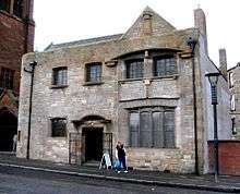
| North British Engine Works |
739 South Street |
22 August 1984 |
NS5341566914 |
55°52′23″N 4°20′40″W / 55.873024°N 4.344401°W / 55.873024; -4.344401 (North British Engine Works) |
|
32280 |
 Upload another image
|
| Former North British Diesel Engine Engine Works, Quayside Titan Crane |
739 South Street |
14 April 1989 |
NS5334166844 |
55°52′21″N 4°20′44″W / 55.872373°N 4.345545°W / 55.872373; -4.345545 (Former North British Diesel Engine Engine Works, Quayside Titan Crane) |
|
32281 |
Upload another image
|
| 48 Cleveden Drive, Stoneleigh, and Gatepiers |
|
15 December 1970 |
NS5597668019 |
55°53′01″N 4°18′15″W / 55.883717°N 4.304095°W / 55.883717; -4.304095 (48 Cleveden Drive, Stoneleigh, and Gatepiers) |
|
32306 |
|
| Forth and Clyde Canal Aqueduct |
Adjoining Skaethorn Road Bridge |
10 July 1989 |
NS5615268980 |
55°53′33″N 4°18′06″W / 55.892397°N 4.301795°W / 55.892397; -4.301795 (Forth and Clyde Canal Aqueduct) |
|
32316 |
|
| Gartnavel Royal Hospital |
1055 Great Western Road |
15 December 1970 |
NS5503068034 |
55°53′01″N 4°19′09″W / 55.883567°N 4.319213°W / 55.883567; -4.319213 (Gartnavel Royal Hospital) |
|
32318 |
 Upload another image
|
| St Mungos Academy Centenary Club |
998 Great Western Road |
15 December 1970 |
NS5593868004 |
55°53′01″N 4°18′17″W / 55.883571°N 4.304694°W / 55.883571; -4.304694 (St Mungos Academy Centenary Club) |
|
32334 |
|
| 11 Whittinghame Drive |
|
5 September 1979 |
NS5529068166 |
55°53′05″N 4°18′54″W / 55.884831°N 4.315131°W / 55.884831; -4.315131 (11 Whittinghame Drive) |
|
32342 |
|
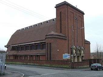
| Ruchill Church Hall |
17 Shakespeare Street |
15 December 1970 |
NS5725668308 |
55°53′12″N 4°17′02″W / 55.886692°N 4.283802°W / 55.886692; -4.283802 (Ruchill Church Hall) |
|
32356 |
 Upload another image
See more images
|
| Queen's Park Church and Hall |
20 Balvicar Drive, Balvicar Street, Camphill |
15 December 1970 |
NS5786562432 |
55°50′03″N 4°16′16″W / 55.834119°N 4.270993°W / 55.834119; -4.270993 (Queen's Park Church and Hall) |
|
32359 |
|
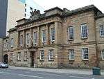
| Langside Hall |
1 Langside Avenue |
15 December 1970 |
NS5744562150 |
55°49′53″N 4°16′39″W / 55.831463°N 4.277545°W / 55.831463; -4.277545 (Langside Hall) |
|
32369 |
|
| 25, 25A Mansionhouse Road |
|
15 December 1970 |
NS5759161495 |
55°49′32″N 4°16′30″W / 55.825626°N 4.274872°W / 55.825626; -4.274872 (25, 25A Mansionhouse Road) |
|
32373 |
|
| 2, 2A-38 (Even Nos) Millbrae Crescent |
|
15 December 1970 |
NS5752161115 |
55°49′20″N 4°16′33″W / 55.822194°N 4.27579°W / 55.822194; -4.27579 (2, 2A-38 (Even Nos) Millbrae Crescent) |
|
32384 |
|
| 1-10 (Inclusive Nos) Moray Place Including 81 Nithsdale Road |
|
6 July 1966 |
NS5771962789 |
55°50′14″N 4°16′25″W / 55.837281°N 4.273509°W / 55.837281; -4.273509 (1-10 (Inclusive Nos) Moray Place Including 81 Nithsdale Road) |
|
32386 |
|
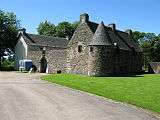
| Camphill House |
799 Pollokshaws Road |
15 December 1970 |
NS5759762225 |
55°49′56″N 4°16′31″W / 55.832181°N 4.27516°W / 55.832181; -4.27516 (Camphill House) |
|
32401 |
|
| 265-289 (Odd Nos) Allison Street 19, 21, 23 Garturk Street and 34 Daisy Street |
|
15 December 1970 |
NS5863262593 |
55°50′09″N 4°15′32″W / 55.83579°N 4.258841°W / 55.83579; -4.258841 (265-289 (Odd Nos) Allison Street 19, 21, 23 Garturk Street and 34 Daisy Street) |
|
32423 |
|
| Former Crosshill Queen's Park Church |
40 Queen's Drive |
15 December 1970 |
NS5846562186 |
55°49′56″N 4°15′41″W / 55.832087°N 4.261293°W / 55.832087; -4.261293 (Former Crosshill Queen's Park Church) |
|
32451 |
|
| Kelvinside Academy |
20 Bellshaugh Road |
6 July 1966 |
NS5655667906 |
55°52′58″N 4°17′41″W / 55.882875°N 4.294771°W / 55.882875; -4.294771 (Kelvinside Academy) |
|
32476 |
|
| 15 Cleveden Gardens |
|
15 December 1970 |
NS5625768120 |
55°53′05″N 4°17′59″W / 55.884707°N 4.29966°W / 55.884707; -4.29966 (15 Cleveden Gardens) |
|
32486 |
|
| 3-10 (Inclusive Nos) Crown Circus and 1, 1A and 2 Crown Terrace and 15 and 17 Crown Road North |
|
15 December 1970 |
NS5616067157 |
55°52′34″N 4°18′03″W / 55.876033°N 4.300698°W / 55.876033; -4.300698 (3-10 (Inclusive Nos) Crown Circus and 1, 1A and 2 Crown Terrace and 15 and 17 Crown Road North) |
|
32489 |
 Upload another image
|
| Kibble Palace |
Botanic Gardens, 730 Great Western Road |
15 December 1970 |
NS5693867446 |
55°52′44″N 4°17′18″W / 55.878859°N 4.288426°W / 55.878859; -4.288426 (Kibble Palace) |
|
32513 |
 Upload another image
See more images
|
| 1-11 (Inclusive Nos) Great Western Terrace, 2-34 (Even Nos) Great Western Terrace Lane, 1 and 1B Westbourne Gardens and 19 Westbourne Gardens |
Great Western Road |
15 December 1970 |
NS5621067704 |
55°52′51″N 4°18′01″W / 55.880959°N 4.30019°W / 55.880959; -4.30019 (1-11 (Inclusive Nos) Great Western Terrace, 2-34 (Even Nos) Great Western Terrace Lane, 1 and 1B Westbourne Gardens and 19 Westbourne Gardens) |
|
32517 |
|
| 1-17 (Inclusive Nos) Grosvenor Terrace |
Great Western Road |
6 July 1966 |
NS5670967376 |
55°52′41″N 4°17′31″W / 55.878163°N 4.292047°W / 55.878163; -4.292047 (1-17 (Inclusive Nos) Grosvenor Terrace) |
|
32520 |
|
| 21-39 (Odd Nos) Hyndland Road |
|
6 July 1966 |
NS5599367796 |
55°52′54″N 4°18′13″W / 55.88172°N 4.303705°W / 55.88172; -4.303705 (21-39 (Odd Nos) Hyndland Road) |
|
32530 |
|
| Hyndland Parish Church, Church of Scotland |
79 Hyndland Road |
15 December 1970 |
NS5588167507 |
55°52′45″N 4°18′19″W / 55.879092°N 4.30534°W / 55.879092; -4.30534 (Hyndland Parish Church, Church of Scotland) |
|
32532 |
|
| 3 Kirklee Road and 1 Redlands Road |
|
15 December 1970 |
NS5639767727 |
55°52′52″N 4°17′50″W / 55.881221°N 4.297216°W / 55.881221; -4.297216 (3 Kirklee Road and 1 Redlands Road) |
|
32550 |
|
| 7-23 (Odd Nos) Kirklee Road and 2 Redlands Road |
|
15 December 1970 |
NS5644067786 |
55°52′54″N 4°17′48″W / 55.881763°N 4.29656°W / 55.881763; -4.29656 (7-23 (Odd Nos) Kirklee Road and 2 Redlands Road) |
|
32551 |
|
| 1-14 (Inclusive Nos) Kirklee Terrace, and 1-14 Kirklee Terrace Lane (Inclusive Numbers) |
Great Western Road |
6 July 1966 |
NS5657567630 |
55°52′49″N 4°17′40″W / 55.880403°N 4.294321°W / 55.880403; -4.294321 (1-14 (Inclusive Nos) Kirklee Terrace, and 1-14 Kirklee Terrace Lane (Inclusive Numbers)) |
|
32553 |
|
| 9 Lowther Terrace |
Great Western Road |
15 December 1970 |
NS5630067744 |
55°52′53″N 4°17′56″W / 55.881345°N 4.298774°W / 55.881345; -4.298774 (9 Lowther Terrace) |
|
32563 |
|
| 10 Lowther Terrace |
Great Western Road |
15 December 1970 |
NS5628867750 |
55°52′53″N 4°17′56″W / 55.881395°N 4.298969°W / 55.881395; -4.298969 (10 Lowther Terrace) |
|
32564 |
|
| Notre Dame High School |
160 Observatory Road |
28 July 1987 |
NS5626667407 |
55°52′42″N 4°17′57″W / 55.878309°N 4.299138°W / 55.878309; -4.299138 (Notre Dame High School) |
Damaged by fire, 2010 |
32571 |
|
| 1 Princes Terrace |
Prince Albert Road |
15 December 1970 |
NS5616267256 |
55°52′37″N 4°18′03″W / 55.876922°N 4.300719°W / 55.876922; -4.300719 (1 Princes Terrace) |
|
32576 |
 Upload another image
|
| Kelvinside Hillhead Parish Church, Glasgow |
23 Saltoun Street |
15 December 1970 |
NS5662967303 |
55°52′39″N 4°17′36″W / 55.877483°N 4.293286°W / 55.877483; -4.293286 (Kelvinside Hillhead Parish Church, Glasgow) |
Church of Scotland. Formerly Belmont and Hillhead Parish Church |
32584 |
 Upload another image
See more images
|
| Belhaven-Westbourne Church and Hall, Church of Scotland |
52 Westbourne Gardens |
15 December 1970 |
NS5602167768 |
55°52′53″N 4°18′12″W / 55.881477°N 4.303243°W / 55.881477; -4.303243 (Belhaven-Westbourne Church and Hall, Church of Scotland) |
|
32605 |
|
| 145-195 (Odd Nos) Albion Street |
|
3 September 1974 |
NS5965565265 |
55°51′36″N 4°14′38″W / 55.860078°N 4.243903°W / 55.860078; -4.243903 (145-195 (Odd Nos) Albion Street) |
|
32607 |
|
| Buck's Head Buildings |
63 Argyle Street |
15 December 1970 |
NS5918565002 |
55°51′27″N 4°15′05″W / 55.857579°N 4.251269°W / 55.857579; -4.251269 (Buck's Head Buildings) |
|
32608 |
|
| Argyle Street, Argyll Arcade (Through 98-102 Argyle Street) 3-66 (Inclusive Nos, Leading to Buchanan Street) |
Argyle Street |
15 December 1970 |
NS5906065089 |
55°51′30″N 4°15′12″W / 55.858324°N 4.25331°W / 55.858324; -4.25331 (Argyle Street, Argyll Arcade (Through 98-102 Argyle Street) 3-66 (Inclusive Nos, Leading to Buchanan Street)) |
|
32613 |
|
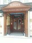
| David Sloan's Arcade Cafe |
62 Argyll Arcade/108 Argyle Street, Morrison Court |
15 December 1970 |
NS5903665113 |
55°51′31″N 4°15′13″W / 55.858532°N 4.253705°W / 55.858532; -4.253705 (David Sloan's Arcade Cafe) |
|
32614 |
 Upload another image
|
| Martyrs' Public School |
|
15 December 1970 |
NS6008165839 |
55°51′55″N 4°14′15″W / 55.865355°N 4.237399°W / 55.865355; -4.237399 (Martyrs' Public School) |
17 Parson Street |
32619 |
|
| 60-62 (Even Nos) Buchanan Street |
Buchanan Street |
15 December 1970 |
NS5901965226 |
55°51′34″N 4°15′15″W / 55.859542°N 4.254035°W / 55.859542; -4.254035 (60-62 (Even Nos) Buchanan Street) |
|
32635 |
|
| 92-100 (Even Nos) Buchanan Street, known as 98 Buchanan Street |
Buchanan Street |
15 December 1970 |
NS5903365310 |
55°51′37″N 4°15′14″W / 55.8603°N 4.253856°W / 55.8603; -4.253856 (92-100 (Even Nos) Buchanan Street, known as 98 Buchanan Street) |
|
32639 |
|
| Brittania Buildings |
164A-168 (Even Nos) Buchanan Street with 10 Dundas Lane |
15 December 1970 |
NS5909765542 |
55°51′45″N 4°15′11″W / 55.862402°N 4.252954°W / 55.862402; -4.252954 (Brittania Buildings) |
|
32643 |
|
| Glasgow City Halls |
Candleriggs, Merchant City |
15 December 1970 |
NS5957165145 |
55°51′32″N 4°14′43″W / 55.858976°N 4.245182°W / 55.858976; -4.245182 (Glasgow City Halls) |
|
32647 |
 Upload another image
See more images
|
| Provand's Lordship |
3 Castle Street |
6 July 1966 |
NS6009665506 |
55°51′45″N 4°14′13″W / 55.86237°N 4.236987°W / 55.86237; -4.236987 (Provand's Lordship) |
|
32648 |
 Upload another image
See more images
|
| Bridge of Sighs and Superintendent's House |
Cathedral Square |
15 December 1970 |
NS6018265506 |
55°51′45″N 4°14′08″W / 55.862395°N 4.235614°W / 55.862395; -4.235614 (Bridge of Sighs and Superintendent's House) |
Includes gates and gatepiers |
32651 |
|
| Glasgow Evangelical Church; (Former Barony North Church), and Church House |
20 Cathedral Square, 14 Cathedral Square |
15 December 1970 |
NS6021265399 |
55°51′41″N 4°14′06″W / 55.861443°N 4.23508°W / 55.861443; -4.23508 (Glasgow Evangelical Church; (Former Barony North Church), and Church House) |
|
32652 |
 Upload another image
See more images
|
| Glasgow Cathedral and Cathedral Graveyard |
70 Cathedral Square |
15 December 1970 |
NS6025565657 |
55°51′50″N 4°14′04″W / 55.863771°N 4.234527°W / 55.863771; -4.234527 (Glasgow Cathedral and Cathedral Graveyard) |
|
32654 |
 Upload another image
See more images
|
| Statue of William III |
Cathedral Square |
6 July 1966 |
NS6013565441 |
55°51′42″N 4°14′11″W / 55.861797°N 4.236331°W / 55.861797; -4.236331 (Statue of William III) |
|
32660 |
_statue_-_geograph.org.uk_-_940023.jpg) Upload another image
|
| Former Lady and St Francis Secondary School |
72 Charlotte Street |
4 September 1989 |
NS5979364539 |
55°51′13″N 4°14′29″W / 55.8536°N 4.241324°W / 55.8536; -4.241324 (Former Lady and St Francis Secondary School) |
|
32662 |
|
| 52 Charlotte Street |
|
15 December 1970 |
NS5983264628 |
55°51′16″N 4°14′27″W / 55.85441°N 4.240748°W / 55.85441; -4.240748 (52 Charlotte Street) |
|
32663 |
|
| Old Fish Market known as the Briggait |
72 Clyde Street and 135 Bridgegate |
15 October 1970 |
NS5928264640 |
55°51′16″N 4°14′58″W / 55.854358°N 4.249533°W / 55.854358; -4.249533 (Old Fish Market known as the Briggait) |
|
32664 |
 Upload another image
See more images
|
| Merchants Steeple, Now Enclosed Within The Briggait |
72 Clyde Street, Bridgegate |
6 July 1966 |
NS5930564671 |
55°51′17″N 4°14′57″W / 55.854643°N 4.249182°W / 55.854643; -4.249182 (Merchants Steeple, Now Enclosed Within The Briggait) |
|
32665 |
 Upload another image
|
| St Andrew's Roman Catholic Cathedral |
168 Clyde Street and Fox Lane |
15 December 1970 |
NS5908064792 |
55°51′20″N 4°15′10″W / 55.855663°N 4.252836°W / 55.855663; -4.252836 (St Andrew's Roman Catholic Cathedral) |
|
32666 |
 Upload another image
See more images
|
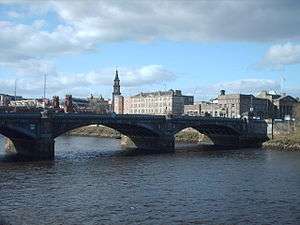
| Albert Bridge |
Clyde Street |
22 March 1977 |
NS5941264443 |
55°51′09″N 4°14′50″W / 55.852627°N 4.247356°W / 55.852627; -4.247356 (Albert Bridge) |
|
32667 |
 Upload another image
See more images
|
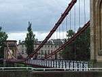
| South Portland Street Suspension Bridge |
Clyde Street and South Portland Street |
6 July 1966 |
NS5890764722 |
55°51′18″N 4°15′20″W / 55.854984°N 4.255561°W / 55.854984; -4.255561 (South Portland Street Suspension Bridge) |
|
32668 |
 Upload another image
See more images
|
| Victoria Bridge |
Clyde Street |
15 December 1970 |
NS5917364578 |
55°51′14″N 4°15′04″W / 55.853769°N 4.25124°W / 55.853769; -4.25124 (Victoria Bridge) |
|
32669 |
 Upload another image
See more images
|
| Formerly the John Street Church |
29 Cochrane Street and 18 John Street |
15 December 1970 |
NS5943665275 |
55°51′36″N 4°14′51″W / 55.860104°N 4.247404°W / 55.860104; -4.247404 (Formerly the John Street Church) |
|
32672 |
|
| Extension to the City Chambers |
20-40 (Even Nos) Cochrane Street, 20 John Street and 233-235 (Odd Nos) George Street |
15 December 1970 |
NS5943465380 |
55°51′40″N 4°14′51″W / 55.861046°N 4.24749°W / 55.861046; -4.24749 (Extension to the City Chambers) |
|
32675 |
|
| Former General Post Office |
George Square |
15 December 1970 |
NS5928265311 |
55°51′37″N 4°15′00″W / 55.860382°N 4.249881°W / 55.860382; -4.249881 (Former General Post Office) |
|
32685 |
 Upload another image
|
| 24 George Square and 12-16 (Even Nos) Anchor Lane |
George Square |
15 December 1970 |
NS5916465420 |
55°51′41″N 4°15′07″W / 55.861326°N 4.251821°W / 55.861326; -4.251821 (24 George Square and 12-16 (Even Nos) Anchor Lane) |
|
32688 |
|
| The Merchants' House |
30 George Square and 7 West George Street |
15 December 1970 |
NS5916965440 |
55°51′41″N 4°15′06″W / 55.861507°N 4.251752°W / 55.861507; -4.251752 (The Merchants' House) |
|
32689 |
 Upload another image
|
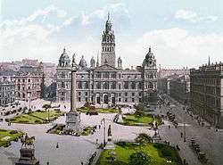
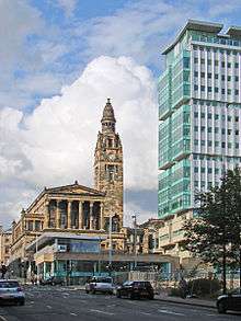
| Glasgow City Chambers |
80 George Square |
15 December 1970 |
NS5936065375 |
55°51′40″N 4°14′55″W / 55.860979°N 4.248669°W / 55.860979; -4.248669 (Glasgow City Chambers) |
|
32691 |
 Upload another image
See more images
|
| Walter Scott Memorial Column |
George Square |
6 July 1966 |
NS5926665396 |
55°51′40″N 4°15′01″W / 55.86114°N 4.250181°W / 55.86114; -4.250181 (Walter Scott Memorial Column) |
|
32696 |
 Upload another image
See more images
|
| James Watt Statue |
George Square |
6 July 1966 |
NS5920065384 |
55°51′40″N 4°15′04″W / 55.861013°N 4.251228°W / 55.861013; -4.251228 (James Watt Statue) |
|
32697 |
 Upload another image
See more images
|
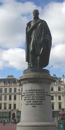
| Sir John Moore Statue |
George Square |
6 July 1966 |
NS5931565357 |
55°51′39″N 4°14′58″W / 55.860804°N 4.249378°W / 55.860804; -4.249378 (Sir John Moore Statue) |
|
32698 |
 Upload another image
See more images
|
| Prince Albert Statue |
George Square |
15 December 1970 |
NS5920065384 |
55°51′40″N 4°15′04″W / 55.861013°N 4.251228°W / 55.861013; -4.251228 (Prince Albert Statue) |
|
32701 |
.jpg) Upload another image
|
| Queen Victoria Statue |
George Square |
15 December 1970 |
NS5921465439 |
55°51′41″N 4°15′04″W / 55.861511°N 4.251033°W / 55.861511; -4.251033 (Queen Victoria Statue) |
|
32702 |
 Upload another image
See more images
|
| 266 George Street |
|
9 March 1989 |
NS5940565443 |
55°51′42″N 4°14′53″W / 55.861603°N 4.247986°W / 55.861603; -4.247986 (266 George Street) |
|
32709 |
|
| The Trades Hall of Glasgow |
85 Glassford Street |
6 July 1966 |
NS5932965183 |
55°51′33″N 4°14′57″W / 55.859246°N 4.249064°W / 55.859246; -4.249064 (The Trades Hall of Glasgow) |
|
32713 |
|
| Tolbooth Steeple |
Glasgow Cross |
6 July 1966 |
NS5965964900 |
55°51′24″N 4°14′37″W / 55.856802°N 4.24365°W / 55.856802; -4.24365 (Tolbooth Steeple) |
|
32717 |
 Upload another image
See more images
|
| 177 Ingram Street with 99 Glassford Street |
|
15 December 1970 |
NS5933365224 |
55°51′35″N 4°14′56″W / 55.859616°N 4.249022°W / 55.859616; -4.249022 (177 Ingram Street with 99 Glassford Street) |
|
32734 |
|
| Lanarkshire House, Corinthian (Former Sheriff Court and Justice of Peace Court) |
191 Ingram Street |
15 December 1970 |
NS5928965217 |
55°51′34″N 4°14′59″W / 55.85954°N 4.249721°W / 55.85954; -4.249721 (Lanarkshire House, Corinthian (Former Sheriff Court and Justice of Peace Court)) |
|
32735 |
 Upload another image
|
| Ramshorn Theatre |
98 Ingram Street |
15 December 1970 |
NS5958565228 |
55°51′35″N 4°14′42″W / 55.859725°N 4.245001°W / 55.859725; -4.245001 (Ramshorn Theatre) |
Formerly St Paul's and St David's Church, Church of Scotland |
32740 |
 Upload another image
|
| Hutchesons' Hall |
158 Ingram Street, and 2 John Street |
6 November 1966 |
NS5942265249 |
55°51′36″N 4°14′51″W / 55.859866°N 4.247614°W / 55.859866; -4.247614 (Hutchesons' Hall) |
|
32744 |
 Upload another image
|
| 16 Mcphater Street, and Return Elevation to Dunblane Street (Ozalid's) |
|
15 December 1970 |
NS5897666080 |
55°52′02″N 4°15′19″W / 55.867196°N 4.255166°W / 55.867196; -4.255166 (16 Mcphater Street, and Return Elevation to Dunblane Street (Ozalid's)) |
|
32754 |
|
| 61-63 (Odd Nos) Miller Street |
|
15 December 1970 |
NS5919065177 |
55°51′33″N 4°15′05″W / 55.859152°N 4.25128°W / 55.859152; -4.25128 (61-63 (Odd Nos) Miller Street) |
|
32758 |
|
| Arthur's Warehouse |
77-81 (Odd Nos) Miller Street |
6 November 1966 |
NS5920065207 |
55°51′34″N 4°15′04″W / 55.859424°N 4.251136°W / 55.859424; -4.251136 (Arthur's Warehouse) |
|
32759 |
|
| 42 Miller Street |
|
15 December 1970 |
NS5921265125 |
55°51′31″N 4°15′03″W / 55.858692°N 4.250902°W / 55.858692; -4.250902 (42 Miller Street) |
|
32760 |
|
| Formerly Stirling's Library |
48-54 (Even Nos) Miller Street |
15 December 1970 |
NS5921565142 |
55°51′32″N 4°15′03″W / 55.858845°N 4.250863°W / 55.858845; -4.250863 (Formerly Stirling's Library) |
|
32761 |
|
| Tron Steeple |
71 Trongate |
6 July 1966 |
NS5954264916 |
55°51′25″N 4°14′44″W / 55.856911°N 4.245526°W / 55.856911; -4.245526 (Tron Steeple) |
|
32769 |
 Upload another image
See more images
|
| Britannia Music Hall |
109-121 (Odd Nos) Trongate and 9 New Wynd |
22 March 1977 |
NS5945264917 |
55°51′25″N 4°14′49″W / 55.856894°N 4.246963°W / 55.856894; -4.246963 (Britannia Music Hall) |
|
32774 |
 Upload another image
|
| 60-90 (Even Nos) Trongate and 19-29 (Odd Nos) Albion Street |
|
15 December 1970 |
NS5952964955 |
55°51′26″N 4°14′45″W / 55.857258°N 4.245754°W / 55.857258; -4.245754 (60-90 (Even Nos) Trongate and 19-29 (Odd Nos) Albion Street) |
|
32782 |
|
| 190 Trongate and 2-4 (Even Nos) Glassford Street |
|
15 December 1970 |
NS5932664999 |
55°51′27″N 4°14′56″W / 55.857594°N 4.249017°W / 55.857594; -4.249017 (190 Trongate and 2-4 (Even Nos) Glassford Street) |
|
32789 |
|
| St Andrew's-by-the-Green |
33 Turnbull Street |
6 July 1966 |
NS5961964601 |
55°51′15″N 4°14′39″W / 55.854106°N 4.244134°W / 55.854106; -4.244134 (St Andrew's-by-the-Green) |
|
32790 |
 Upload another image
|
| 37-47 (Odd Nos) Virginia Street |
|
15 December 1970 |
NS5925965135 |
55°51′32″N 4°15′01″W / 55.858795°N 4.250157°W / 55.858795; -4.250157 (37-47 (Odd Nos) Virginia Street) |
|
32795 |
|
| 49-53 (Odd Nos) Virginia Street |
|
15 December 1970 |
NS5926165150 |
55°51′32″N 4°15′00″W / 55.85893°N 4.250133°W / 55.85893; -4.250133 (49-53 (Odd Nos) Virginia Street) |
|
32796 |
|
| 42 Virginia Street |
|
15 December 1970 |
NS5928465101 |
55°51′31″N 4°14′59″W / 55.858497°N 4.24974°W / 55.858497; -4.24974 (42 Virginia Street) |
|
32798 |
|
| Tron Theatre |
38 Parnie Street |
15 December 1970 |
NS5952664880 |
55°51′24″N 4°14′45″W / 55.856584°N 4.245763°W / 55.856584; -4.245763 (Tron Theatre) |
Former Tron Kirk |
32812 |
 Upload another image
|
| Gallery of Modern Art |
111 Queen Street and 46-58 (Even Nos) Royal Exchange Square |
6 July 1966 |
NS5912565288 |
55°51′36″N 4°15′09″W / 55.860129°N 4.252375°W / 55.860129; -4.252375 (Gallery of Modern Art) |
Former Stirling's Library, Former Cunninghame Mansion and Former Royal Exchange |
32818 |
 Upload another image
See more images
|
| St George's Buildings |
151-157 (Odd Nos) Queen Street |
6 July 1966 |
NS5914265344 |
55°51′38″N 4°15′08″W / 55.860637°N 4.252133°W / 55.860637; -4.252133 (St George's Buildings) |
|
32819 |
|
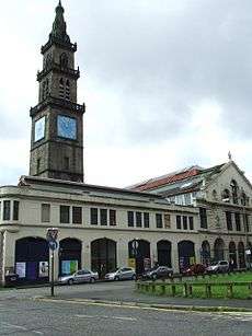
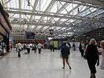
| Queen Street station |
Cathedral Street |
15 December 1970 |
NS5920765545 |
55°51′45″N 4°15′04″W / 55.862461°N 4.2512°W / 55.862461; -4.2512 (Queen Street station) |
|
32822 |
.jpg) Upload another image
See more images
|
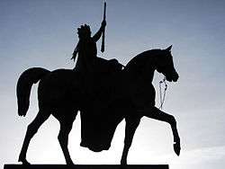
| Duke of Wellington Statue |
Queen Street |
15 December 1970 |
NS5914665283 |
55°51′36″N 4°15′07″W / 55.860091°N 4.252038°W / 55.860091; -4.252038 (Duke of Wellington Statue) |
|
32823 |
 Upload another image
See more images
|
| Barony Hall, University of Strathclyde |
Cathedral Square |
6 July 1966 |
NS6008665451 |
55°51′43″N 4°14′14″W / 55.861873°N 4.237119°W / 55.861873; -4.237119 (Barony Hall, University of Strathclyde) |
Former Barony Church and Church Hall. Listing includes War Memorial, retaining wall, railings and gatepiers |
32824 |
 Upload another image
See more images
|
| 1-29 (Odd Nos) and 2-40 (Even Nos) Royal Exchange Square with 145-147 (Odd Nos) Queen Street and Archways |
|
15 December 1970 |
NS5913965323 |
55°51′38″N 4°15′08″W / 55.860448°N 4.25217°W / 55.860448; -4.25217 (1-29 (Odd Nos) and 2-40 (Even Nos) Royal Exchange Square with 145-147 (Odd Nos) Queen Street and Archways) |
|
32826 |
|
| Royal Bank of Scotland |
Royal Exchange Square |
6 July 1966 |
NS5905365305 |
55°51′37″N 4°15′13″W / 55.860261°N 4.253534°W / 55.860261; -4.253534 (Royal Bank of Scotland) |
|
32827 |
 Upload another image
|
| Blochairn Parish Church (Church of Scotland) |
178 Royston Hill, Townhead |
3 September 1974 |
NS6072166112 |
55°52′05″N 4°13′38″W / 55.867991°N 4.227321°W / 55.867991; -4.227321 (Blochairn Parish Church (Church of Scotland)) |
|
32828 |
 Upload another image
See more images
|
| St Andrew's in the Square |
St Andrews Square |
6 July 1966 |
NS5970264677 |
55°51′17″N 4°14′34″W / 55.854812°N 4.242848°W / 55.854812; -4.242848 (St Andrew's in the Square) |
|
32830 |
 Upload another image
See more images
|
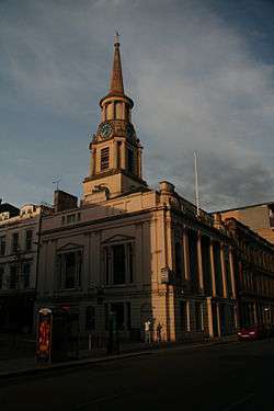
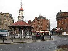
| St Enoch Square Travel Centre |
St Enoch Square |
15 December 1970 |
NS5893765003 |
55°51′27″N 4°15′19″W / 55.857516°N 4.255228°W / 55.857516; -4.255228 (St Enoch Square Travel Centre) |
Formerly St Enoch Underground Station |
32833 |
 Upload another image
See more images
|
| Scottish Provident Institution |
17-29 (Odd Nos) St Vincent Place |
15 December 1970 |
NS5910365359 |
55°51′39″N 4°15′10″W / 55.86076°N 4.252764°W / 55.86076; -4.252764 (Scottish Provident Institution) |
|
32836 |
|
| 2 St Vincent Place and 2 and 4 Anchor Lane |
|
6 July 1966 |
NS5915865407 |
55°51′40″N 4°15′07″W / 55.861208°N 4.251911°W / 55.861208; -4.251911 (2 St Vincent Place and 2 and 4 Anchor Lane) |
|
32838 |
|
| Anchor Building |
12-16 (Even Nos) St Vincent Place |
15 December 1970 |
NS5913365415 |
55°51′41″N 4°15′08″W / 55.861272°N 4.252314°W / 55.861272; -4.252314 (Anchor Building) |
|
32839 |
|
| Citizen Building |
24 St Vincent Place |
15 December 1970 |
NS5911065420 |
55°51′41″N 4°15′10″W / 55.86131°N 4.252684°W / 55.86131; -4.252684 (Citizen Building) |
|
32840 |
 Upload another image
|
| 30 St Vincent Place |
|
15 December 1970 |
NS5908065432 |
55°51′41″N 4°15′11″W / 55.861409°N 4.253169°W / 55.861409; -4.253169 (30 St Vincent Place) |
|
32841 |
|
| Justiciary Courts |
212 Saltmarket |
15 December 1970 |
NS5943664559 |
55°51′13″N 4°14′49″W / 55.853675°N 4.247033°W / 55.853675; -4.247033 (Justiciary Courts) |
|
32844 |
|
| 1-16 (Inclusive Nos) Buckingham Terrace, 2, 4 Buckingham Street, 1, 3 Ruskin Place |
Great Western Road |
15 December 1970 |
NS5702967267 |
55°52′38″N 4°17′13″W / 55.877279°N 4.286879°W / 55.877279; -4.286879 (1-16 (Inclusive Nos) Buckingham Terrace, 2, 4 Buckingham Street, 1, 3 Ruskin Place) |
|
32850 |
|
| Lilybank House |
University of Glasgow, Gilmorehill Campus |
15 December 1970 |
NS5679666912 |
55°52′26″N 4°17′25″W / 55.874023°N 4.290412°W / 55.874023; -4.290412 (Lilybank House) |
|
32853 |
 Upload another image
|
| 35-51 (Odd Nos) Hamilton Drive, (1-9 Inclusive Nos) Northpark Terrace |
Kelvinside |
15 December 1970 |
NS5709767277 |
55°52′39″N 4°17′09″W / 55.877389°N 4.285798°W / 55.877389; -4.285798 (35-51 (Odd Nos) Hamilton Drive, (1-9 Inclusive Nos) Northpark Terrace) |
|
32874 |
|
| Cottier Theatre Complex |
93-95 (Odd Nos) Hyndland Street |
15 December 1970 |
NS5607866959 |
55°52′27″N 4°18′07″W / 55.874231°N 4.301902°W / 55.874231; -4.301902 (Cottier Theatre Complex) |
Former Dowanhill Church and Halls |
32879 |
|
| Woodbank |
56 Partickhill Road |
15 December 1970 |
NS5566267007 |
55°52′28″N 4°18′31″W / 55.874537°N 4.308571°W / 55.874537; -4.308571 (Woodbank) |
|
32895 |
|
| 1-9 (Inclusive Nos) Ruskin Terrace, 1, 1A, 3 Hamilton Park Avenue |
|
15 December 1970 |
NS5723167155 |
55°52′35″N 4°17′01″W / 55.876334°N 4.283594°W / 55.876334; -4.283594 (1-9 (Inclusive Nos) Ruskin Terrace, 1, 1A, 3 Hamilton Park Avenue) |
|
32903 |
|
| Wellington Church |
76 University Avenue |
6 July 1966 |
NS5700466748 |
55°52′21″N 4°17′13″W / 55.872612°N 4.287004°W / 55.872612; -4.287004 (Wellington Church) |
|
32912 |
 Upload another image
See more images
|
| Gilbert Scott Building and Memorial Chapel (with the Lion and Unicorn Staircase) |
University of Glasgow, Gilmorehill Campus |
15 December 1970 |
NS5687866664 |
55°52′19″N 4°17′20″W / 55.871821°N 4.288971°W / 55.871821; -4.288971 (Gilbert Scott Building and Memorial Chapel (with the Lion and Unicorn Staircase)) |
|
32913 |
|
| Joseph Black Building |
University of Glasgow, Gilmorehill Campus |
15 January 1985 |
NS5661466700 |
55°52′19″N 4°17′36″W / 55.872065°N 4.293206°W / 55.872065; -4.293206 (Joseph Black Building) |
|
32918 |
|
| Pearce Lodge |
University of Glasgow, Gilmorehill Campus |
15 December 1970 |
NS5707066668 |
55°52′19″N 4°17′09″W / 55.871914°N 4.285908°W / 55.871914; -4.285908 (Pearce Lodge) |
|
32925 |
|
| McMillan Reading Room |
University of Glasgow, Gilmorehill Campus |
15 January 1985 |
NS5693966755 |
55°52′22″N 4°17′17″W / 55.872656°N 4.288045°W / 55.872656; -4.288045 (McMillan Reading Room) |
|
32927 |
|
| Graham Kerr Building |
University of Glasgow, Gilmorehill Campus |
15 December 1970 |
NS5662566631 |
55°52′17″N 4°17′35″W / 55.871449°N 4.292994°W / 55.871449; -4.292994 (Graham Kerr Building) |
|
32928 |
|
| 2-10 (Inclusive) University Gardens |
University of Glasgow, Gilmorehill Campus |
15 December 1970 |
NS5680766794 |
55°52′23″N 4°17′25″W / 55.872967°N 4.290174°W / 55.872967; -4.290174 (2-10 (Inclusive) University Gardens) |
|
32931 |
|
| Salmon House (12 University Gardens) |
University of Glasgow, Gilmorehill Campus |
15 December 1970 |
NS5677966820 |
55°52′23″N 4°17′26″W / 55.873192°N 4.290635°W / 55.873192; -4.290635 (Salmon House (12 University Gardens)) |
|
32932 |
|
| 14 University Gardens |
University of Glasgow, Gilmorehill Campus |
15 December 1970 |
NS5677366830 |
55°52′24″N 4°17′27″W / 55.87328°N 4.290736°W / 55.87328; -4.290736 (14 University Gardens) |
|
32933 |
|
| The Salon |
17 Vinicombe Street |
22 March 1977 |
NS5679167237 |
55°52′37″N 4°17′26″W / 55.876939°N 4.290664°W / 55.876939; -4.290664 (The Salon) |
|
32934 |
 Upload another image
|
| Former Botanic Gardens Garage |
24 Vinicombe Street |
6 February 1989 |
NS5683867267 |
55°52′38″N 4°17′24″W / 55.877222°N 4.289929°W / 55.877222; -4.289929 (Former Botanic Gardens Garage) |
|
32935 |
 Upload another image
|
| Savings Bank of Glasgow |
752-756 (Even Nos) Argyle Street and 3, 5, 7 Shaftesbury Street |
15 December 1970 |
NS5776665519 |
55°51′42″N 4°16′27″W / 55.861804°N 4.274191°W / 55.861804; -4.274191 (Savings Bank of Glasgow) |
|
32953 |
|
| 181-199 (Odd Nos) Bath Street and Blythswood Street |
|
15 December 1970 |
NS5847165788 |
55°51′52″N 4°15′47″W / 55.864427°N 4.263077°W / 55.864427; -4.263077 (181-199 (Odd Nos) Bath Street and Blythswood Street) |
Includes the Glasgow Art Club |
32960 |
|
| King's Theatre |
335 Bath Street and Elmbank Street |
15 December 1970 |
NS5811965874 |
55°51′54″N 4°16′07″W / 55.865095°N 4.268741°W / 55.865095; -4.268741 (King's Theatre) |
|
32963 |
|
| Mercantile Chambers |
39-69 (Odd Nos) Bothwell Street |
15 December 1970 |
NS5858165401 |
55°51′40″N 4°15′40″W / 55.860985°N 4.261118°W / 55.860985; -4.261118 (Mercantile Chambers) |
|
32980 |
|
| 2-28 (Even Nos) Bothwell Street, 123 Hope Street |
|
24 July 1973 |
NS5871365426 |
55°51′40″N 4°15′32″W / 55.861248°N 4.259024°W / 55.861248; -4.259024 (2-28 (Even Nos) Bothwell Street, 123 Hope Street) |
|
32983 |
|
| 21-31 (Odd Nos) (Known As 21) Buchanan Street and 8-28 (Even Nos) Mitchell Street |
|
15 December 1970 |
NS5891865134 |
55°51′31″N 4°15′20″W / 55.858686°N 4.2556°W / 55.858686; -4.2556 (21-31 (Odd Nos) (Known As 21) Buchanan Street and 8-28 (Even Nos) Mitchell Street) |
|
32991 |
|
| Former Wylie and Lochead's |
45 Buchanan Street and 34-50 (Even Nos) Mitchell Street |
23 March 1977 |
NS5893165178 |
55°51′33″N 4°15′19″W / 55.859085°N 4.255415°W / 55.859085; -4.255415 (Former Wylie and Lochead's) |
|
32992 |
|
| 91 Buchanan Street |
|
15 December 1970 |
NS5897765269 |
55°51′36″N 4°15′17″W / 55.859916°N 4.254728°W / 55.859916; -4.254728 (91 Buchanan Street) |
|
32998 |
|
| 113-115 (Odd Nos) Buchanan Street and 4 Gordon Street |
|
15 December 1970 |
NS5899965335 |
55°51′38″N 4°15′16″W / 55.860515°N 4.254411°W / 55.860515; -4.254411 (113-115 (Odd Nos) Buchanan Street and 4 Gordon Street) |
|
33000 |
_BUCHANAN_STREET_AND_4_GORDON_STREET.jpg) Upload another image
|
| Former Western Club |
147 Buchanan Street and St Vincent Street |
15 December 1970 |
NS5901865433 |
55°51′41″N 4°15′15″W / 55.8614°N 4.254159°W / 55.8614; -4.254159 (Former Western Club) |
|
33002 |
|
| St George's Tron Parish Church |
163 Buchanan Street |
6 July 1966 |
NS5903265500 |
55°51′43″N 4°15′14″W / 55.862006°N 4.25397°W / 55.862006; -4.25397 (St George's Tron Parish Church) |
Church of Scotland |
33003 |
 Upload another image
See more images
|
| Former Athenaeum Theatre |
179 Buchanan Street |
6 July 1966 |
NS5903765562 |
55°51′45″N 4°15′14″W / 55.862564°N 4.253923°W / 55.862564; -4.253923 (Former Athenaeum Theatre) |
|
33004 |
|
| No 4 Clairmont Gardens |
|
15 December 1970 |
NS5759266077 |
55°52′00″N 4°16′38″W / 55.866762°N 4.277262°W / 55.866762; -4.277262 (No 4 Clairmont Gardens) |
|
33008 |
|
| Former Custom House |
298-306 (Even Nos) Clyde Street |
15 December 1970 |
NS5884764881 |
55°51′23″N 4°15′24″W / 55.856394°N 4.256601°W / 55.856394; -4.256601 (Former Custom House) |
Now Office of Procurator Fiscal |
33012 |
 Upload another image
|
| 49 Derby Street, 22, 30 Bentinck Street |
|
6 July 1966 |
NS5711766068 |
55°52′00″N 4°17′05″W / 55.866541°N 4.284841°W / 55.866541; -4.284841 (49 Derby Street, 22, 30 Bentinck Street) |
|
33015 |
|
| 17-21 (Odd Nos) Drury Street |
Including the "Horseshoe" pub |
21 July 1988 |
NS5887365371 |
55°51′39″N 4°15′23″W / 55.860801°N 4.256441°W / 55.860801; -4.256441 (17-21 (Odd Nos) Drury Street) |
|
33016 |
|
| 120, Elmbank Street with 71-83 (Odd Nos) Holland Street and Lodges, 59, 61 Holland Street |
|
15 December 1970 |
NS5817865784 |
55°51′51″N 4°16′04″W / 55.864305°N 4.267752°W / 55.864305; -4.267752 (120, Elmbank Street with 71-83 (Odd Nos) Holland Street and Lodges, 59, 61 Holland Street) |
|
33022 |
|
| Central Station & Hotel |
Gordon Street |
15 December 1970 |
NS5872765252 |
55°51′35″N 4°15′31″W / 55.85969°N 4.25871°W / 55.85969; -4.25871 (Central Station & Hotel) |
|
33029 |
 Upload another image
See more images
|
| 6 Gordon Street, Part of Former Commercial Bank |
|
6 July 1966 |
NS5895965350 |
55°51′38″N 4°15′18″W / 55.860638°N 4.255058°W / 55.860638; -4.255058 (6 Gordon Street, Part of Former Commercial Bank) |
|
33030 |
|
| 20-40 (Even Nos) Gordon Street and 1, 3 West Nile Street |
|
15 December 1970 |
NS5889765358 |
55°51′38″N 4°15′22″W / 55.860691°N 4.256052°W / 55.860691; -4.256052 (20-40 (Even Nos) Gordon Street and 1, 3 West Nile Street) |
|
33031 |
|
| 72-80 (Even Nos) Gordon Street, Grosvenor Building |
|
15 December 1970 |
NS5879365372 |
55°51′39″N 4°15′28″W / 55.860786°N 4.257719°W / 55.860786; -4.257719 (72-80 (Even Nos) Gordon Street, Grosvenor Building) |
|
33034 |
|
| Mitchell Theatre |
Granville Street, Berkeley Street and Kent Road |
6 July 1966 |
NS5782365843 |
55°51′53″N 4°16′24″W / 55.86473°N 4.273451°W / 55.86473; -4.273451 (Mitchell Theatre) |
Formerly St Andrew's Halls |
33036 |
|
| Breadalbane Terrace |
97-113B (Odd Nos) Hill Street |
15 December 1970 |
NS5832466078 |
55°52′01″N 4°15′56″W / 55.866987°N 4.265575°W / 55.866987; -4.265575 (Breadalbane Terrace) |
|
33038 |
|
| Hill Street Synagogue |
129 Hill Street and 29 Garnet Street |
27 November 1979 |
NS5819166096 |
55°52′02″N 4°16′04″W / 55.86711°N 4.267708°W / 55.86711; -4.267708 (Hill Street Synagogue) |
|
33040 |
 Upload another image
See more images
|
| Peel Terrace |
102-112 (Even Nos) Hill Street, and 37, 39 Garnethill Street |
11 May 1981 |
NS5831066135 |
55°52′03″N 4°15′57″W / 55.867495°N 4.265828°W / 55.867495; -4.265828 (Peel Terrace) |
|
33044 |
|
| Atlantic Chambers |
43, 45, 47 Hope Street and 1A Cadogan Street |
15 December 1970 |
NS5867665241 |
55°51′34″N 4°15′34″W / 55.859576°N 4.259519°W / 55.859576; -4.259519 (Atlantic Chambers) |
|
33050 |
|
| 91-115 (Odd Nos) Hope Street, 2-14 (Even Nos) Waterloo Street and 1-13 (Odd Nos) Bothwell Street |
|
15 December 1970 |
NS5868565349 |
55°51′38″N 4°15′34″W / 55.860548°N 4.259431°W / 55.860548; -4.259431 (91-115 (Odd Nos) Hope Street, 2-14 (Even Nos) Waterloo Street and 1-13 (Odd Nos) Bothwell Street) |
|
33052 |
|
| 157-167 (Odd Nos) Hope Street and 169-175 (Odd Nos) West George Street |
|
6 July 1966 |
NS5874765544 |
55°51′44″N 4°15′31″W / 55.862317°N 4.258543°W / 55.862317; -4.258543 (157-167 (Odd Nos) Hope Street and 169-175 (Odd Nos) West George Street) |
|
33053 |
|
| 106, 108, 110 Hope Street (Known As 108) |
|
15 December 1979 |
NS5876165413 |
55°51′40″N 4°15′30″W / 55.861145°N 4.258251°W / 55.861145; -4.258251 (106, 108, 110 Hope Street (Known As 108)) |
|
33056 |
|
| Lion Chambers |
170, 172 Hope Street |
6 July 1966 |
NS5882665673 |
55°51′49″N 4°15′26″W / 55.863498°N 4.257349°W / 55.863498; -4.257349 (Lion Chambers) |
|
33059 |
 Upload another image
|
| Theatre Royal |
282 Hope Street, Cowcaddens |
22 March 1977 |
NS5890565980 |
55°51′59″N 4°15′22″W / 55.866278°N 4.256248°W / 55.866278; -4.256248 (Theatre Royal) |
|
33061 |
 Upload another image
See more images
|
| Gardner's |
36 Jamaica Street and 10 Midland Street |
6 July 1966 |
NS5879865017 |
55°51′27″N 4°15′27″W / 55.857601°N 4.257454°W / 55.857601; -4.257454 (Gardner's) |
|
33065 |
|
| Atlantic Apartments |
69 James Watt Street |
15 December 1970 |
NS5838365127 |
55°51′30″N 4°15′51″W / 55.858467°N 4.264136°W / 55.858467; -4.264136 (Atlantic Apartments) |
|
33068 |
|
| 60 James Watt Street |
|
15 December 1970 |
NS5840165104 |
55°51′30″N 4°15′50″W / 55.858265°N 4.263837°W / 55.858265; -4.263837 (60 James Watt Street) |
|
33069 |
|
| 72 James Watt Street |
|
15 December 1970 |
NS5840165104 |
55°51′30″N 4°15′50″W / 55.858265°N 4.263837°W / 55.858265; -4.263837 (72 James Watt Street) |
|
33070 |
|
| Kelvingrove Art Gallery and Museum |
Kelvingrove Park |
15 December 1970 |
NS5676266309 |
55°52′07″N 4°17′26″W / 55.868599°N 4.290636°W / 55.868599; -4.290636 (Kelvingrove Art Gallery and Museum) |
|
33071 |
 Upload another image
See more images
|
| Hindu Mandir |
1 La Belle Place |
6 July 1966 |
NS5746766059 |
55°52′00″N 4°16′45″W / 55.866564°N 4.279248°W / 55.866564; -4.279248 (Hindu Mandir) |
Former Queen's Rooms |
33082 |
|
| 2-5 (Inclusive Nos) La Belle Place |
|
15 December 1970 |
NS5743366058 |
55°52′00″N 4°16′47″W / 55.866545°N 4.27979°W / 55.866545; -4.27979 (2-5 (Inclusive Nos) La Belle Place) |
|
33083 |
|
| Former Glasgow Herald Building |
60-76 (Even Nos) Mitchell Street |
15 December 1970 |
NS5892465238 |
55°51′35″N 4°15′20″W / 55.859622°N 4.255558°W / 55.859622; -4.255558 (Former Glasgow Herald Building) |
|
33087 |
|
| Glasgow Stock Exchange |
63-77 (Odd Nos) Nelson Mandela Place, West George Street with 153-159 (Odd Nos) Buchanan Street |
15 December 1970 |
NS5902465464 |
55°51′42″N 4°15′15″W / 55.86168°N 4.254079°W / 55.86168; -4.254079 (Glasgow Stock Exchange) |
|
33089 |
|
| Former Daily Record Building |
20, 26, 28 Renfield Lane and St Vincent Lane |
15 December 1970 |
NS5878865410 |
55°51′40″N 4°15′28″W / 55.861126°N 4.257819°W / 55.861126; -4.257819 (Former Daily Record Building) |
|
33099 |
|
| Pavilion Theatre |
121-125 Renfield Street |
22 March 1977 |
NS5893065844 |
55°51′54″N 4°15′21″W / 55.865064°N 4.255778°W / 55.865064; -4.255778 (Pavilion Theatre) |
|
33103 |
|
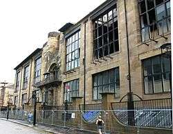
| Glasgow School of Art |
167 Renfrew Street and 11, 15 Dalhousie Street |
6 July 1966 |
NS5843565969 |
55°51′58″N 4°15′49″W / 55.866041°N 4.263746°W / 55.866041; -4.263746 (Glasgow School of Art) |
|
33105 |
 Upload another image
See more images
|
| 71-75 (Odd Nos) Robertson Street and 58, 60 Robertson Lane |
|
15 December 1970 |
NS5854265096 |
55°51′30″N 4°15′42″W / 55.858235°N 4.261582°W / 55.858235; -4.261582 (71-75 (Odd Nos) Robertson Street and 58, 60 Robertson Lane) |
|
33112 |
|
| Clyde Navigation Trust |
16 Robertson Street |
6 July 1966 |
NS5858664962 |
55°51′25″N 4°15′39″W / 55.857045°N 4.26081°W / 55.857045; -4.26081 (Clyde Navigation Trust) |
|
33113 |
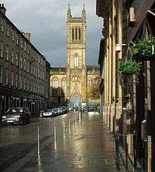
|
| St Aloysius' Church (Roman Catholic) |
23, 25 Rose Street |
15 December 1970 |
NS5855966016 |
55°51′59″N 4°15′42″W / 55.8665°N 4.261791°W / 55.8665; -4.261791 (St Aloysius' Church (Roman Catholic)) |
|
33115 |
 Upload another image
See more images
|
| Charing Cross Mansions |
2-30 (Even Nos) St George's Road, 540-546 (Even Nos) Sauchiehall Street and 357,359 Renfrew Street |
15 December 1970 |
NS5801766047 |
55°52′00″N 4°16′14″W / 55.866619°N 4.27046°W / 55.866619; -4.27046 (Charing Cross Mansions) |
|
33127 |
|
| 19-30 (Excluding Nos 23, 23A, 23B, 26A) St Vincent Crescent and 21 Corunna Street |
|
15 December 1970 |
NS5720465704 |
55°51′48″N 4°17′00″W / 55.863299°N 4.28326°W / 55.863299; -4.28326 (19-30 (Excluding Nos 23, 23A, 23B, 26A) St Vincent Crescent and 21 Corunna Street) |
|
33128 |
|
| 31-70 (Excluding Nos 35A,36A,37A,39A) St Vincent Crescent and 30 Corunna Street |
|
15 December 1970 |
NS5685865806 |
55°51′51″N 4°17′20″W / 55.864112°N 4.288837°W / 55.864112; -4.288837 (31-70 (Excluding Nos 35A,36A,37A,39A) St Vincent Crescent and 30 Corunna Street) |
|
33129 |
|
| 115, 117, St Vincent Street |
|
15 December 1970 |
NS5878765434 |
55°51′41″N 4°15′28″W / 55.861341°N 4.257847°W / 55.861341; -4.257847 (115, 117, St Vincent Street) |
|
33138 |
|
| St Vincent Street Church |
261 St Vincent Street |
6 July 1966 |
NS5831365551 |
55°51′44″N 4°15′56″W / 55.862253°N 4.265475°W / 55.862253; -4.265475 (St Vincent Street Church) |
Former United Free Church of Scotland, now Free Church |
33150 |
 Upload another image
See more images
|
| 84-94 (Even Nos) St Vincent Street |
|
15 December 1970 |
NS5890765456 |
55°51′42″N 4°15′21″W / 55.861574°N 4.255943°W / 55.861574; -4.255943 (84-94 (Even Nos) St Vincent Street) |
|
33153 |
|
| Bank of Scotland |
110, 120 St Vincent Street and 29-37 (Odd Nos) Renfield Street and West George Lane |
15 December 1970 |
NS5883665490 |
55°51′43″N 4°15′26″W / 55.861858°N 4.257094°W / 55.861858; -4.257094 (Bank of Scotland) |
|
33156 |
|
| Royal Bank Building |
140, 142 St Vincent Street and 153, 155 Hope Street |
21 July 1988 |
NS5874765494 |
55°51′43″N 4°15′31″W / 55.861868°N 4.258517°W / 55.861868; -4.258517 (Royal Bank Building) |
|
33159 |
|
| 142A, 144 St Vincent Street |
|
6 July 1966 |
NS5873765497 |
55°51′43″N 4°15′31″W / 55.861892°N 4.258678°W / 55.861892; -4.258678 (142A, 144 St Vincent Street) |
|
33160 |
|
| 200 St Vincent Street |
|
6 July 1966 |
NS5859665543 |
55°51′44″N 4°15′39″W / 55.862264°N 4.260953°W / 55.862264; -4.260953 (200 St Vincent Street) |
|
33162 |
 Upload another image
|
| Willow Tearooms |
217 Sauchiehall Street |
15 December 1970 |
NS5859465838 |
55°51′54″N 4°15′40″W / 55.864912°N 4.261139°W / 55.864912; -4.261139 (Willow Tearooms) |
|
33173 |
 Upload another image
See more images
|
| 901, 903 Sauchiehall Street |
|
15 December 1970 |
NS5712865932 |
55°51′55″N 4°17′05″W / 55.865323°N 4.284593°W / 55.865323; -4.284593 (901, 903 Sauchiehall Street) |
|
33184 |
|
| 336-356 (Even Nos) Sauchiehall Street and 1 Scott Street |
|
15 December 1970 |
NS5835265943 |
55°51′57″N 4°15′54″W / 55.865783°N 4.265057°W / 55.865783; -4.265057 (336-356 (Even Nos) Sauchiehall Street and 1 Scott Street) |
|
33193 |
|
| Albany Chambers |
528-538 (Even Nos) Sauchiehall Street |
15 December 1970 |
NS5804066017 |
55°51′59″N 4°16′12″W / 55.866356°N 4.270077°W / 55.866356; -4.270077 (Albany Chambers) |
|
33199 |
|
| The Egyptian Halls |
84-100 Union Street |
6 July 1966 |
NS5886165263 |
55°51′35″N 4°15′24″W / 55.859828°N 4.256577°W / 55.859828; -4.256577 (The Egyptian Halls) |
|
33208 |
 Upload another image
|
| Ca D'Oro Building |
122-136 (Even Nos) Union Street and 41-55 (Odd Nos) Gordon Street and Union Place |
15 December 1970 |
NS5886465320 |
55°51′37″N 4°15′24″W / 55.86034°N 4.256559°W / 55.86034; -4.256559 (Ca D'Oro Building) |
|
33209 |
 Upload another image
|
| Former Waterloo Street Post Office, Parcels Office |
50 Waterloo Street with 81 Wellington Street |
15 December 1970 |
NS5858365364 |
55°51′38″N 4°15′40″W / 55.860653°N 4.261067°W / 55.860653; -4.261067 (Former Waterloo Street Post Office, Parcels Office) |
|
33214 |
|
| Former Sun Life Building |
117, 121 West George Street and 38-42 (Even Nos) Renfield Street |
15 December 1970 |
NS5889365510 |
55°51′43″N 4°15′22″W / 55.862055°N 4.256195°W / 55.862055; -4.256195 (Former Sun Life Building) |
|
33223 |
|
| 4 Nelson Mandela Place |
|
15 December 1970 |
NS5904965538 |
55°51′44″N 4°15′13″W / 55.862352°N 4.253719°W / 55.862352; -4.253719 (4 Nelson Mandela Place) |
|
33233 |
 Upload another image
|
| Former Athenaeum |
8 Nelson Mandela Place |
6 July 1966 |
NS5902465544 |
55°51′45″N 4°15′15″W / 55.862398°N 4.254121°W / 55.862398; -4.254121 (Former Athenaeum) |
|
33234 |
|
| Royal Faculty of Procurators |
68 West George Street, 12 Nelson Mandela Place |
6 July 1966 |
NS5899265526 |
55°51′44″N 4°15′17″W / 55.862227°N 4.254622°W / 55.862227; -4.254622 (Royal Faculty of Procurators) |
|
33235 |
 Upload another image
|
| Cornhill House |
144, 146 West George Street |
15 December 1970 |
NS5882965580 |
55°51′46″N 4°15′26″W / 55.862664°N 4.257253°W / 55.862664; -4.257253 (Cornhill House) |
|
33241 |
|
| 196, 198 West George Street and 118 Wellington Street |
|
15 December 1970 |
NS5870265604 |
55°51′46″N 4°15′33″W / 55.862843°N 4.259293°W / 55.862843; -4.259293 (196, 198 West George Street and 118 Wellington Street) |
|
33246 |
|
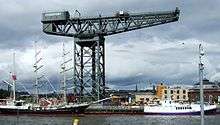
| Finnieston Crane |
Stobcross Quay |
14 April 1989 |
NS5710365150 |
55°51′30″N 4°17′04″W / 55.858295°N 4.28458°W / 55.858295; -4.28458 (Finnieston Crane) |
|
33285 |
 Upload another image
See more images
|
| 140, 142 Balgrayhill Road, including Redclyffe |
|
22 March 1977 |
NS6060768368 |
55°53′18″N 4°13′49″W / 55.888213°N 4.230303°W / 55.888213; -4.230303 (140, 142 Balgrayhill Road, including Redclyffe) |
|
33288 |
|
| Winter Gardens |
Springburn Park |
22 March 1985 |
NS6081468448 |
55°53′20″N 4°13′37″W / 55.888991°N 4.227037°W / 55.888991; -4.227037 (Winter Gardens) |
|
33298 |
 Upload another image
|
| Elder Cottage Hospital |
1A Drumoyne Drive and Langlands Road |
15 December 1970 |
NS5440865496 |
55°51′38″N 4°19′40″W / 55.860595°N 4.327783°W / 55.860595; -4.327783 (Elder Cottage Hospital) |
|
33300 |
|
| Statue of Mrs John Elder |
Elder Park |
15 December 1970 |
NS5455265587 |
55°51′41″N 4°19′32″W / 55.861455°N 4.325534°W / 55.861455; -4.325534 (Statue of Mrs John Elder) |
|
33304 |
 Upload another image
|
| Elder Park Library |
228A Langlands Road and Elder Park Street |
15 December 1970 |
NS5477765640 |
55°51′43″N 4°19′19″W / 55.861999°N 4.32197°W / 55.861999; -4.32197 (Elder Park Library) |
|
33310 |
|
| Govan Graving Docks |
18 Clydebrae Street |
15 May 1987 |
NS5609065462 |
55°51′39″N 4°18′03″W / 55.860795°N 4.300915°W / 55.860795; -4.300915 (Govan Graving Docks) |
|
33336 |
|
| Former British Linen Bank |
816, 818 Govan Road, 1, 3 Water Row |
15 December 1970 |
NS5542865763 |
55°51′48″N 4°18′42″W / 55.863299°N 4.311644°W / 55.863299; -4.311644 (Former British Linen Bank) |
|
33351 |
|
| Pearce Institute |
840, 860 Govan Road |
6 July 1966 |
NS5536265794 |
55°51′49″N 4°18′46″W / 55.863558°N 4.312714°W / 55.863558; -4.312714 (Pearce Institute) |
|
33352 |
|
| Govan Old Parish Church |
866, 868 Govan Road |
6 July 1966 |
NS5534965916 |
55°51′53″N 4°18′47″W / 55.864649°N 4.312986°W / 55.864649; -4.312986 (Govan Old Parish Church) |
|
33353 |
 Upload another image
See more images
|
| Govan Shipbuilders Ltd, General Offices |
1030, 1048 Govan Road |
15 December 1970 |
NS5468866024 |
55°51′56″N 4°19′25″W / 55.86542°N 4.323597°W / 55.86542; -4.323597 (Govan Shipbuilders Ltd, General Offices) |
Listing excludes the 1956 extension to the west. |
33356 |
|
| Govan Shipbuilders' Store, Former Engine Works of Fairfield Shipbuilding and Engineering Company |
1048 Govan Road |
15 May 1987 |
NS5468866024 |
55°51′56″N 4°19′25″W / 55.86542°N 4.323597°W / 55.86542; -4.323597 (Govan Shipbuilders' Store, Former Engine Works of Fairfield Shipbuilding and Engineering Company) |
|
33357 |
|
| Former Prince's Dock Hydraulic Power Station |
1 Pacific Quay |
15 December 1970 |
NS5690865009 |
55°51′25″N 4°17′15″W / 55.856972°N 4.287618°W / 55.856972; -4.287618 (Former Prince's Dock Hydraulic Power Station) |
|
33360 |
|
| The Knowe |
301 Albert Drive |
15 December 1970 |
NS5751663408 |
55°50′34″N 4°16′37″W / 55.842778°N 4.277073°W / 55.842778; -4.277073 (The Knowe) |
|
33371 |
|
| Miller and Lang Building |
50 Darnley Street, Pollokshields |
22 March 1977 |
NS5799763409 |
55°50′35″N 4°16′10″W / 55.842929°N 4.269398°W / 55.842929; -4.269398 (Miller and Lang Building) |
|
33402 |
|
| Pollokshields Burgh Hall |
70 and 72 Glencairn Drive |
15 December 1970 |
NS5685562973 |
55°50′19″N 4°17′15″W / 55.838677°N 4.28739°W / 55.838677; -4.28739 (Pollokshields Burgh Hall) |
|
33411 |
 Upload another image
|
| Ellisland |
200 Nithsdale Road |
15 December 1970 |
NS5693863352 |
55°50′32″N 4°17′11″W / 55.842104°N 4.286266°W / 55.842104; -4.286266 (Ellisland) |
|
33450 |
|
| Castlehill |
202 Nithsdale Road |
15 December 1970 |
NS5689263367 |
55°50′32″N 4°17′13″W / 55.842225°N 4.287007°W / 55.842225; -4.287007 (Castlehill) |
|
33451 |
|
| Pollok House |
2060 Pollokshaws Road |
6 July 1966 |
NS5490761802 |
55°49′39″N 4°19′04″W / 55.827582°N 4.317843°W / 55.827582; -4.317843 (Pollok House) |
|
33455 |
 Upload another image
See more images
|
| Bridge over White Cart Water at Pollok House |
2060 Pollokshaws Road |
6 July 1966 |
NS5488661731 |
55°49′37″N 4°19′05″W / 55.826939°N 4.31814°W / 55.826939; -4.31814 (Bridge over White Cart Water at Pollok House) |
|
33456 |
 Upload another image
|
| Stables of Pollok House |
2060 Pollokshaws Road |
6 July 1966 |
NS5499461661 |
55°49′35″N 4°18′59″W / 55.826343°N 4.31638°W / 55.826343; -4.31638 (Stables of Pollok House) |
|
33457 |
|
| Benefrey |
124 Springkell Avenue |
15 December 1970 |
NS5577763054 |
55°50′21″N 4°18′17″W / 55.839083°N 4.304632°W / 55.839083; -4.304632 (Benefrey) |
|
33486 |
|
| Former Caledonia Road Church |
1 Caledonia Road |
6 July 1966 |
NS5893263851 |
55°50′50″N 4°15′17″W / 55.847172°N 4.254709°W / 55.847172; -4.254709 (Former Caledonia Road Church) |
|
33497 |
 Upload another image
See more images
|
| 40-61 (Inclusive) Carlton Place and 16 Nicholson Street |
|
15 December 1970 |
NS5891664582 |
55°51′13″N 4°15′19″W / 55.85373°N 4.255344°W / 55.85373; -4.255344 (40-61 (Inclusive) Carlton Place and 16 Nicholson Street) |
|
33499 |
 Upload another image
|
| Former Eglinton Engine Works |
27-117 (Odd Nos) Cook Street (Westbridge Gardens) and 181 and 183 West Street |
17 June 1986 |
NS5830664278 |
55°51′03″N 4°15′54″W / 55.850822°N 4.264922°W / 55.850822; -4.264922 (Former Eglinton Engine Works) |
|
33504 |
|
| 162-170 (Even Nos) Gorbals Street |
|
15 December 1970 |
NS5896764171 |
55°51′00″N 4°15′16″W / 55.850055°N 4.254317°W / 55.850055; -4.254317 (162-170 (Even Nos) Gorbals Street) |
|
33513 |
|
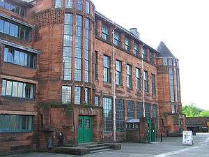
| Scotland Street School |
225 Scotland Street |
6 July 1966 |
NS5775264142 |
55°50′58″N 4°16′25″W / 55.849438°N 4.273692°W / 55.849438; -4.273692 (Scotland Street School) |
|
33534 |
 Upload another image
See more images
|
| Craigie Hall |
6 Rowan Road, Dumbreck |
27 April 1978 |
NS5554463935 |
55°50′49″N 4°18′32″W / 55.846923°N 4.308818°W / 55.846923; -4.308818 (Craigie Hall) |
|
33583 |
|
| Crookston Castle |
170 Brockburn Road |
6 November 1966 |
NS5255462721 |
55°50′06″N 4°21′21″W / 55.835119°N 4.35587°W / 55.835119; -4.35587 (Crookston Castle) |
|
33586 |
 Upload another image
See more images
|
| Leverndale Hospital, Towerview Unit |
510 Crookston Road |
15 December 1970 |
NS5162462691 |
55°50′04″N 4°22′14″W / 55.834565°N 4.370688°W / 55.834565; -4.370688 (Leverndale Hospital, Towerview Unit) |
|
33597 |
|
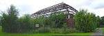
| Former Springburn College |
110-136 (Even Nos) Flemington Street |
29 January 1990 |
NS6056967426 |
55°52′47″N 4°13′50″W / 55.879745°N 4.230424°W / 55.879745; -4.230424 (Former Springburn College) |
|
33612 |
|
| Tollcross House |
591 Tollcross Road |
15 December 1970 |
NS6361963607 |
55°50′47″N 4°10′47″W / 55.84633°N 4.179787°W / 55.84633; -4.179787 (Tollcross House) |
|
33648 |
|
| Daldowie Dovecot |
Hamilton Road |
12 January 1971 |
NS6677762899 |
55°50′27″N 4°07′45″W / 55.840856°N 4.129041°W / 55.840856; -4.129041 (Daldowie Dovecot) |
|
33668 |
 Upload another image
|
| Southern Necropolis Lodge |
316 Caledonia Road, Rutherglen Road |
15 December 1970 |
NS5951163475 |
55°50′38″N 4°14′43″W / 55.843965°N 4.245274°W / 55.843965; -4.245274 (Southern Necropolis Lodge) |
The main cemetery is Category B. |
33685 |
 Upload another image
|
| St Francis Church and Presbytery |
405, 407 Cumberland Street |
15 December 1970 |
NS5949363749 |
55°50′47″N 4°14′45″W / 55.84642°N 4.245703°W / 55.84642; -4.245703 (St Francis Church and Presbytery) |
|
33690 |
|
| St Andrews Suspension Bridge |
Adelphi Street/Glasgow Green |
23 March 1992 |
NS5995964001 |
55°50′56″N 4°14′18″W / 55.848818°N 4.238397°W / 55.848818; -4.238397 (St Andrews Suspension Bridge) |
|
33692 |
 Upload another image
See more images
|
| Sentinel Works |
61 Jessie Street |
13 May 1991 |
NS5966662502 |
55°50′07″N 4°14′32″W / 55.835275°N 4.242298°W / 55.835275; -4.242298 (Sentinel Works) |
|
33693 |
|
| Aikenhead House |
325 Carmunnock Road, King's Park |
15 December 1970 |
NS5964060268 |
55°48′55″N 4°14′30″W / 55.81521°N 4.241558°W / 55.81521; -4.241558 (Aikenhead House) |
|
33708 |
|
| Ruchill Hospital, Water Tower |
520 Bilsland Drive |
6 April 1992 |
NS5838568292 |
55°53′13″N 4°15′57″W / 55.886882°N 4.265759°W / 55.886882; -4.265759 (Ruchill Hospital, Water Tower) |
|
33750 |
|
| Kelvin Stevenson Memorial Church |
62 Belmont Street, 93 and 99 Garriochmill Road |
15 December 1970 |
NS5753367233 |
55°52′38″N 4°16′44″W / 55.877123°N 4.278812°W / 55.877123; -4.278812 (Kelvin Stevenson Memorial Church) |
Church of Scotland |
33753 |
|
| Queens Cross Church and Hall |
870 Garscube Road |
6 July 1966 |
NS5797667572 |
55°52′49″N 4°16′19″W / 55.880298°N 4.271915°W / 55.880298; -4.271915 (Queens Cross Church and Hall) |
|
33764 |
 Upload another image
See more images
|
| St Columba of Iona Roman Catholic Church and Presbytery |
74 and 76 Hopehill Road |
6 April 1992 |
NS5829567132 |
55°52′35″N 4°16′00″W / 55.876441°N 4.26659°W / 55.876441; -4.26659 (St Columba of Iona Roman Catholic Church and Presbytery) |
|
33765 |
 Upload another image
See more images
|
| Former St George In The Fields |
485 St George's Road |
6 July 1966 |
NS5845866865 |
55°52′27″N 4°15′50″W / 55.874092°N 4.263847°W / 55.874092; -4.263847 (Former St George In The Fields) |
|
33782 |
 Upload another image
See more images
|
| St Mary's Roman Catholic Church |
99 Abercromby Street |
16 March 1993 |
NS6070064541 |
55°51′14″N 4°13′37″W / 55.853881°N 4.226849°W / 55.853881; -4.226849 (St Mary's Roman Catholic Church) |
|
33810 |
|
| 105-169 (Odd Nos) Bell Street |
|
22 March 1977 |
NS5976064987 |
55°51′27″N 4°14′31″W / 55.857612°N 4.242083°W / 55.857612; -4.242083 (105-169 (Odd Nos) Bell Street) |
|
33814 |
|
| Shelter |
Bridgeton Cross |
16 March 1993 |
NS6070963997 |
55°50′56″N 4°13′35″W / 55.848999°N 4.226426°W / 55.848999; -4.226426 (Shelter) |
|
33818 |
 Upload another image
|
| Alexander's School |
94 Duke Street |
15 December 1970 |
NS6018265190 |
55°51′34″N 4°14′08″W / 55.859557°N 4.235451°W / 55.859557; -4.235451 (Alexander's School) |
Previously used as an annex by St Mungo's Academy. Currently housing small businesses. |
33827 |
|
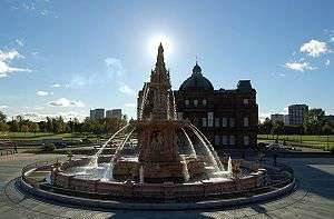
| Doulton Fountain |
Glasgow Green |
15 December 1970 |
NS6010564314 |
55°51′06″N 4°14′10″W / 55.85167°N 4.236229°W / 55.85167; -4.236229 (Doulton Fountain) |
|
33836 |
 Upload another image
See more images
|
| Nelson Monument |
Glasgow Green |
15 December 1970 |
NS5982464302 |
55°51′05″N 4°14′27″W / 55.851481°N 4.240707°W / 55.851481; -4.240707 (Nelson Monument) |
|
33837 |
 Upload another image
See more images
|
| People's Palace |
Glasgow Green |
15 December 1970 |
NS6002964265 |
55°51′04″N 4°14′15″W / 55.851208°N 4.237416°W / 55.851208; -4.237416 (People's Palace) |
|
33838 |
 Upload another image
See more images
|
| Mercat Building |
15-23 (Odd Nos) London Road and 26 Gallowgate |
15 December 1970 |
NS5969064845 |
55°51′23″N 4°14′35″W / 55.856317°N 4.243127°W / 55.856317; -4.243127 (Mercat Building) |
|
33851 |
|
| Church of The Sacred Heart |
50-56 (Even Nos) Old Dalmarnock Road |
15 December 1970 |
NS6089863678 |
55°50′46″N 4°13′24″W / 55.84619°N 4.223246°W / 55.84619; -4.223246 (Church of The Sacred Heart) |
|
33855 |
|
| Templeton Carpet Factory |
62 Templeton Street |
6 July 1966 |
NS6032564163 |
55°51′01″N 4°13′58″W / 55.850378°N 4.23264°W / 55.850378; -4.23264 (Templeton Carpet Factory) |
|
33857 |
 Upload another image
See more images
|
| 17 Watson Street |
|
15 December 1970 |
NS5973264909 |
55°51′25″N 4°14′33″W / 55.856904°N 4.24249°W / 55.856904; -4.24249 (17 Watson Street) |
|
33862 |
|
| Provan Hall |
Auchinlea Park, Easterhouse |
15 December 1970 |
NS6675566324 |
55°52′18″N 4°07′52″W / 55.871601°N 4.131076°W / 55.871601; -4.131076 (Provan Hall) |
|
33863 |
 Upload another image
|
| Gartloch Hospital |
Gartloch Road |
14 June 1991 |
NS6835967134 |
55°52′46″N 4°06′21″W / 55.879315°N 4.105854°W / 55.879315; -4.105854 (Gartloch Hospital) |
|
33868 |
|
| Walmer Crescent |
Cessnock |
6 July 1966 |
NS5632364465 |
55°51′07″N 4°17′48″W / 55.851914°N 4.296668°W / 55.851914; -4.296668 (Walmer Crescent) |
|
33876 |
|
| St Andrew's East Church |
681 Alexandra Parade and 6 Easter Craigs |
15 December 1970 |
NS6187565529 |
55°51′47″N 4°12′31″W / 55.863089°N 4.208598°W / 55.863089; -4.208598 (St Andrew's East Church) |
|
33879 |
 Upload another image
|
| Cast-iron Fountain |
Alexandra Park |
17 June 1992 |
NS6190065687 |
55°51′52″N 4°12′30″W / 55.864515°N 4.208279°W / 55.864515; -4.208279 (Cast-iron Fountain) |
|
33880 |
 Upload another image
|
| The Necropolis |
Cathedral Square |
15 December 1970 |
NS6048265549 |
55°51′46″N 4°13′51″W / 55.862868°N 4.230847°W / 55.862868; -4.230847 (The Necropolis) |
|
33890 |
 Upload another image
See more images
|
| Our Lady of Good Counsel Roman Catholic Church |
73 Craigpark |
23 September 1994 |
NS6101065499 |
55°51′45″N 4°13′21″W / 55.862571°N 4.222392°W / 55.862571; -4.222392 (Our Lady of Good Counsel Roman Catholic Church) |
|
33891 |
|
| 176 Duke Street, Kirkhaven |
|
15 December 1970 |
NS6052765091 |
55°51′32″N 4°13′48″W / 55.858769°N 4.229893°W / 55.858769; -4.229893 (176 Duke Street, Kirkhaven) |
|
33899 |
|
| St Anne's Church and Presbytery |
17-23 (Odd Nos) Whitevale Street |
27 November 1979 |
NS6139464936 |
55°51′27″N 4°12′58″W / 55.857627°N 4.215974°W / 55.857627; -4.215974 (St Anne's Church and Presbytery) |
|
33912 |
|
| 52-54 (Even Nos) Langside Drive |
|
19 March 1991 |
NS5731560342 |
55°48′55″N 4°16′43″W / 55.815193°N 4.278669°W / 55.815193; -4.278669 (52-54 (Even Nos) Langside Drive) |
|
33936 |
|
| Former Waverley Cinema |
18 Moss-Side Road |
17 June 1992 |
NS5718062130 |
55°49′52″N 4°16′54″W / 55.831205°N 4.281761°W / 55.831205; -4.281761 (Former Waverley Cinema) |
|
33941 |
|
| Holmwood House |
61, 63 Netherlee Road |
17 June 1967 |
NS5850559695 |
55°48′35″N 4°15′34″W / 55.809734°N 4.259358°W / 55.809734; -4.259358 (Holmwood House) |
|
33944 |
 Upload another image
See more images
|
| Pollokshaws Burgh Hall |
2025 Pollokshaws Road |
15 December 1970 |
NS5612561514 |
55°49′31″N 4°17′54″W / 55.825362°N 4.298264°W / 55.825362; -4.298264 (Pollokshaws Burgh Hall) |
|
33953 |
|
| Anniesland Court |
833-861 (Odd Nos) Crow Road, Anniesland |
2 April 1996 |
NS5467368865 |
55°53′27″N 4°19′31″W / 55.89092°N 4.325361°W / 55.89092; -4.325361 (Anniesland Court) |
|
43034 |
 Upload another image
|
| St Andrew's East Church Hall |
685 Alexandra Parade |
15 December 1970 |
NS6189565518 |
55°51′47″N 4°12′30″W / 55.862996°N 4.208273°W / 55.862996; -4.208273 (St Andrew's East Church Hall) |
|
48569 |
|
| Scottish Ambulance Service station and St Andrew's House, St Andrew's Ambulance Association |
30 Maitland Street and 54 Milton Street |
7 February 2005 |
NS5888166138 |
55°52′04″N 4°15′24″W / 55.867689°N 4.256713°W / 55.867689; -4.256713 (Scottish Ambulance Service station and St Andrew's House, St Andrew's Ambulance Association) |
|
50073 |
 Upload another image
|
| Burrell Collection |
2060 Pollokshaws Road, Pollok Country Park |
23 January 2013 |
NS5548662138 |
55°49′51″N 4°18′27″W / 55.830833°N 4.3075°W / 55.830833; -4.3075 (Burrell Collection) |
|
52002 |
 Upload another image
See more images
|