Lindrith, New Mexico
| Lindrith, New Mexico | |
|---|---|
| Unincorporated community | |
 Lindrith, New Mexico | |
| Coordinates: 36°18′16″N 107°02′42″W / 36.30444°N 107.04500°WCoordinates: 36°18′16″N 107°02′42″W / 36.30444°N 107.04500°W | |
| Country | United States |
| State | New Mexico |
| County | Rio Arriba |
| Elevation | 7,237 ft (2,206 m) |
| Time zone | Mountain (MST) (UTC-7) |
| • Summer (DST) | MDT (UTC-6) |
| ZIP code | 87029 |
| Area code(s) | 505 |
| GNIS feature ID | 907972[1] |
Lindrith is an unincorporated community in Rio Arriba County, New Mexico, United States.[1] Lindrith is located in southern Rio Arriba County along New Mexico State Road 95. Lindrith has a post office with ZIP code 87029.[2][3] The Lindrith Airpark, a public-use airport, is located in Lindrith.[4] Lindrith has a charter elementary school, the Lindrith Area Heritage School.[5][6]
References
- 1 2 "Lindrith". Geographic Names Information System. United States Geological Survey.
- ↑ United States Postal Service (2012). "USPS - Look Up a ZIP Code". Retrieved 2012-02-15.
- ↑ "Postmaster Finder - Post Offices by ZIP Code". United States Postal Service. Retrieved August 24, 2013.
- ↑ "Lindrith Airpark". Airport IQ 5010. Retrieved August 24, 2013.
- ↑ "L.A.H.S.". Lindrith Area Heritage School. Retrieved August 24, 2013.
- ↑ "Lindrith Area Heritage". GreatSchools. Retrieved August 24, 2013.
Municipalities and communities of Rio Arriba County, New Mexico, United States | ||
|---|---|---|
| City | 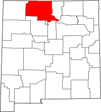 | |
| Village | ||
| CDPs |
| |
| Other unincorporated communities | ||
| Ghost towns and former settlements | ||
| Indian reservation | ||
| Footnotes | ‡This populated place also has portions in an adjacent county or counties | |
This article is issued from Wikipedia - version of the 7/30/2014. The text is available under the Creative Commons Attribution/Share Alike but additional terms may apply for the media files.