Licking Township, Blackford County, Indiana
| Licking Township | |
|---|---|
| Township | |
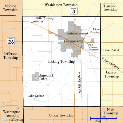
 Location of Licking Township in Blackford County | |
| Coordinates: 40°26′00″N 85°23′14″W / 40.43333°N 85.38722°WCoordinates: 40°26′00″N 85°23′14″W / 40.43333°N 85.38722°W | |
| Country | United States |
| State | Indiana |
| County | Blackford |
| Government | |
| • Type | Indiana township |
| Area | |
| • Total | 41.46 sq mi (107.4 km2) |
| • Land | 41.18 sq mi (106.7 km2) |
| • Water | 0.28 sq mi (0.7 km2) |
| Elevation[1] | 873 ft (266 m) |
| Population (2010) | |
| • Total | 7,899 |
| • Density | 191.8/sq mi (74.1/km2) |
| FIPS code | 18-43650[2] |
| GNIS feature ID | 453568 |
Licking Township is one of four townships in Blackford County, Indiana. As of the 2010 census, its population was 7,899 and it contained 3,885 housing units.[3] The township was named after Lick Creek and a salt lick in the area. The first settlers in what became Blackford County arrived in the Lick Creek area in 1831.[4]
Geography
According to the 2010 census, the township has a total area of 41.46 square miles (107.4 km2), of which 41.18 square miles (106.7 km2) (or 99.32%) is land and 0.28 square miles (0.73 km2) (or 0.68%) is water.[3] Cains Lake and Lake Mohee are in this township. Lick Creek flows through the township.
Cities and towns
Unincorporated towns
Major highways
Cemeteries
The township contains at least seven cemeteries: Cunningham, Greenlawn, Independent Order of Odd Fellows, Lion, Sprague, Stewart, and Willman (a.k.a. Hartford City Cemetery).
Notes
- ↑ "US Board on Geographic Names". United States Geological Survey. 2007-10-25. Retrieved 2008-01-31.
- ↑ "American FactFinder". United States Census Bureau. Archived from the original on September 11, 2013. Retrieved 2008-01-31.
- 1 2 "Population, Housing Units, Area, and Density: 2010 - County -- County Subdivision and Place -- 2010 Census Summary File 1". United States Census. Retrieved 2013-05-10.
- ↑ See “A History of Blackford County, Indiana…”, page 140.
References
- A History of Blackford County, Indiana : with historical accounts of the county, 1838-1986 [and] histories of families who have lived in the county. Hartford City, Indiana: Blackford County Historical Society. 1986. p. 302. OCLC 15144953.
- Biographical and historical record of Jay and Blackford Counties, Indiana: Containing ... portraits and biographies of some of the prominent men of the state : engravings of prominent citizens in Jay and Blackford Counties, with personal histories of many of the leading families and a concise history of Jay and Blackford Counties and their cities and villages. Chicago: The Lewis Publishing Company. 1887. OCLC 15560416.
- "Licking Township, Blackford County, Indiana". Geographic Names Information System. United States Geological Survey. Retrieved 2009-09-24.
- United States Census Bureau cartographic boundary files
External links

Municipalities and communities of Blackford County, Indiana, United States | ||
|---|---|---|
| Cities | ||
| Town | ||
| Townships | ||
| Unincorporated communities | ||
| Footnotes | ‡This populated place also has portions in an adjacent county or counties | |