Lesnes Abbey


Lesnes Abbey /ˈlɛsnᵻs/ is a former abbey, now ruined, in Abbey Wood, in the London Borough of Bexley, southeast London, England. It is a scheduled ancient monument[1] and the adjacent Lesnes Abbey Woods are a Local Nature Reserve.[2] Part of the wood is the Abbey Wood SSSI, a geological Site of Special Scientific Interest which is an important site for early Tertiary fossils.[3]
History
After the Norman Conquest of 1066, the area of Lesnes, close to the town of Erith, passed into the possession of Bishop Odo and is mentioned in the Domesday Survey. The year 1178 saw the foundation of the Abbey of St Mary and St Thomas the Martyr at Lesnes.
Lesnes Abbey, as it is known, was founded by Richard de Luci, Chief Justiciar of England, in 1178. It is speculated, this may have been in penance for the murder of Thomas Becket, in which he was involved. In 1179, de Luci resigned his office and retired to the Abbey, where he died three months later. He was buried in the chapter house.
The abbey is situated in the suburbs of south east London, in the north of an ancient but long-managed Lesnes Abbey Woods that are named after it, where the land rises above what would originally have been marshland.
In 1381 Abel Ker of Erith led a local uprising linked to the famous Peasants' Revolt. It actually began in Essex but a mob from Erith burst into nearby Lesnes Abbey and forced the abbot to swear an oath to support them. After this they marched to Maidstone to join the main body of men led by Wat Tyler.[4]
The Abbott of Lesnes Abbey was an important local landlord, and took a leading part in draining the marshland. However, this and the cost of maintaining river embankments was one of the reasons given for the Abbey's chronic financial difficulties. It never became a large community, and was closed by Cardinal Wolsey in 1525, under a licence to suppress monasteries of less than seven inmates. It was one of the first monasteries to be closed after the Dissolution of the Monasteries in 1524, and the monastic buildings were all pulled down, except for the Abbott's Lodging. Henry Cooke acquired the site in 1541 and it eventually passed to Sir John Hippersley who salvaged building materials, before selling the property to Thomas Hawes of London in 1632. It was then bequeathed to Christ's Hospital in 1633. Some of the stone is said to have been used in the construction of Hall Place in nearby Bexley.
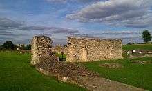
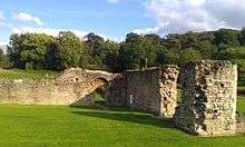
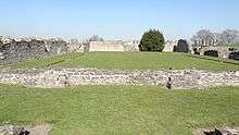
The abbey was effectively lost and the area became farmland with the abbots house forming part of a farmhouse. It has been restored to show some of the walls and the entire outline of the abbey is visible giving a good idea of the size and atmosphere of the original place. It is on the Green Chain Walk and surrounded by parkland and an ornamental garden. There is a cafe and a small exhibition of the abbey and also toilet facilities for visitors.
There is a large externally propped mulberry tree (Morus nigra) at the northern side of the abbey.
The site was excavated by Woolwich & District Antiquarian Society in 1909-1910 approx.[5] Some archaeological finds from the Abbey's site are displayed in Plumstead Museum at 232 Plumstead High Street, others are further east in the museum above Erith Library in Walnut Tree Road. The "Missale de Lesnes" is in the library of the Victoria & Albert Museum in Exhibition Road, London.
The former London County Council purchased the site of the ruins in 1930, which were opened to the public as a park in 1931. Since 1986, the site has been the property of the London Borough of Bexley. A branch of the Green Chain Walk passes the ruins on its way from Oxleas Wood to Thamesmead riverside.
Lesnes Abbey ward
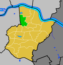
Today Lesnes Abbey gives its name to one of the 21 electoral wards that the London Borough of Bexley is divided into. The ruins themselves are in the north of Lesnes Abbey ward. Woolwich Road, the A206 road cuts through the middle of the ward spanning east to west; the A2041 road spans north to south marking the ward's western boundary. West Heath is located within the ward to the south of Woolwich road. Lesnes Abbey ward is 2.5 km (1.6 mi) long north to south at its longest point, and little under 1.5 km (0.93 mi) at its widest point east to east. The population of the ward at the 2011 Census was 11,346.[6]
References
- ↑ London Gardens Online, Lesnes Abbey
- ↑ Natural England, Local Nature Reserves, Lesnes Abbey Woods
- ↑ Natural England citation, Abbey Wood
- ↑ "Erith" (PDF). UK: London Borough of Bexley. Retrieved 27 September 2015.
- ↑ Woolwich and District Antiquarian Society, "Report on Explorations at Lesnes Abbey Kent", several volumes 1909 to 1912
- ↑ "Bexley Ward population 2011". Neighbourhood Statistics. Office for National Statistics. Retrieved 14 October 2016.
External links
| Wikimedia Commons has media related to Lesnes Abbey. |
- Bexley Abbey ruins, London Borough of Bexley
- Lesnes Abbey Conservation Volunteers (LACV)
- Houses of Austin canons: The abbey of Lesnes or Westwood. A History of the County of Kent. 2. 1926. pp. 165–167. Retrieved 5 December 2007.
| Districts |
|  |
|---|---|---|
| Attractions |
| |
| Parks and open spaces |
| |
| Constituencies | ||
| Rail stations | ||
| Other topics | ||
Coordinates: 51°29′19″N 0°7′44″E / 51.48861°N 0.12889°E