Leekfrith

Leekfrith is a civil parish in the Staffordshire Moorlands, in Staffordshire, England, north of the town of Leek. The population of the civil parish at the 2011 census was 363.[1]
It is an area between the River Churnet which is near Leek, and the River Dane (the boundary with Cheshire) and its tributary Black Brook. The civil parishes of Heaton and Tittesworth are to the west and east.
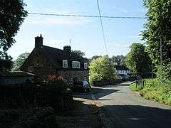
The area includes the villages of Abbey Green and Meerbrook, the Roaches, a rocky ridge in the north-east, and most of Tittesworth Reservoir. A chasm known as Lud's Church is near the River Dane; A hill named Gun is at the western boundary. The village of Upper Hulme is near the eastern boundary.
The ground is of boulder clay, and the underlying rock is millstone grit. The soil is loam and clay. The land is used mostly as pasture.
History
The word frith means a wood; much of the area was wooded countryside in medieval times, and some survives north-east of Abbey Green.
Dieulacres Abbey, near the present Abbey Green, was founded by Ranulf de Blondeville, 6th Earl of Chester, lord of the manor of Leek. In about 1220 the Earl granted the monks an area known as the Rudyard Estate, in the south-west of Leekfrith, where the abbey was built. The village of Abbey Green probably began as an open space at the abbey gate. The abbey owned monastic granges in Leekfrith at Roche Grange, Wetwood and Foker.
Dieulacres Abbey was surendered in 1538 at the dissolution of the monasteries, and the present Abbey Farm stands on part of the site.
References
- ↑ "Civil Parish population 2011". Retrieved 1 December 2015.
- A P Baggs, M F Cleverdon, D A Johnston and N J Tringham, 'Leek: Leekfrith', in A History of the County of Stafford: Volume 7, Leek and the Moorlands, ed. C R J Currie and M W Greenslade (London, 1996), pp. 191-202 British History Online, accessed 18 May 2015.
Coordinates: 53°9′N 2°1′W / 53.150°N 2.017°W
| Unitary authorities | |
|---|---|
| Boroughs or districts | |
| Major settlements | |
| Rivers | |
| Canals | |
| Topics | |