South Staffordshire
| South Staffordshire District | |
|---|---|
| Non-metropolitan district | |
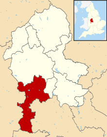 South Staffordshire shown within Staffordshire | |
| Sovereign state | United Kingdom |
| Constituent country | England |
| Region | West Midlands |
| Non-metropolitan county | Staffordshire |
| Status | Non-metropolitan district |
| Admin HQ | Codsall |
| Incorporated | 1 April 1974 |
| Government | |
| • Type | Non-metropolitan district council |
| • Body | South Staffordshire District Council |
| • Leadership | Leader & Cabinet (Conservative) |
| • MPs |
Gavin Williamson Jeremy Lefroy |
| Area | |
| • Total | 157.3 sq mi (407.3 km2) |
| Area rank | 101st (of 326) |
| Population (mid-2014 est.) | |
| • Total | 110,692 |
| • Rank | 211th (of 326) |
| • Density | 700/sq mi (270/km2) |
| • Ethnicity | 98.0% White |
| Time zone | GMT (UTC0) |
| • Summer (DST) | BST (UTC+1) |
| ONS code |
41UF (ONS) E07000196 (GSS) |
| OS grid reference | SJ8701803171 |
| Website |
www |
South Staffordshire is a local government district in Staffordshire, England. The district lies to the north and west of the West Midlands county, bordering Shropshire to the west and Worcestershire to the south. It contains no towns of major size, and many of the settlements within the district are considered dormitory villages for Stafford, Telford, and the West Midlands conurbation.
The district was formed on 1 April 1974, under the Local Government Act 1972, by the merger of Cannock Rural District (in the north) and Seisdon Rural District (in the south).
Its council is based in Codsall,[1] one of the larger settlements in the district, along with Brewood, Cheslyn Hay, Great Wyrley, Kinver, Landywood, Penkridge, Perton and Wombourne. Other villages in the district include Coven, Essington, Featherstone, Gospel End, Huntington, Lower Penn, Pattingham, Seisdon and Trysull.
The district covers a similar geographic area to South Staffordshire parliamentary constituency, although the north of the district is covered by the Stafford constituency. Sir Patrick Cormack of the Conservative Party held the South Staffordshire seat, and its predecessor, Staffordshire South-West, between 1974–2010, when he retired and the seat was won by Gavin Williamson for the Conservative Party.
Countryside
There are many beauty spots within the South Staffordshire district, for example the village of Wombourne has the Wom Brook Walk and the Bratch Locks on the Staffordshire and Worcestershire Canal in the nearby village of Bratch. Other sites include:
- South Staffordshire Railway Walk: A 5.5 miles (8.9 km) walk along the disused railway line of the Wombourne Branch Line.[2]
- Baggeridge Country Park: A large and diverse country park located between Wombourne and Sedgley (in the Dudley Metropolitan Borough), which has won the national Green Flag Award for 11 years.[3]
- Bluebell Woods, Perton: An internationally important site for Bluebells.[4]
- Highgate Common: A large area of heathland near Swindon.
- Kinver Edge: A National Trust property, located in the south of the district which features the Holy Austin Rock Houses.[5]
- Shoal Hill Common: A 180-acre (0.73 km2) site of lowland heaths and woodlands which can be found to the extreme north of the district.
Bunkers Tree Wood is also in the area and contains a large Corvid roost.
Local Government
As of March 2011, the political make-up of the local council was as follows:[6]
| Party | Number of Councillors | |
| Conservative | 42 | |
| Independent | 5 | |
| Labour | 1 | |
| Liberal Democrats | 1 | |
References
- ↑ "South Staffordshire Council: Directions" (PDF). Retrieved 16 October 2016.
- ↑ "South Staffordshire Railway". Leisure Services. South Staffordshire Council. Retrieved 28 February 2014.
- ↑ "Baggeridge County Park". South Staffordshire Council. Retrieved 16 October 2016.
- ↑ "Bluebell Walk at Smith's Rough". South Stafforshire Council. Retrieved 2010-01-20.
- ↑ "Kinver Edge and the Rock Houses". National Trust. Retrieved 16 October 2016.
- ↑ "Archived copy". Archived from the original on 19 March 2012. Retrieved 2012-04-28.
| Unitary authorities | |
|---|---|
| Boroughs or districts | |
| Major settlements | |
| Rivers | |
| Canals | |
| Topics | |
Districts of the West Midlands Region | ||
|---|---|---|
| Herefordshire |  | |
| Shropshire | ||
| Staffordshire | ||
| Warwickshire | ||
| West Midlands | ||
| Worcestershire | ||
Coordinates: 52°37′33″N 2°11′30″W / 52.6258°N 2.1918°W