Lawrence, New Zealand
| Lawrence | |
|---|---|
| Town | |
|
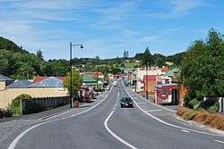
Ross Place (State Highway 89), the main street of Lawrence | |
 Lawrence | |
| Coordinates: 45°54′S 169°41′E / 45.900°S 169.683°ECoordinates: 45°54′S 169°41′E / 45.900°S 169.683°E | |
| Country | New Zealand |
| Region | Otago |
| Territorial authority | Clutha District |
| Population (2006)[1] | |
| • Total | 435 |
| Time zone | New Zealand Standard Time (UTC+12) |
| • Summer (DST) | New Zealand Daylight Time (UTC+13) |
| Postcode | 9532 |
Lawrence is a small town of 474 inhabitants (as per the 2001 census) in Otago, in New Zealand's South Island. It is located on State Highway 8, the main route from Dunedin to the inland towns of Queenstown and Alexandra. It lies 35 kilometres to the northwest of Milton, 11 kilometres northwest of Waitahuna, and close to the Tuapeka River, a tributary of the Clutha.
Lawrence's main claim to fame is of being the focal point for Otago's 1860s gold rush, after the discovery of the metal at nearby Gabriel's Gully by Gabriel Read. In mid-1862, it is estimated that twice as many people lived around the banks of the Tuapeka River as did in Dunedin itself. Additionally, the tune to New Zealand's national anthem was composed in Lawrence by John J. Woods, a Lawrence school teacher.[2]
The town was named for Sir Henry Lawrence, hero of the Lucknow military campaign of 1857, and is billed as "The Gateway To Central Otago".
In 1877, a branch line railway was built from the Main South Line to Lawrence, and the town remained the terminus of the line until an extension was built in 1910. Although originally known as the Lawrence Branch, this line ultimately became known as the Roxburgh Branch. The railway closed in 1968 and the town's station has subsequently been demolished, but some relics still remain, including the goods shed.
In 1978, two lions named Sultan and Sonia escaped from a circus in Lawrence. The circus' tranquiliser guns had accidentally been left behind in another town so they could not be shot with tranqiliser darts. They were eventually shot by police but not before one of them had scratched a seven-year-old boy across the face.[3] The lions were stuffed and are now on display at Otago Museum.
Lawrence's sister city is Jacksonville, Oregon.
The Lawrence Rugby Football Club is a big part of the town.
Lawrence is the first town in New Zealand to offer town-wide free WiFi internet.[4]
Education
Lawrence Area School is a state composite (Year 1–13) school serving the town, with a roll of 141 students as of July 2016.[5]
Lawrence Area School was a high school until the 1960s, when it became an area school catering to primary pupils as well. There were other primary schools previously in Lawrence. Blue Spur School closed some time in the 1930s or 40s; Forsythe School closed in the 1960s; and St Patrick's School closed at the end of 1980, leaving Lawrence Area School as the sole remaining school in Lawrence. In addition to pupils from Lawrence, Lawrence Area provides secondary education for pupils from Waitahuna and Beaumont, which only have primary schools.
Notable Residents
- Archibald Durward FRSE (1902-1964) spent his youth here. He was the son of the local minister Rev Peter C. Durward.
References
- Wise's New Zealand guide: A gazeteer of New Zealand (4th ed.) (1969) Dunedin: H. Wise & Co. (N.Z.) Ltd.
- ↑ "QuickStats About Lawrence". 2006 Census. Statistics New Zealand. Retrieved 8 January 2012.
- ↑ New Zealand's National Anthem's history - Ministry for Culture and Heritage
- ↑ "The Lawrence Lions". Otago Museum.
- ↑ "Small town maintains pioneering streak". One News. 2 May 2009. Retrieved 14 October 2011.
- ↑ "Directory of Schools - as at 2 August 2016". New Zealand Ministry of Education. Retrieved 2016-08-16.
External links
![]() Media related to Lawrence, New Zealand at Wikimedia Commons
Media related to Lawrence, New Zealand at Wikimedia Commons