Lambussie Karni District
| Lambussie Karni District | |
|---|---|
| District | |
 Districts of Upper West region | |
 Lambussie Karni District Lambussie Karni District in Upper West region | |
| Coordinates: 10°20′N 2°20′W / 10.333°N 2.333°W | |
| Region | Upper West Region |
| Capital | Lambussie |
| Government | |
| • District chief executive | Kofi Bom D-yaka |
| Area | |
| • Land | 1,356.6 km2 (523.8 sq mi) |
| Population (2013) | |
| • Total | — |
| Time zone | Greenwich Mean Time (UTC+0) |
| • Summer (DST) | GMT (UTC) |
| ISO 3166 code | GH-UW-LK |
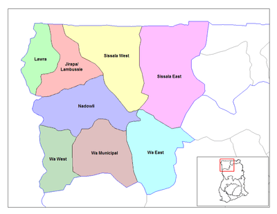
The Lambussie Karni District[1] is one of the eleven (11) districts in the Upper West Region of north Ghana. The capital is Lambussie. The district was created in 2008, and was inaugurated on 29 February 2008.The District is located in the North Western corner of the Upper West Region of Ghana. It lies approximately between Latitudes 10.250 and 11.000 North and Longitudes 20.250 and 20.400 West. It is the smallest District in the Region and covers a total land area of 1,356.6 km2. It contributes about 6% of the Region’s land area which is 18,476 km2. It is extends from Hamile in the North to Karni in the South.
It is bordered to the South by the Jirapa District, to the North by Ghana’s boundary with Burkina Faso, to the West by the Lawra District and to the East by the Sissala West District. The District capital, Lambussie is about 92 km away from Wa, the Regional capital.
Sources
- "Districts of Ghana". Statoids.
- GhanaDistricts.com
References
| Municipal |
| |
|---|---|---|
| District |
| |
Coordinates: 10°20′N 2°20′W / 10.333°N 2.333°W