Jirapa/Lambussie District
| Jirapa/Lambussie District | |
|---|---|
| District | |
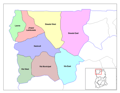 Districts of Upper West region | |
 Jirapa/Lambussie District Jirapa/Lambussie District in Upper West region | |
| Coordinates: 10°32′02″N 02°42′00″W / 10.53389°N 2.70000°W | |
| Region | Upper West Region |
| Capital | Jirapa |
| Government | |
| • District executive | Justine Bayelah Dakurah |
| Area | |
| • Total | 2,125 km2 (820 sq mi) |
| Population (2013) | |
| • Total | — |
| Time zone | Greenwich Mean Time (UTC+0) |
| • Summer (DST) | GMT (UTC) |
| ISO 3166 code | GH-UW-JL |
The Jirapa/Lambussie District is one of the nine (9) districts in the Upper West Region of north Ghana. The capital is Jirapa.
Geography
Jirapa/Lambussie District lies in the northwestern corner of the Upper West Region of Ghana. It shares boundaries to the south with Nadowli District, to the east with Sissala East District, and to the west with Lawra District.
Economy
About eighty percent (80%) of the population are engaged in agriculture and other related activities. The major crops are millet, maize, cotton and groundnuts. Livestock farming is practiced throughout the district.
Education
Within the Jirapa/Lambussie District there are several schools for both boys and girls. St. Francis Girls' Secondary School Jirapa is the only girls' secondary school in the district.
Demographics and population
Demographics
About five percent (5%) of the people live in major towns of the District while a significant ninety-five percent (95%) live in rural settlements. The District is therefore considered as a rural district.
Sources
- "Districts of Ghana". Statoids.
- GhanaDistricts.com
| Municipal |
| |
|---|---|---|
| District |
| |
Coordinates: 10°32′02″N 2°42′00″W / 10.53389°N 2.70000°W