Lamberhurst
| Lamberhurst | |
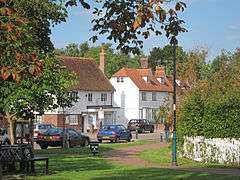 The Broadway |
|
 Lamberhurst |
|
| Population | 1,706 (2011 Census)[1] |
|---|---|
| OS grid reference | TQ6736 |
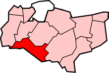
| Civil parish | Lamberhurst |
| District | Tunbridge Wells |
| Shire county | Kent |
| Region | South East |
| Country | England |
| Sovereign state | United Kingdom |
| Post town | TUNBRIDGE WELLS |
| Postcode district | TN3 |
| Dialling code | 01892 |
| Police | Kent |
| Fire | Kent |
| Ambulance | South East Coast |
| EU Parliament | South East England |
| UK Parliament | Tunbridge Wells |
Coordinates: 51°05′49″N 0°23′35″E / 51.097°N 0.393°E
Lamberhurst (/ˈlæmbərhɜːrst/ is a village and civil parish in Kent containing the hamlets of The Down and Hook Green. At the 2001 census it had a population of 1,491,[2] increasing to 1,706 at the 2011 Census.[1]
History

Prior to the Industrial Revolution, Lamberhurst was a centre for the Wealden iron industry, originally set up during Roman times. Since then it had some importance for the hop industry; was home to Margaret Thatcher; acquired an extensive golf course; has controversially been by-passed; and played a major role in English wine production.
The Church of England parish church is 0.5 miles (0.80 km) east of the village. The Church of St Mary The Virgin, is a Grade I listed building[3] and includes stained glass by John Piper.
Lamberhurst civil parish on formation when they first became possible in the 19th century was in both Kent and East Sussex. The line of the county border was adjusted following the Local Government Act 1894, which required that parish boundaries be aligned with counties.[4]
Geography/Topography
The village lies in the valley of the River Teise, one of the main tributaries of the River Medway. The valley of one of its tributaries, the River Bewl, was dammed and flooded between 1973 and 1975 creating the Bewl Water reservoir. The village itself has a large conservation area with a large number of 17th and 18th century buildings.[5] and the Strict Baptist Church, established in the village since the 18th century.
Historically Significant Buildings/Gardens
To the west of the high street, The Broadway are the ruins of Bayham Old Abbey opened up by English Heritage and its current replacement listed gardens and house[6][7] and the 14th century Scotney Castle to the east; a property of the National Trust. The moat and lake in the grounds of the latter is the result of a dam on the Sweetbourne stream.
Transport
The village was bypassed to the east in 2005 by the A21,[8] which previously ran through the village. The decision caused some controversy due to its location in the High Weald Area of Outstanding Natural Beauty.
The closest railway stations (both about 3 miles (4.8 km) distant) are Frant or Wadhurst on the north-south London to Hastings line. Bus services are provided by Autocar and Countryliner Coaches.
References
- 1 2 "Civil Parish population 2011". Neighbourhood Statistics. Office for National Statistics. Retrieved 25 September 2016.
- ↑ "Census 2001: Parish Headcounts: Tunbridge Wells". Neighbourhood Statistics. Office for National Statistics. Retrieved 11 May 2012.
- ↑ Historic England. "Details from listed building database (1084519)". National Heritage List for England.
- ↑ Modern British Surnames : Selected Events in the History of Civil Registration and Boundary Changes 1801-1996 Retrieved 2009-08-22
- ↑ National Heritage List for England, search Lamberhurst
- ↑ Historic England. "Details from listed building database (1192095)". National Heritage List for England.
- ↑ Historic England. "Details from listed building database (1121925)". National Heritage List for England.
- ↑ http://www.highways.gov.uk/roads/projects/4009.aspx
External links
| Wikimedia Commons has media related to Lamberhurst. |
 |
Pembury Lamberhurst Quarter |
Brenchley | Goudhurst | |
| Bells Yew Green | |
Kilndown | ||
| ||||
| | ||||
| Cousley Wood Wadhurst |
Ticehurst | Flimwell |