Hawkenbury, Tunbridge Wells

Coordinates: 51°07′23″N 0°16′42″E / 51.123120°N 0.278460°E


Hawkenbury is a small village area located in the south east of Royal Tunbridge Wells (where the 2011 Census population is included), Kent.
History
Hawkenbury was settled before Tunbridge Wells itself was founded in the 17th century, and at one time fell within the parish of Frant, lying as it then did in Sussex. It was originally known as "Hockenbury".[2]
Bacon's 1912 map of Tunbridge Wells shows the centre of Hawkenbury lying along Hawkenbury Road, being that area currently lying south of the recreation ground. The Victorian estate around Sibby's Corner was not then considered part of Hawkenbury. Hawkenbury had no less than four places of worship, being a Congregationalist chapel (now United Reformed Church) at Sibby's Corner, a St. Peter's Mission on the junction of Forest Road and Napier Road, an unnamed church on Hawkenbury Road (below the present site of Hawkenbury Mews) and a second Congregationalist chapel lay below the present site of the Hawkenbury Road allotments, as did a number of village dwellings. Beyond agriculture, the residents were employed in the Brickfields, lying due east of present-day Maryland Road. South of Brickfields were a plethora of now-vanished farm buildings, the remains of which can still be traced from the footpath off Chieveley Drive. In 1912 Halls Hole Road was called Marlpits Lane and Whybourne Gate Farm lay on the site of the current Whybourne Crest.
Governance
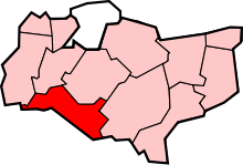
Hawkenbury is located within the Park ward of Tunbridge Wells, and elects three councillors to Tunbridge Wells Borough Council. Hawkenbury is not part of a parish council (the Borough Council acts as the Parish). Hawkenbury falls under the Tunbridge Wells South district at county level. Hawkenbury is part of the constituency of Tunbridge Wells at a national level, and South East England at a European level.[3]
Transport
The closest railway station is Tunbridge Wells. Buses serve Hawkenbury from Monday to Saturday, and are provided by Nu-Venture.
Parks and open spaces
Farmcombe Road Open Space is a small open green area. Camden Park contains a pastoral area, known as The Meadow, in the middle of an estate developed by Lord Camden in the mid-19th century.[4] The Hawkenbury Recreation Ground is a large public space that has cricket and football pitches, tennis courts, an all-weather pitch and a children's play area.
There are also allotments in Hawkenbury, in Halls Hole Road, managed by the Hawkenbury Allotment Holder's Association.
References
- ↑ "Important developments". HM Land Registry. 2011-06-01. Retrieved 2011-07-26.
- ↑ Eeles, Henry S. (1947). Frant - A Parish History. Tunbridge Wells: Courier Co., Ltd. p. 219.
- ↑ "Park". Tunbridge Wells Borough Council. Retrieved 2009-06-17.
- ↑ "Camden Park Area" (PDF). Royal Tunbridge Wells and Rusthall Conservation Areas Appraisal. Tunbridge Wells Borough Council. November 2000. Retrieved 2009-06-17.