Lake Zürich right-bank railway line
| Lake Zurich right-bank railway | ||||||||||||||||||||||||||||||||||||||||||||||||||||||||||||||||||||||||||||||||||||||||||||||||||||||||||||||||||||||||||||||||||||||||||||||||||||||||||||||||||||||||||||||||||||||||||||||||||||||||||||||||||||||||||||||||||||||||||||||||||||||
|---|---|---|---|---|---|---|---|---|---|---|---|---|---|---|---|---|---|---|---|---|---|---|---|---|---|---|---|---|---|---|---|---|---|---|---|---|---|---|---|---|---|---|---|---|---|---|---|---|---|---|---|---|---|---|---|---|---|---|---|---|---|---|---|---|---|---|---|---|---|---|---|---|---|---|---|---|---|---|---|---|---|---|---|---|---|---|---|---|---|---|---|---|---|---|---|---|---|---|---|---|---|---|---|---|---|---|---|---|---|---|---|---|---|---|---|---|---|---|---|---|---|---|---|---|---|---|---|---|---|---|---|---|---|---|---|---|---|---|---|---|---|---|---|---|---|---|---|---|---|---|---|---|---|---|---|---|---|---|---|---|---|---|---|---|---|---|---|---|---|---|---|---|---|---|---|---|---|---|---|---|---|---|---|---|---|---|---|---|---|---|---|---|---|---|---|---|---|---|---|---|---|---|---|---|---|---|---|---|---|---|---|---|---|---|---|---|---|---|---|---|---|---|---|---|---|---|---|---|---|---|---|---|---|---|---|---|---|---|---|---|---|---|---|---|---|---|
 The right-bank line at Tiefenbrunnen | ||||||||||||||||||||||||||||||||||||||||||||||||||||||||||||||||||||||||||||||||||||||||||||||||||||||||||||||||||||||||||||||||||||||||||||||||||||||||||||||||||||||||||||||||||||||||||||||||||||||||||||||||||||||||||||||||||||||||||||||||||||||
| Line length: | 31.90 kilometres (19.82 mi) | |||||||||||||||||||||||||||||||||||||||||||||||||||||||||||||||||||||||||||||||||||||||||||||||||||||||||||||||||||||||||||||||||||||||||||||||||||||||||||||||||||||||||||||||||||||||||||||||||||||||||||||||||||||||||||||||||||||||||||||||||||||
| Track gauge: | 1435 | |||||||||||||||||||||||||||||||||||||||||||||||||||||||||||||||||||||||||||||||||||||||||||||||||||||||||||||||||||||||||||||||||||||||||||||||||||||||||||||||||||||||||||||||||||||||||||||||||||||||||||||||||||||||||||||||||||||||||||||||||||||
| Voltage: | 15 kV 16.7 Hz AC | |||||||||||||||||||||||||||||||||||||||||||||||||||||||||||||||||||||||||||||||||||||||||||||||||||||||||||||||||||||||||||||||||||||||||||||||||||||||||||||||||||||||||||||||||||||||||||||||||||||||||||||||||||||||||||||||||||||||||||||||||||||
| Electrification: | Overhead line | |||||||||||||||||||||||||||||||||||||||||||||||||||||||||||||||||||||||||||||||||||||||||||||||||||||||||||||||||||||||||||||||||||||||||||||||||||||||||||||||||||||||||||||||||||||||||||||||||||||||||||||||||||||||||||||||||||||||||||||||||||||
| Maximum incline: | 1.7 % | |||||||||||||||||||||||||||||||||||||||||||||||||||||||||||||||||||||||||||||||||||||||||||||||||||||||||||||||||||||||||||||||||||||||||||||||||||||||||||||||||||||||||||||||||||||||||||||||||||||||||||||||||||||||||||||||||||||||||||||||||||||
| Zurich–Meilen–Rapperswil | ||||||||||||||||||||||||||||||||||||||||||||||||||||||||||||||||||||||||||||||||||||||||||||||||||||||||||||||||||||||||||||||||||||||||||||||||||||||||||||||||||||||||||||||||||||||||||||||||||||||||||||||||||||||||||||||||||||||||||||||||||||||
Legend
| ||||||||||||||||||||||||||||||||||||||||||||||||||||||||||||||||||||||||||||||||||||||||||||||||||||||||||||||||||||||||||||||||||||||||||||||||||||||||||||||||||||||||||||||||||||||||||||||||||||||||||||||||||||||||||||||||||||||||||||||||||||||
The Lake Zurich right-bank railway line, or Rechtsufrige Zürichseebahn, is a railway line in the Swiss canton of Zurich. As its name suggests, it runs down the right, or east, bank of Lake Zurich, connecting Zurich to Rapperswil.[1]
The line was opened in 1894, nineteen years after the complementary left bank railway. As built, it originally departed from the surface level of Zurich Hauptbahnhof station in a westerly direction, before performing a clockwise 270 degrees turn via a viaduct over the River Limmat and the Letten Tunnel to Stadelhofen station. Since 1990 the Letten Tunnel has been closed and replaced by the Hirschengraben Tunnel, which takes a direct easterly route under the River Limmat from new low level platforms at Hauptbahnhof.[1]
At the same time as the Hirschengraben tunnel was constructed, the Zürichberg tunnel was constructed in order to link Stadelhofen station with the Zurich to Winterthur and Wallisellen to Rapperswil via Uster lines. As a consequence the section of the right bank line between Zurich Hbf and Stadelhofen is now part of the backbone of the Zurich S-Bahn, carrying no fewer than eight separate routes.[1][2]
However beyond Stadelhofen the traffic reduces to three S-Bahn routes. Routes S6 and S16 stop at all stations as far as Uetikon or Meilen respectively. Route S7 runs non-stop from Stadelhofen as far as Meilen, then serves all stations to Rapperswil.[2]
The line is 31.90 kilometres (19.82 mi) long, standard gauge and electrified at 15 kV 16 2⁄3 Hz AC supplied by overhead line. It is predominantly double-track, but with single-track sections from Stadelhofen to Tiefenbrunnen, Herrliberg-Feldmeilen to Meilen, Uetikon to Stäfa, and Uerikon to Rapperswil.[1]
References
| Settlements | 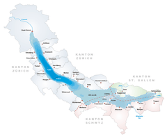  | |
|---|---|---|
| Islands | ||
| Rivers | ||
| Valleys | ||
| Mountains | ||
| Landmarks | ||
| Transportation |
| |
| People | ||