Jona
| Jona | ||
|---|---|---|
| Former municipality of Switzerland | ||
|
Jona in November 2010 | ||
| ||
 Jona | ||
|
Location of Jona 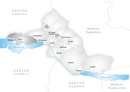 | ||
| Coordinates: 47°13′N 8°49′E / 47.217°N 8.817°ECoordinates: 47°13′N 8°49′E / 47.217°N 8.817°E | ||
| Country | Switzerland | |
| Canton | St. Gallen | |
| District | See-Gaster | |
| Municipality | Rapperswil-Jona | |
| Area | ||
| • Total | 20.43 km2 (7.89 sq mi) | |
| Elevation | 409 m (1,342 ft) | |
| Population | ||
| • Total | 17,799 | |
| • Density | 870/km2 (2,300/sq mi) | |
| Postal code | 8645 | |
| SFOS number | 3335 | |
| Localities | Bollingen, Busskirch, Curtiberg, Kempraten-Lenggis, Wagen, Wurmsbach | |
| Surrounded by | Altendorf (SZ), Bubikon (ZH), Eschenbach, Freienbach (SZ), Hombrechtikon (ZH), Kempraten, Lachen (SZ), Rapperswil, Rüti (ZH), Schmerikon, Tuggen (SZ), Wangen (SZ) | |
| Website |
www SFSO statistics | |
_-_Kempraten-Lenggis_-_R%C3%BCssel_IMG_4954.JPG)

_-_Strandbad_Stampf_IMG_1926.JPG)
_-_Busskirch_St_Martin_IMG_1941_ShiftN.jpg)
Jona is a former municipality in the Wahlkreis (constituency) of See-Gaster in the canton of St. Gallen in Switzerland.
Geography
Jona is located at the eastern shore of Obersee. It has been part of the municipality of Rapperswil-Jona since 2007, as before comprising the villages of Bollingen, Busskirch, Curtiberg, Kempraten-Lenggis, Wagen and Wurmsbach (Wurmsbach Abbey).
History
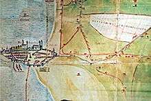
_-_Jona_IMG_1802.jpg)
The river Jona flows through the municipality in the Lake Zürich, the settlement is named after the river, first recorded in Latinized form Johanna in AD 834, as super Johannam fluvium. The Middle High German form Jonun is recorded 1243.[1] The river name was likely adapted into Alemannic (Old High German) around the 8th century from a Gallo-Roman *Jauna as a weakly inflecting feminine *Jōna(n), yielding modern dialectal Jōne(n).
In 1350, Rapperswil and its castle was widely destroyed by Rudolf Brun, and the Herrschaft Rapperswil – Rapperswil and some surrounding villages including Jona – was acquired by the Habsburg family.
After 1803's Act of Mediation, Rapperswil and Jona joined the canton of St. Gallen, and the former Herrschaft Rapperswil was split into the municipalities Rapperswil and Jona. Jona, as municipality, was established in 1803 around the former boundaries of the city of Rapperswil, comprising the small rest of the former Herrschaft Rapperswil and the villages of Bollingen, Busskirch, Curtiberg, Kempraten-Lenggis, Wagen and Wurmsbach.
In the early 19th century, Jona river's hydropower was used for a larger number of watermills along the small river. As a renewable source, the river was important for industrialization of the rapidly growing village.
On January 1, 2007, the municipalities of Rapperswil and Jona merged to form a new political entity: Rapperswil-Jona has a population of 25,777 (December 2007). This makes it the second largest town in the canton after the capital St. Gallen itself.
Transportation

Jona railway station is a stop of the Zürich S-Bahn on the lines S5 and S15. Its train station is a 33-minute (S5) ride from Zürich Hauptbahnhof.
The town's bus service has been provided, since 2008, by the Verkehrsbetriebe Zürichsee und Oberland (VZO).[2] Jona railway station area will be newly constructed by probably the end 2015, as well as the bus station situated nearby.
Personalities
- Carl Gustav Jung (1875-1961)
- Jakob Braendlin-Näf (1775-1845)
- Johann Jakob Staub (1783-1852)
- Wangpo Tethong (born 1963), Swiss-Tibetan activist, writer, spokesperson of Greenpeace Switzerland and member of the 15th Tibetan Parliament in Exile.[3]
- Alberich Zwyssig (1808-1854)
Notes
- ↑ Alois Stadler: Jona in German, French and Italian in the online Historical Dictionary of Switzerland, 2008.; Daniel Gut, Lunnern. Londons Zwilling im Reusstal: Eine sprach- und kulturgeschichtliche Verortung von Siedlungsnamen (2013), S. 48.
- ↑ "Marktgebiet" [Market area] (in German). VZO. Retrieved 2013-10-02.
- ↑ Phuntsok Yangchen (2010-11-24). "European Chitue Candidates". tibetanpoliticalreview.org. Retrieved 2015-11-30.
Literature
- Eugen Halter: Geschichte der Gemeinde Jona. Politische Gemeinde Jona, Schweizer Verlagshaus, Zürich 1970.
External links
| Wikimedia Commons has media related to Jona. |
- Rapperswil-Jona (official site) (German)
- Bollingen in German, French and Italian in the online Historical Dictionary of Switzerland.
- Busskirch in German, French and Italian in the online Historical Dictionary of Switzerland.
- Jona in German, French and Italian in the online Historical Dictionary of Switzerland.
- Kempraten in German, French and Italian in the online Historical Dictionary of Switzerland.
| Settlements | 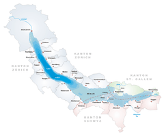 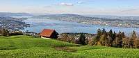 | |
|---|---|---|
| Islands | ||
| Rivers | ||
| Valleys | ||
| Mountains | ||
| Landmarks | ||
| Transportation |
| |
| People | ||