Lake Welch Parkway
| |
|---|---|
|
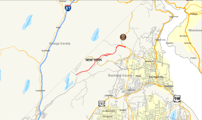
Map of Rockland County in southeastern New York with Lake Welch Parkway highlighted in red | |
| Route information | |
| Maintained by NYSDOT | |
| Length: | 5.60 mi[1] (9.01 km) |
| Existed: | June 27, 1971[2] – present |
| Major junctions | |
| South end: |
|
| North end: |
|
| Location | |
| Counties: | Rockland |
| Highway system | |

Lake Welch Parkway, sometimes labeled Lake Welch Drive, is a scenic road located within Harriman State Park in southern New York in the United States. It extends for 5.60 miles (9.01 km) on a southwest–northeast alignment from an intersection with Seven Lakes Drive to a partial interchange with the Palisades Interstate Parkway. The highway is located entirely in Rockland County, although it runs close to the border with Orange County. It is inventoried by the New York State Department of Transportation as New York State Route 987A (NY 987A), an unsigned reference route;[1] however, it is owned by the Palisades Interstate Park Commission.[3] The portion of Lake Welch Parkway that lies south of Tiorati Brook Road is closed during the winter.
Route description

Lake Welch Parkway begins, heading north, on the northbound side of Seven Lakes Drive. Although there is no direct connection with southbound Seven Lakes Drive, the section containing the interchange is widened to form a modified traffic circle, allowing U-turns on either side of this divider to permit access from both sides.
The next intersection north is with Johnsontown Road,[4] a dirt road which parallels Lake Welch Parkway, and used to run uninterrupted to Lake Welch, partially along the current parkway's right of way. It is now interrupted after ¾ mile at Camp Wikaki Rd, a non-public road for camp activities, at the next intersection with Lake Welch Parkway. A ½ mile later, the parkway intersects with the next portion of Johnsontown Rd, which is paved;[5] at the same point, the Long Path then crosses the parkway on its way up Nat House Mountain.[6][7] There is a bridge ⅔ mile later over County Route 106[4] (CR-106, Gate Hill Road and Kanawauke Rd, formerly NY 210,[8]). There is no interchange between the Parkway and CR-106, but the paved portion of Johnsontown Road provides access to CR-106, Lake Welch, and St. John's-in-the-Wilderness Church.
About 1 mile (1.6 km) northeast of the bridge, the parkway becomes divides, forming a traffic circle with the access road to the Lake Welch recreation area (lake, beach, and Beaver Pond Campground). The access road continues south to CR-106, forming another path between the two roads.[9] Lake Welch Parkway continues as a two-lane undivided road for another mile to the vicinity of Tiorati Brook Road, where it widens into a divided highway once again. The parkway connects to the road by way of a Y-interchange with a northbound-to-southbound U-turn. North of Tiorati Brook Road (also known as Cedar Pond Road), the parkway is only open seasonally.
The median ends just east of the interchange with the Palisades Interstate Parkway (exit 16 of the Palisades). The first connection encountered of this interchange is the Palisades southbound exit ramp, which merges into Lake Welch Parkway southbound. This is followed by ramps to the Palisades southbound and from the Palisades northbound, where Lake Welch Parkway ends. It is only a partial interchange, lacking a connection between Lake Welch Parkway northbound and Palisades Interstate Parkway northbound.[4] TO access the Palisades northbound requires a 3-mile detour via Gate Hill Road.
History
Lake Welch Parkway was conceived in the early 1960s as a new 2.19-mile (3.52 km) long roadway through Harriman State Park. The new 24 feet (7.3 m) wide road would connect Lake Welch Beach (which opened in 1962[10]) to the Palisades Interstate Parkway via Tiorati Brook Road. The new roadway would be constructed by the Palisades Interstate Park Commission with a 292 feet (89 m) bridge over Tiorati Creek and two other smaller bridges along the right-of-way. The new parkway would temporarily terminate at Lake Welch Beach, where an extension down to Seven Lakes Drive would be constructed. Engineers estimated the first section of the Lake Welch Parkway to cost $4.13 million (1962 USD) to build, and contracts would be let in Albany on November 16, 1962.[11]
Construction of the second segment between Seven Lakes Drive and Lake Welch Beach was announced in November 1967 with the letting of a contract to County Asphalt Incorporated, a firm based in Tarrytown. The contract was for $2,275,744 (1967 USD) and would construct the final 3.43 miles (5.52 km) miles of Lake Welch Parkway. The firm won the contract as the lowest of four bidders. The extension would also be 24 feet (7.3 m) wide beginning at the Sebago Circle along Seven Lakes Drive. In addition to the new right-of-way, an additional 0.84 miles (1.35 km) of right-of-way would be use to access the extension with Lake Welch Beach. Also included a project was a bridge over then-NY 210 (now CR 106). The slated completion date of the project was December 3, 1969 and would be supervised by the New York State Department of Transportation and its engineer out of Poughkeepsie.[12]
Construction was completed nearly four years later, with the new Lake Welch Parkway opening to traffic on June 27, 1971, a little more than 9 years after the opening of Lake Welch Beach.[10] The new parkway, 5.75 miles (9.25 km) long, intended to relieve congestion along NY 210 in access to Lake Welch Beach, and would connect to the Palisades Interstate Parkway at exit 14A (current exit 16).[2]
Major intersections
The entire route is in Harriman State Park, Rockland County.
| mi[1][2][4] | km | Destinations | Notes | ||
|---|---|---|---|---|---|
| 0.00 | 0.00 | Modified traffic circle | |||
| 3.40 | 5.47 | Interchange; access via St. Johns Road | |||
| 5.10 | 8.21 | Interchange; eastern terminus of Tiorati Brook Road | |||
| 5.60 | 9.01 | Exit 16 (Palisades Parkway) | |||
| 1.000 mi = 1.609 km; 1.000 km = 0.621 mi | |||||
See also
.svg.png) New York Roads portal
New York Roads portal
References
- 1 2 3 "2011 Traffic Volume Report for New York State" (PDF). New York State Department of Transportation. September 25, 2012. pp. 50–57. Retrieved June 11, 2013.
- 1 2 3 "Parkway Now Open". The Evening News. Newburgh, NY. June 28, 1971. p. 1B. Retrieved March 29, 2013.
- ↑ New York State Department of Transportation (January 2012). Official Description of Highway Touring Routes, Bicycling Touring Routes, Scenic Byways, & Commemorative/Memorial Designations in New York State (PDF). Retrieved June 11, 2013.
- 1 2 3 4 Google (March 31, 2011). "overview map of Lake Welch Parkway" (Map). Google Maps. Google. Retrieved March 31, 2011.
- ↑ Thiells Quadrangle – New York (Map). 1:24,000. 7.5 Minute Series (Topographic). United States Geological Survey. 1955. Retrieved March 31, 2011.
- ↑ ACME Mapper 2.0 - Overview map of Lake Welch (Map). Cartography by Mapnik. Retrieved June 11, 2013.
- ↑ "Waymarked Trails - Hiking". hiking.waymarkedtrails.org. Retrieved 2015-10-11.
- ↑ New York (Map). Cartography by General Drafting. Exxon. 1979.
- ↑ Lake Welch Site Map (New York State Department of Parks, Recreation and Historic Preservation)
- 1 2 Folsom, Merrill (June 16, 1962). "New State Beach Gets a Wet Start". The New York Times. p. 16.
- ↑ "Bids Sought For Roadwork in Rockland". The Evening News. Newburgh, NY. October 13, 1962. p. 13. Retrieved June 11, 2013.
- ↑ "Lake Welch Parkway Work Due". The Evening News. Newburgh, NY. November 15, 1967. p. 3B. Retrieved March 29, 2013.
External links
| Wikimedia Commons has media related to Lake Welch Parkway. |