Palisades Interstate Parkway


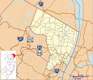
The Palisades Interstate Parkway (PIP) is a 38.25-mile-long (61.56 km) limited-access highway in the U.S. states of New Jersey and New York. The parkway is a major commuter route into New York City from Rockland and Orange counties in New York and Bergen County in New Jersey. The southern terminus of the route is at the George Washington Bridge in Fort Lee, New Jersey, where it connects to Interstate 95 (I-95), U.S. Route 1–9 (US 1–9), US 46 and Route 4. Its northern terminus is at a traffic circle in Fort Montgomery, New York, where the PIP meets US 9W and US 202 at the Bear Mountain Bridge. At exit 18, the PIP forms a concurrency with US 6 for the remaining duration of its run.
The route is named for the New Jersey Palisades, a line of cliffs rising along the western side of the Hudson River. The PIP is designated, but not signed as Route 445 in New Jersey and New York State Route 987C (NY 987C), an unsigned reference route, in New York. As with most parkways in the New York metropolitan area, commercial traffic is prohibited from using the PIP. The Palisades Interstate Parkway was built from 1947–1958, and fully opened to traffic on August 28, 1958.
Route description

The main line of the parkway is designated as Route 445 in New Jersey and NY 987C in New York. The latter is one of New York's reference routes.[1][2] A 0.42-mile (0.68 km) spur connecting the parkway to US 9W in Fort Lee, New Jersey, is designated Route 445S.[9] All three designations are unsigned and used only for inventory purposes. The parkway is owned and maintained by the Palisades Interstate Park Commission but occasional maintenance is performed by the New Jersey and New York state departments of transportation.[10][11] Commercial vehicles are prohibited on the entire length of the Palisades Interstate Parkway.[4][5]
New Jersey
The Palisades Interstate Parkway begins at the George Washington Bridge (GWB) in Fort Lee, New Jersey. Passengers from the upper level of the GWB can directly get on the PIP northbound, while passengers from the lower level of the bridge must travel through GWB Plaza on US 9W before getting on the parkway. Passengers riding northbound on the New Jersey Turnpike (I-95) must be in local lanes to directly get on the PIP. Once the PIP leaves the GWB, it proceeds north along the New Jersey Palisades, past the Englewood Cliffs Service Area. Unlike service areas further north along the parkway, there are two in Englewood, one for northbound drivers and one for southbound drivers. The others are in the center median shared by drivers going in both directions. There are also three different scenic lookout points over the Palisades near the northern tip of the island of Manhattan at the Harlem River. After this, the PIP parallels US 9W and the Hudson River for its entire run in New Jersey. All four exits in New Jersey are either with US 9W, or within mere feet of the route. The PIP leaves New Jersey into New York in the borough of Rockleigh.[12]

The entire New Jersey portion of the Palisades Interstate Parkway is within Bergen County. It is designated as a state scenic byway known as the Palisades Scenic Byway.[13] The PIP and the New Jersey Turnpike are the only highways that use sequential exit numbering in New Jersey; all others in the state are based on mileage, except for the Atlantic City–Brigantine Connector in Atlantic City, which uses lettered exits (no numerals).
New York
Rockland County
The Palisades enters Rockland County in the hamlet of Palisades. At about the border the PIP changes direction from due north along the Hudson River to a north-west direction. Shortly after the Kings Ferry Service Area in the center median, the first two exits in New York are key exits for two colleges in Rockland County. Exit 5 provides a link to St. Thomas Aquinas College, and exit 6 provides a link to Dominican College. In West Nyack, the PIP has a key interchange with the New York State Thruway (I-87 and I-287). This intersection is about seven miles (11 km) west of the Tappan Zee Bridge. After the PIP's interchange with the NY Thruway, the PIP turns slightly north-east and its speed limit increases to 55 miles per hour (89 km/h). From the GWB to the NY Thruway it is exclusively 50 miles per hour (80 km/h). At exit 13, the PIP intersects US 202 as the route crosses south of Harriman State Park in Mount Ivy. This is the first of two meetings between the PIP and US 202. At exit 15, the PIP has its last busy intersection in Rockland County with County Route 106 (CR 106, formerly part of NY 210) in Stony Point. From here, the PIP enters Harriman State Park, and at exit 16, the PIP intersects Lake Welch Parkway, which is one of several parkways commissioned within the park.[12]
Orange County
The Palisades enters Orange County north of Lake Welch Parkway at exit 16 and south of the Palisades Interstate Park Commission Visitor Center, located in the center median in what was originally a parkway service area. The first interchange in Orange County is exit 17 at Anthony Wayne Recreation Area. At exit 18, the PIP intersects US 6 and Seven Lakes Drive. US 6 west heads toward the Thruway and NY 17 five miles (8 km) west in Harriman. US 6 east forms the PIP's only concurrency for the last two miles (3 km) of the PIP's run. Seven Lakes Drive joins the two routes for one mile (1.6 km) before departing at exit 19. The two routes then enter Bear Mountain State Park in an eastern direction. Finally, the Palisades Interstate Parkway meets its end at US 9W and US 202 at a traffic circle inches from the Hudson River and the Bear Mountain Bridge. US 6 and US 202 head east over the bridge, while US 9W heads north toward the United States Military Academy in West Point.[12] (Southbound US 9W, breaking off to the right, is the same road as westbound US 202.)
History

In 1933–34, the first thoughts of a Palisades Interstate Parkway were developed by engineer and environmentalist William A. Welch, who was general manager and chief engineer of the Palisades Interstate Park Commission.[14] The plan was to build a parkway to connect the New Jersey Palisades with the state parks along the Hudson River in Rockland and Orange counties. Welch would soon garner the support of John D. Rockefeller, who donated 700 acres (2.8 km2) of land along the New Jersey Palisades overlooking the Hudson River in 1933.[15] With this favorable momentum for the new route, the proposed route was accepted as a Civil Works Administration project under Franklin D. Roosevelt's New Deal coalition. However, the New Jersey Highway Commission did not support construction, so the idea of a parkway was put on hold.[15]
During the 1940s, Rockefeller renewed the push for a parkway along the New Jersey Palisades, and teamed with ultimate PIP planner, Robert Moses, to establish and design the parkway. The plan originally was to have the PIP stretch from the Garden State Parkway, along the Hudson River, to the George Washington Bridge, and then north along its present-day route ending at the Bear Mountain Bridge. This southern extension was never built, but construction began on the current PIP in New York on April 1, 1947. Construction on the New Jersey portion began about one year later.[3] Construction was delayed twice due to material shortages, but that did not stop the PIP from being opened in stages during the 1940s and 1950s. The route was completed in New Jersey in 1957, and on August 28, 1958, the final piece of the PIP was completed between exits 5 and 9 in southern Rockland County.[3]
The PIP is known for its stone arch overpasses throughout its route and its several scenic overlooks in New Jersey. All sorts of unique trees and flowers can be seen along the route as well. In 1998, because of all the natural and constructed beauty, the PIP was designated as a national landmark by the National Park Service.[16]
Exit list
| State | County | Location | mi [1][2] | km | Exit | Destinations | Notes |
|---|---|---|---|---|---|---|---|
| New Jersey | Bergen | Fort Lee | 0.00 | 0.00 | – | ||
| 0.18 | 0.29 | George Washington Bridge – Palisades Parkway Toll Plaza (southbound only) (Cash or E-ZPass) | |||||
| – | Hudson Terrace / Myrtle Avenue | Southbound exit and entrance | |||||
| 0.31 | 0.50 | – | Southbound exit and northbound entrance | ||||
| Englewood Cliffs | 1.89 | 3.04 | 1 | ||||
| Alpine | 7.48 | 12.04 | 2 | ||||
| 9.29 | 14.95 | 3 | |||||
| 10.34 | 16.64 | 4 | |||||
| 11.06 0.00 | 17.80 0.00 | New Jersey–New York state line | |||||
| New York | Rockland | Tappan | 2.57 | 4.14 | 5 | Signed as 5N (north) and 5S (south) | |
| Orangeburg | 3.50 | 5.63 | 6 | Signed as 6E (east) and 6W (west) | |||
| West Nyack–Nanuet line | 6.40 | 10.30 | 7 | ||||
| 7.13 | 11.47 | 8 | Signed as 8E (east) and 8W (west) | ||||
| 7.91 | 12.73 | 9 | Signed as 9E (east) and 9W (west) | ||||
| New City | 9.50 | 15.29 | 10 | ||||
| New Hempstead | 11.62 | 18.70 | 11 | ||||
| 13.30 | 21.40 | 12 | |||||
| Mount Ivy | 14.32 | 23.05 | 13 | ||||
| Stony Point | 16.71 | 26.89 | 14 | ||||
| 17.92 | 28.84 | 15 | Former NY 210; no commercial vehicles north of this point | ||||
| Harriman State Park | 19.05 | 30.66 | 16 | No northbound entrance | |||
| Orange | – | Palisades Interstate Park Commission Visitor Center | Left exit; former service area | ||||
| 23.50 | 37.82 | 17 | Anthony Wayne Recreation Area | ||||
| 24.37 | 39.22 | 18 | Southern terminus of concurrency with US 6 and S.L. Drive | ||||
| 24.57 | 39.54 | 19 | Northern terminus of concurrency with S.L. Drive | ||||
| Bear Mountain State Park | 26.77 | 43.08 | – | Bear Mountain Circle; northern terminus of concurrency with US 6 | |||
1.000 mi = 1.609 km; 1.000 km = 0.621 mi
| |||||||
Rest areas
There are some rest areas on the Palisades Interstate Parkway. However, large trucks are not allowed in these rest areas.
- Sparkill (located near Exit 5N, fuel and convenience store. Open 24 Hours. Park and Ride also available. Accessible both sides.)
- Englewood Cliffs (located past exit 1 just before the George Washington Bridge, fuel and convenience store. There are two separate rest areas on both sides. Phone service is also available.)
- Alpine Lookout (Alpine): (North side only. Located near exit 2. Parking/scenic view area only. No fuel.)
- Rockefeller Lookout (Englewood Cliffs): (North side only. Parking/scenic view area only. No fuel.)
- Bear Mountain/Tompkin's Cove (located between exits 16 and 17. Information and book store. No fuel. Accessible both sides.)
Palisades Interstate Parkway Police
The Palisades Interstate Parkway Police is a highway law enforcement agency for protecting the Palisades Interstate Parkway and to enforce state and city laws. There are two headquartered locations. One location is in Pomona, New York at New York State Police Troop F, zone 2. The other location is located in Alpine, New Jersey on Alpine Approach Road. The department consists of one chief, two lieutenants, five sergeants, and twenty seven patrol officers. There are also security guards available who were trained and hired for by the police academy. Other than patrol cars, the Palisades Interstate Parkway Police also uses police boats for marine rescue operations and a bicycle unit.
See also
 U.S. Roads portal
 New Jersey portal
.svg.png) New York Roads portal
New York Roads portal Hudson Valley portal
References
- 1 2 3 "NJ Route 445 Straight Line Diagram" (PDF). New Jersey Department of Transportation. May 2010. Retrieved February 5, 2012.
- 1 2 3 "2007 Traffic Data Report for New York State" (PDF). New York State Department of Transportation. July 25, 2008. Retrieved July 17, 2009.
- 1 2 3 Staff. "PALISADES ROUTE WILL OPEN TODAY; Officials to Mark Completion of Final Link in 42-Mile Interstate Parkway", The New York Times, August 28, 1958. Accessed April 7, 2016. "The final gap in a scenic route overlooking the Hudson River will be closed with a ceremony at noon today at Orangeburg, N. Y. "
- 1 2 "TITLE 16. DEPARTMENT OF TRANSPORTATION - CHAPTER 32. TRUCK ACCESS" (PDF). New Jersey Department of Transportation. Retrieved August 13, 2010.
- 1 2 "New York Parkway truck restriction brochure" (PDF). New York City Department of Transportation and New York State Department of Transportation. Retrieved July 31, 2012.
- ↑ "National Register of Historic Place Listings". National Park Service. August 13, 1999. Retrieved April 19, 2010.
- ↑ National Park Service (July 9, 2010). "National Register Information System". National Register of Historic Places. National Park Service.
- ↑ New Jersey and National Registers of Historic Places – Bergen County, p. 1. New Jersey Department of Environmental Protection – Historic Preservation Office, updated January 25, 2016. Accessed April 7, 2016.
- ↑ "NJ Route 445S Straight Line Diagram" (PDF). New Jersey Department of Transportation. May 2010. Retrieved February 5, 2012.
- ↑ "NJDOT to begin Palisades Parkway repaving project" (Press release). NJDOT. July 17, 2014. Retrieved July 28, 2014.
- ↑ New York State Department of Transportation (January 2012). Official Description of Highway Touring Routes, Bicycling Touring Routes, Scenic Byways, & Commemorative/Memorial Designations in New York State (PDF). Retrieved February 5, 2012.
- 1 2 3 Google (September 21, 2007). "overview map of Palisades Interstate Parkway" (Map). Google Maps. Google. Retrieved September 21, 2007.
- ↑ "Scenic Byways in New Jersey – Palisades Interstate Parkway". New Jersey Department of Transportation. Retrieved July 8, 2010.
- ↑ Palisades Scenic Byway Corridor Management Plan, Palisades Interstate Park Commission. Accessed April 7, 2016. "In 1934 Welch formally presented the map, entitled Key Map Preliminary Survey Top of Palisades and Palisades Interstate Park New Jersey Section to the PIPC. In addition to the survey, Welch and Shurtleff also prepared a paper entitled A Scenic Parkway on the Top of the Palisades within the Palisades Interstate Park, State of New Jersey. This report, subsequently referred to as Welch's 'Parkway Plan', included a suggested route for the parkway, a design concept and a strategy for accomplishing the project."
- 1 2 Ingraham, Joseph C. "THE PARKWAY'S LAST LINK; Scenic Palisades Route To Open in Entirety This Week", The New York Times, August 24, 1958. Accessed April 7, 2016. "THE piecemeal construction of the Palisades Interstate Parkway, which has been abuilding since 1947, will come to an end this week when Governor Harriman cuts a ceremonial ribbon marking completion of the forty-two-mile road from the George Washington Bridge to Bear Mountain."
- ↑ "News on the Palisades Parks". The Palisades Park Conservancy. Retrieved February 21, 2008.
Further reading
- Myles, William J. (1999). Harriman Trails, A Guide and History. New York, NY: The New York–New Jersey Trail Conference.
External links
| Wikimedia Commons has media related to Palisades Interstate Parkway. |
- Palisades Interstate Parkway at Alps' Roads • New York State Highway Termini
- Palisades Interstate Parkway
- Palisades Interstate Parkway Police
- an enlarged view of road jurisdiction at the Fort Lee approaches to the George Washington Bridge
- Google maps satellite image of the southern end of the Parkway
- Palisades Parkway (NJ 445) (Greater New York Roads)
- Palisades Parkway (NY) (Greater New York Roads)
| Topics | |
|---|---|
| Lists by states |
|
| Lists by insular areas | |
| Lists by associated states | |
| Other areas | |
| |