Harriman State Park (New York)
| Harriman State Park | |
|---|---|
|
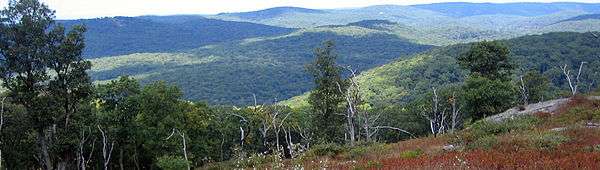
View from Harriman State Park, facing north | |
 Location of Harriman State Park in New York State | |
| Location | Orange / Rockland counties, New York, United States |
| Coordinates | 41°14′35″N 74°06′02″W / 41.24306°N 74.10056°WCoordinates: 41°14′35″N 74°06′02″W / 41.24306°N 74.10056°W |
| Area | 47,527 acres (192.33 km2)[1] |
| Established | 1910 |
| Visitors | 1,425,000 (in 2014)[1] |
| Governing body | Palisades Interstate Park Commission |
At 47,527 acres (192.33 km2),[1] Harriman State Park is the second largest state park in New York.[2] Located in Rockland and Orange counties 30 miles (48 km) north of New York City, it is a haven for hikers with over 200 miles (320 km) of hiking trails. The park is also known for its 31 lakes, multiple streams, public camping area, and great vistas. The park's hiking trails are currently maintained by volunteers from the New York - New Jersey Trail Conference.
On its northeastern edge, Harriman State Park borders the 5,000-acre (20 km2) Bear Mountain State Park as well as the United States Military Academy's 16,000-acre (65 km2) forest reserve. To the southwest, it partly borders the state-owned 18,000-acre (73 km2) Sterling Forest reserve. These areas, together with the state's Storm King forest reserve of 1,900 acres (7.7 km2), amount to contiguous protected forests that are substantially larger than Harriman alone.
History
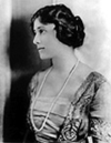
Edward Harriman and Mary Averell Harriman owned 30,000 acres (120 km2) in Arden, New York as part of their estate. They opposed the state's decision to build a prison at Bear Mountain and wanted to donate some of their land to the state in order to build a park. A year after the death of her husband in 1909, Mary Harriman proposed to Governor Charles Evans Hughes that she would donate 10,000 acres (40 km2) of land and $1 million for the creation of a new state park. As part of the deal, the state would do away with the plan to build the prison, appropriate an additional $2.5 million to acquire additional land and construct park facilities. The Palisades Interstate Park Commission would have its authority extended north into the Ramapo Mountains and the Hudson Highlands, and New Jersey would also contribute an amount of money deemed reasonable by the Commission. The state agreed and on October 29, 1910, W. Averell Harriman presented a deed for the land and a million-dollar check to the Commission.
In 1913, Major William A. Welch started construction on the road from Bear Mountain to Sloatsburg, known today as the Seven Lakes Drive. In 1962 a new road from the Southfields section of Tuxedo to Kanawake Circle was opened. There were also numerous other roads completed around Bear Mountain and Dunderberg Mountain in order to make it easier for people to reach the new park. In addition, there was steamboat service from Manhattan offering round-trip tickets for 85 cents for adults and 45 cents for children.
The park received a large influx of free labor during the Great Depression. The Civilian Conservation Corps (CCC) offered thousands of young men work such as building roads, trails, camps and lakes. Projects completed by the CCC in the park included Pine Meadow, Wanoksink, Turkey Hill, Welch, Silvermine and Massawippa Lakes. In 1993, the World Orienteering Championships were held at Harriman State Park.
Trails
There are more than forty marked hiking trails (225 miles total) in Harriman, and another 57 unmarked trails and woods road (103 miles, foot traffic only). Some of the better known trails include the following:
|
|
In addition to the hiking trails there are a number of horse trails in the southeastern portion of the park and a mountain bike trail at the Anthony Wayne Recreation Area in the northeast of the park. In winter some of the trails are open for cross-country skiing. The hiking trails are maintained by the New York - New Jersey Trail Conference.
Environment
The park lies within the Northeastern coastal forests ecoregion.[3]
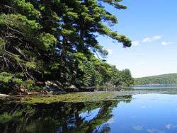
Lakes
There are 32 lakes and ponds in Harriman. Some of the larger ones are:
- Lake Sebago, 310 acres (1.3 km2), swimming beach, boat launch, cabin camping
- Lake Tiorati, 291 acres (1.18 km2), swimming beach, boat launch
- Lake Welch, 216 acres (0.87 km2), swimming beach, camping
- Lake Kanawauke (lower, middle and upper), 186 acres (0.75 km2)
- Lake Stahahe, 88 acres (360,000 m2)
- Silver Mine Lake, 84 acres (340,000 m2)
- Pine Meadow Lake, 77 acres (310,000 m2)
- Turkey Hill Lake, 58 acres (230,000 m2)
- Island Pond, 51 acres (210,000 m2)
- Lake Askoti, 41 acres (170,000 m2)
- Lake Skanatati, 38 acres (150,000 m2)
- Lake Wanoksink, 38 acres (150,000 m2)
- Lake Skenonto, 37 acres (150,000 m2)
- Queensboro Lake, 35 acres (140,000 m2)
- Hessian Lake, 33 acres (130,000 m2)
- Summit Lake, 33 acres (130,000 m2)
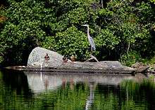
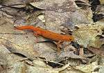 Red eft on the Suffern-Bear Mountain Trail
 Otter at Lake Sebago
 Timber rattler near the Suffern-Bear Mountain Trail
 American black duck at Lake Sebago
 Black snake on the Pine Meadow Lake Trail
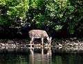
 White-tailed deer at Lake Kanawauke
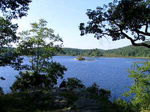 Island Pond, Harriman State Park
Shelters
There are several lean-to shelters in Harriman and Bear Mountain parks. Officially, they are the only locations in the park besides the parks designated campgrounds where overnight camping is allowed. No reservations are required for these shelters as they operate on a first-come, first-served basis. Some are listed here:
Bald Rocks, stone structure, off the Ramapo-Dunderberg Trail
Big Hill, stone structure, Suffern-Bear Mountain Trail & Long Path
Cave shelter, off the Long Path
Cohasset, metal structure, Long Path
Dutch Doctor, stone structure, off the White Bar Trail
E.D. Stone Memorial, stone structure, Suffern-Bear Mountain Trail
Fingerboard, stone structure, off the Hurst Trail
Hilltop, steel structure, off the White Bar Trail
Letterrock (Wm Brien Memorial), stone structure, Appalachian, Ramapo-Dunderberg & Menomine Trails
Stockbridge, stone structure, Long Path
Tom Jones, stone structure, off the Ramapo-Dunderberg Trail
West Mountain, stone structure with wood floor, Timp-Torne Trail, refurbished fall 2014
Parkways and park roads
The following parkways exist within the park;
- Palisades Interstate Parkway
- Seven Lakes Drive
- Long Mountain Parkway
- Lake Welch Parkway
- Tiorati Brook Road
- Arden Valley Road
- Orange-Rockland CR 106
See also
References
- 1 2 3 "Section O: Environmental Conservation and Recreation, Table O-9". 2014 New York State Statistical Yearbook (PDF). The Nelson A. Rockefeller Institute of Government. 2014. p. 672. Retrieved February 19, 2016.
- ↑ "Harriman State Park". New York State Office of Parks, Recreation and Historic Preservation. Retrieved February 19, 2016.
- ↑ Olson, D. M, E. Dinerstein; et al. (2001). "Terrestrial Ecoregions of the World: A New Map of Life on Earth". BioScience. 51 (11): 933–938. doi:10.1641/0006-3568(2001)051[0933:TEOTWA]2.0.CO;2.
- Myles, William J., Harriman Trails, A Guide and History, The New York-New Jersey Trail Conference, New York, N.Y., 1999.
- 50 Hikes in the Lower Hudson Valley
Written by New York-New Jersey Trail Conference members Stella Green and H. Neil Zimmerman - The Countryman Press. 296 pages, 2008, 2nd ed.
External links
| Wikimedia Commons has media related to Harriman State Park. |
- New York State Parks: Harriman State Park
- Palisades Interstate Park Commission: Harriman State Park
- New York-New Jersey Trail Conference: Harriman-Bear Mountain State Parks
- Harriman Hikers