Lake Eleanor
- for the Lake Eleanor in Ventura County, California, see Banning Dam
| Lake Eleanor | |
|---|---|
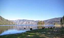 Lake Eleanor's Eastern shore in 2016, as viewed from a small peninsula | |
| Location | Yosemite National Park, Tuolumne County, California, United States |
| Coordinates | 37°58′41″N 119°52′45″W / 37.9779767°N 119.8790685°WCoordinates: 37°58′41″N 119°52′45″W / 37.9779767°N 119.8790685°W [1] |
| Type | reservoir |
| Primary inflows | Eleanor Creek |
| Basin countries | United States |
| Surface area | 953 acres (3.9 km2) |
| Water volume | 26,100 acre feet (0 km3) |
| Surface elevation | 4,657 feet (1,419 m) |
Lake Eleanor is a reservoir located in the northwestern backcountry of Yosemite National Park at an altitude of 4,657 feet (1,419 m). The reservoir has a capacity of 26,100 acre feet (32,200,000 m3) and a surface area of 953 acres (3.9 km²).
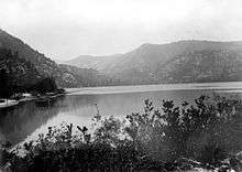
The lake was formed in 1918 by damming Eleanor Creek as part of the Hetch Hetchy Reservoir system, constructed to supply water and power to the city of San Francisco. The original smaller, natural lake was also named "Eleanor" after the daughter of Josiah Whitney, leader of the California Geological Survey in the 1860s.
Lake Eleanor Dam (National ID # CA00121) stands as a concrete multiple arch dam with a height of 68 feet (21 m) and a length of 1,260 feet (380 m). This first stage of the Hetch Hetchy project was built for year-round hydroelectric power generation, which was then sold to help finance construction of the larger O'Shaughnessy Dam, completed in 1923.[2]
That dams were planned for a valley in Yosemite National Park caused significant opposition. One of the most potent opponents was the Sierra Club and its founding President, John Muir. After two vetoes by Teddy Roosevelt, on December 19, 1913, Woodrow Wilson signed the Raker Act permitting construction. It began in 1914.
The remote location dictated the use of an unusual multiple-arch structure here. It dramatically minimized the amount of concrete used in comparison with a gravity dam. Even more unusual, the concrete arches were elliptical rather than circular, the only multiple-arch dam ever built this way.[3] Chief designer for the San Francisco Board of Public Works Michael O'Shaughnessy, along with hydraulic structural engineer R.P. McIntosh, were primarily responsible for the design.[4]
Still owned and operated by the city, the lake now provides opportunities for angling, hiking, and camping.
Climate
| Climate data for Eleanor Lake, California | |||||||||||||
|---|---|---|---|---|---|---|---|---|---|---|---|---|---|
| Month | Jan | Feb | Mar | Apr | May | Jun | Jul | Aug | Sep | Oct | Nov | Dec | Year |
| Record high °F (°C) | 75 (24) |
73 (23) |
79 (26) |
83 (28) |
87 (31) |
99 (37) |
101 (38) |
103 (39) |
98 (37) |
92 (33) |
80 (27) |
77 (25) |
103 (39) |
| Average high °F (°C) | 47.1 (8.4) |
49.1 (9.5) |
53.5 (11.9) |
59.5 (15.3) |
66.2 (19) |
75.0 (23.9) |
85.3 (29.6) |
85.4 (29.7) |
79.4 (26.3) |
68.0 (20) |
57.9 (14.4) |
49.7 (9.8) |
64.68 (18.15) |
| Daily mean °F (°C) | 36.3 (2.4) |
38.1 (3.4) |
41.7 (5.4) |
47.7 (8.7) |
54.1 (12.3) |
61.7 (16.5) |
71.0 (21.7) |
70.3 (21.3) |
64.3 (17.9) |
54.0 (12.2) |
45.2 (7.3) |
38.9 (3.8) |
51.94 (11.08) |
| Average low °F (°C) | 25.4 (−3.7) |
27.3 (−2.6) |
30.0 (−1.1) |
36.0 (2.2) |
41.9 (5.5) |
48.4 (9.1) |
56.7 (13.7) |
55.1 (12.8) |
49.1 (9.5) |
40.1 (4.5) |
32.4 (0.2) |
28.1 (−2.2) |
39.21 (3.99) |
| Record low °F (°C) | −7 (−22) |
−12 (−24) |
1 (−17) |
13 (−11) |
22 (−6) |
24 (−4) |
35 (2) |
34 (1) |
29 (−2) |
20 (−7) |
10 (−12) |
−2 (−19) |
−12 (−24) |
| Average precipitation inches (mm) | 7.71 (195.8) |
7.16 (181.9) |
5.93 (150.6) |
3.50 (88.9) |
1.91 (48.5) |
0.71 (18) |
0.09 (2.3) |
0.09 (2.3) |
0.51 (13) |
2.27 (57.7) |
4.17 (105.9) |
7.45 (189.2) |
41.5 (1,054.1) |
| Average snowfall inches (cm) | 30.3 (77) |
26.2 (66.5) |
32.2 (81.8) |
10.2 (25.9) |
1.6 (4.1) |
0.1 (0.3) |
0.0 (0) |
0.0 (0) |
0.1 (0.3) |
1.5 (3.8) |
6.7 (17) |
24.1 (61.2) |
133 (337.9) |
| Average precipitation days (≥ 0.01 in) | 10 | 10 | 10 | 8 | 7 | 3 | 1 | 1 | 2 | 5 | 6 | 9 | 72 |
| Source: Western Regional Climate Center[5][6] | |||||||||||||
See also
References
- ↑
- ↑ http://www.scahome.org/publications/proceedings/Proceedings.01Carpenter.pdf
- ↑ Building the Ultimate Dam: John S. Eastwood And the Control of Water in the West, by Donald Conrad Jackson, page 297
- ↑ Proceedings of the American Society of Civil Engineers, Volume 48, Part 1, by American Society of Civil Engineers, February, 1922
- ↑ "Lake Eleanor, California - Climate Summary - Temperature". Western Regional Climate Center. Retrieved June 21, 2012.
- ↑ "Lake Eleanor, California - Climate Summary - Precipitation". Western Regional Climate Center. Retrieved June 21, 2012.
- California Place Names, Erwin Gudde (University of California Press, 2004) ISBN 0-520-24217-3