Lac-Ashuapmushuan, Quebec
| Lac-Ashuapmushuan | |
|---|---|
| Unorganized territory | |
 | |
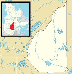 Lac-Ashuapmushuan Location in Saguenay–Lac-Saint-Jean Quebec. | |
| Coordinates: 49°10′N 73°45′W / 49.167°N 73.750°WCoordinates: 49°10′N 73°45′W / 49.167°N 73.750°W[1] | |
| Country |
|
| Province |
|
| Region | Saguenay–Lac-Saint-Jean |
| RCM | Le Domaine-du-Roy |
| Constituted | January 1, 1986 |
| Government[2] | |
| • Federal riding | Roberval—Lac-Saint-Jean |
| • Prov. riding | Roberval |
| Area[2][3] | |
| • Total | 15,704.40 km2 (6,063.50 sq mi) |
| • Land | 14,998.98 km2 (5,791.14 sq mi) |
| Population (2011)[3] | |
| • Total | 28 |
| • Density | 0.0/km2 (0/sq mi) |
| • Pop (2006–11) |
|
| • Dwellings | 1,326 |
| Time zone | EST (UTC-5) |
| • Summer (DST) | EDT (UTC-4) |
| Area code(s) | 418 and 581 |
Lac-Ashuapmushuan is an unorganized territory in the Canadian province of Quebec, located in the regional county municipality of Le Domaine-du-Roy. The region had a population of 28 as of the Canada 2011 Census, and covered a land area of 14,998.91 km2.[4] It is home to the Ashuapmushuan Wildlife Reserve.
The eponymous Lake Ashuapmushuan is roughly in the centre of the territory. This lake, about 14 kilometres (8.7 mi) long by 2.3 kilometres (1.4 mi) wide, is the source of the Ashuapmushuan River. Its name is of Innu origin, meaning "place where one lies in wait for moose".[5]
In 1685, French fur traders set up a trading post near Lake Ashuapmushuan that remained almost continuously in operation until the middle of the 19th century. It successively came under control of the Traite de Tadoussac (French period), King's Posts (English period), the North West Company (1802), and the Hudson's Bay Company (1821).[5]
Quebec Route 167 goes through the territory, but there are no services or fuel available for its entire length.
Toponymy
The Ashuapmushuan Wildlife Reserve and the unorganized territory of Lac-Ashuapmushuan take their name from the Ashuapmushuan River. This river flows into Lake Saint-Jean and was frequently traveled by fur traders at the time of the New France and also the English regime, in order to make commercial treaties, especially human trafficking fur. This river was a preferred axis to connect in canoes between Lac Saint-Jean and James Bay. This area is renowned for hunting and fishing.
Demographics
Population trend:[6]
- Population in 2011: 28 (2006 to 2011 population change: -20.0%)
- Population in 2006: 35
- Population in 2001: 0
- Population in 1996: 0
- Population in 1991: 3
Private dwellings occupied by usual residents: 15 (total dwellings: 1,326)
References
- ↑ Reference number 149740 of the Commission de toponymie du Québec (French)
- 1 2 Ministère des Affaires municipales, des Régions et de l'Occupation du territoire - Répertoire des municipalités: Lac-Ashuapmushuan
- 1 2 "Lac-Ashuapmushuan census profile". 2011 Census data. Statistics Canada. Retrieved 2010-12-06.
- ↑ "Lac-Ashuapmushuan community profile". 2006 Census data. Statistics Canada. Retrieved 2010-12-06.
- 1 2 "Rivière Ashuapmushuan" (in French). Commission de toponymie du Québec. Retrieved 2010-12-06.
- ↑ Statistics Canada: 1996, 2001, 2006, 2011 census
 |
Baie-James, Chibougamau | Rivière-Mistassini | | |
| Baie-James La Tuque |
|
Saint-Thomas-Didyme La Doré Saint-Félicien Saint-Prime Sainte-Hedwidge | ||
| ||||
| | ||||
| La Tuque | Saint-François-de-Sales Lac-Bouchette |
| Cities & Towns | |
|---|---|
| Municipalities | |
| Parishes | |
| Villages | |
| Unorganized territories | |
| |