La Grange Lock and Dam
|
La Grange Lock and Dam Historic District | |
|
Aerial view of the dam | |
  | |
| Nearest city | Versailles, Illinois |
|---|---|
| Coordinates | 39°56′27″N 90°32′02″W / 39.94083°N 90.53389°WCoordinates: 39°56′27″N 90°32′02″W / 39.94083°N 90.53389°W |
| Area | 17.6 acres (7.1 ha) |
| Built | 1939 |
| MPS | Illinois Waterway Navigation System Facilities MPS |
| NRHP Reference # | 04000170[1] |
| Added to NRHP | March 10, 2004 |
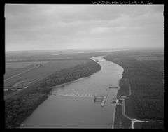
La Grange Lock and Dam is a lock and dam complex on the Illinois River at Versailles, Illinois. The structure includes a 1,066 feet (325 m) dam and a 110 by 600 feet (34 by 183 m) lock. The U.S. Army Corps of Engineers built the complex from 1936 to 1939; A.F. Griffin designed the lock and dam, while Paul Le Gromwell designed the control station. The lock and dam, as well as a similar lock and dam near Peoria, were constructed in response to a Supreme Court order limiting the amount of water which could be diverted from Lake Michigan via the river. The lock uses Chanoine wicket gates, which allow for navigation on the river, rather than the Tainter gates seen elsewhere on the river.[2][3]
The structure was added to the National Register of Historic Places on March 10, 2004.[1]
References
- 1 2 National Park Service (2010-07-09). "National Register Information System". National Register of Historic Places. National Park Service.
- ↑ "LaGrange Lock & Dam" (PDF). U.S. Army Corps of Engineers. Retrieved January 4, 2014.
- ↑ "Illinois Waterway, La Grange Lock and Dam" (PDF). Historic American Engineering Record. Retrieved January 4, 2014.
| Topics | |
|---|---|
| Lists by states |
|
| Lists by insular areas | |
| Lists by associated states | |
| Other areas | |
| |