Kicking Horse River
| Kicking Horse River | |
 Kicking Horse River | |
| Country | Canada |
|---|---|
| Province | British Columbia |
| Source | Wapta Lake |
| - location | Hector, Yoho National Park |
| Mouth | Columbia River |
| - location | Golden |
| - coordinates | 51°18′N 116°59′W / 51.300°N 116.983°WCoordinates: 51°18′N 116°59′W / 51.300°N 116.983°W |
| Discharge | for near Golden |
| - average | 40.9 m3/s (1,444 cu ft/s) [1] |
| - max | 402 m3/s (14,196 cu ft/s) |
| - min | 2.25 m3/s (79 cu ft/s) |

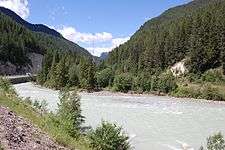
The Kicking Horse River is in the Canadian Rockies of southeastern British Columbia, Canada.[2] The river was named in 1858, when James Hector, a member of the Palliser Expedition, reported being kicked by his packhorse while exploring the river. Hector named the river and the associated pass as a result of the incident. The Kicking Horse Pass, which connects through the Rockies to the valley of the Bow River, was the route through the mountains subsequently taken by the Canadian Pacific Railway when it was constructed during the 1880s. The railway's Big Hill and associated Spiral Tunnels are in the Kicking Horse valley and were necessitated by the steep rate of descent of the river and its valley.
Kicking Horse Pedestrian Bridge in Golden is the longest authentic covered timber-frame bridge in Canada.[3] Planned as a community project by the Timber Framers Guild, local volunteers were joined by carpenters and timber framers from Canada, the United States and Europe. The bridge structure is 150 feet (46 m) long, with a 210,000-pound (95,000 kg) Burr arch structure. The bridge was completed in September 2001.
The Trans-Canada Highway traverses the river at several points from Yoho National Park to Golden, British Columbia. The river is spanned by the new Park Bridge. Kicking Horse Mountain Resort, named for the river and pass, is located not in the Canadian Rockies but across the Rocky Mountain Trench in the Dogtooth Range of the Purcell Mountains, on the other side of the town of Golden.
Course
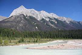
The Kicking Horse River begins at the outlet of small Wapta Lake and flows southwest. It receives the Yoho River upstream from Field. The river continues to flow southwest until after it drops over Wapta Falls, when it takes a near hairpin turn and flows northwest into the Columbia River in Golden.
Waterfalls
The river has three waterfalls along its stretch. The first is the Kicking Horse Cascade, a long talus cascade which occurs just below the first highway crossing of the river below Wapta Lake. The second is the Natural Bridge Falls near Field. The final and largest is 100-foot (30 m) Wapta Falls, one of the largest waterfalls in Canada in both volume and width. They are over 500 feet (150 m) wide.
Natural history
History

The River’s unusual name stems from an incident near Wapta Falls in August 1858, Sir James Hector writes:
“A little way above this fall one of our pack horses, to escape the fallen timber, plunged into the river, luckily where it formed an eddy, but the banks were so steep that we had great difficulty in getting him out. In attempting to recatch my own horse, which had strayed off while we were engaged with the one in the water, he kicked me in the chest, but I had luckily got close to him before he struck out, so that I did not get the full force of the blow. However, it knocked me down and rendered me senseless for some time. This was unfortunate, as we had seen no tracks of game in the neighbourhood, and were now without food; but I was so hurt that we could not proceed further that day at least.” - James Hector chronicles, 1858
James Hector
As surgeon and geologist to the Palliser Expedition from 1857 to 1860, Hector explored the country from the Red River Colony (Winnipeg) to Vancouver Island. He made many important observations regarding the geology and ethnology of the Canadian West and the Rocky Mountains, discovering the Kicking Horse Pass and giving the Kicking Horse River its name.
Recreation
Several whitewater rafting companies, as well as kayakers and canoeists, use the river. There are three main sections of the Kicking Horse River used for such recreation. The upper canyon (accessed via Beaverfoot Road off Highway 1 West) is a class 3-4 whitewater run suitable for canoes, kayaks and rafts. The middle canyon (accessed via Kicking Horse rest area) is a class 4-5 run suitable only for experienced kayakers and rafters. Commercial rafting companies avoid this section, due to the risk involved. The lower canyon is another class 4-5 whitewater run that is run by commercial rafting companies at suitable water levels. The Kicking Horse is home to many varieties of freshwater fish, making fishing a viable activity.
Major tributaries
- Sherbrooke Creek
- Yoho River
- Emerald River
- Amiskwi River
- Otterhead River
- Ottertail River
- Porcupine Creek
- Beaverfoot River
- Glenogle Creek
See also
| Wikimedia Commons has media related to Kicking Horse River. |
Notes
- ↑ "Archived Hydrometric Data Search". Water Survey of Canada. Retrieved October 19, 2008. Search for Station 08NA006 Kicking Horse River near Golden
- ↑ "Kicking Horse River". BC Geographical Names.
- ↑ "Kicking Horse Pedestrian Bridge". Tourism Golden. Retrieved 2008-08-21.
| Rivers |
|
|---|---|
| Nominated | |
| |