Red River of the North
| Red River of the North | |||||||||||||
| Rivière Rouge / Rivière Rouge du Nord | |||||||||||||
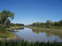
 The Red River in Fargo–Moorhead, as viewed from the Fargo side of the river | |||||||||||||
| Countries | United States, Canada | ||||||||||||
|---|---|---|---|---|---|---|---|---|---|---|---|---|---|
| Regions | Minnesota, North Dakota, Manitoba | ||||||||||||
| Part of | Nelson River basin | ||||||||||||
| Tributaries | |||||||||||||
| - left | Bois de Sioux River, Wild Rice River (North Dakota), Sheyenne River, Elm River, Turtle River, Pembina River, Assiniboine River | ||||||||||||
| - right | Otter Tail River, Buffalo River, Wild Rice River (Minnesota), Red Lake River, Roseau River, Seine River (Manitoba) | ||||||||||||
| Cities | Fargo, North Dakota, Grand Forks, North Dakota, Winnipeg, Manitoba, Selkirk, Manitoba | ||||||||||||
| Source | Confluence of Bois de Sioux and Otter Tail Rivers | ||||||||||||
| - location | Wahpeton, North Dakota | ||||||||||||
| - elevation | 948 ft (289 m) | ||||||||||||
| - coordinates | 46°15′52″N 96°35′55″W / 46.26444°N 96.59861°W | ||||||||||||
| Mouth | Lake Winnipeg | ||||||||||||
| - elevation | 712 ft (217 m) | ||||||||||||
| - coordinates | 50°23′47″N 96°48′39″W / 50.39639°N 96.81083°WCoordinates: 50°23′47″N 96°48′39″W / 50.39639°N 96.81083°W | ||||||||||||
| Length | 550 mi (885 km) | ||||||||||||
| Basin | 111,004 sq mi (287,499 km2) [1] | ||||||||||||
| Discharge | for Lockport, Manitoba, 20 miles (32 km) above the mouth | ||||||||||||
| - average | 8,617 cu ft/s (244 m3/s) | ||||||||||||
| - max | 152,900 cu ft/s (4,330 m3/s) | ||||||||||||
| - min | 491 cu ft/s (14 m3/s) | ||||||||||||
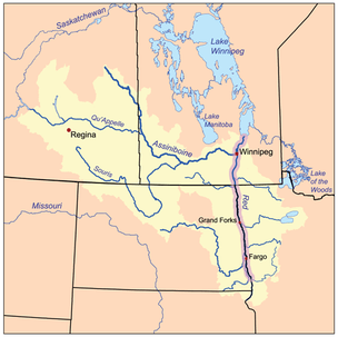 The Red River drainage basin, with the Red River highlighted
| |||||||||||||
| |||||||||||||
The Red River (French: Rivière rouge or Rivière Rouge du Nord, American English: Red River of the North) is a North American river. Originating at the confluence of the Bois de Sioux and Otter Tail rivers between the U.S. states of Minnesota and North Dakota, it flows northward through the Red River Valley, forming the border of Minnesota and North Dakota and continuing into Manitoba, Canada. It empties into Lake Winnipeg, whose waters join the Nelson River and ultimately flow into the Hudson Bay.
Several urban areas have developed on both sides of the Red River, including those of Fargo-Moorhead and Grand Forks-East Grand Forks in states of North Dakota and Minnesota, respectively, in the United States and Winnipeg in Canada. The Red is about 885 kilometres (550 mi) long,[2] of which about 635 kilometres (395 mi) are in the United States and about 255 kilometres (158 mi) are in Canada.[3] The river falls 70 metres (230 ft) on its trip to Lake Winnipeg, where it spreads into the vast deltaic wetland known as Netley Marsh.
In the United States, the Red River is sometimes called the Red River of the North. This distinguishes it from the so-called Red River of the South, a tributary of the Atchafalaya River that forms part of the border between Texas and Oklahoma.
Long a highway for trade, the Red has been designated as a Canadian Heritage River.
History
The watershed of the Red River was part of Rupert's Land, the concession established by the British Hudson's Bay Company in north central North America. The Red was a key trade route for the company, and contributed to the settlement of British North America. The river was long used by fur traders, including the French and the Métis people, who established a community in this area before the British defeated France in the Seven Years War. Following that, they took over French territory in Canada. Settlers of the Red River Colony established farming along the river, and their primary settlement developed as Winnipeg, Manitoba. What became known as the Red River Trails, nineteenth-century oxcart trails developed originally by the Métis, supported the fur trade and these settlements. They contributed to further development of the region on both sides of the international border.
Geography


The Red River forms where Wahpeton, North Dakota-Breckenridge, Minnesota, have developed. It is bordered by the twin cities of Fargo, North Dakota– Moorhead, Minnesota, and Grand Forks, North Dakota – East Grand Forks, Minnesota. It continues north to the province of Manitoba in Canada. Manitoba's capital, Winnipeg, is at the Red's confluence with the Assiniboine River, at a point referred to there as The Forks. Together with the Assiniboine, the Red River fully encloses the endorheic basin of Devils' Lake and Stump Lake.
The Red flows further north before draining into Lake Winnipeg through the Nelson River, both part of the Hudson Bay watershed. The mouth of the Red River forms a freshwater river delta called the Netley-Libau Marsh.[4] The Netley Marsh is west of the Red and the Libau Marsh is east, forming a 26,000-hectare (64,000-acre) wetland.
Southern Manitoba has a comparatively long frost-free season, between 120 and 140 days in the Red River Valley.[5]
Geology
The Red River flows across the flat lake bed of the ancient glacial Lake Agassiz, an enormous glacial lake created at the end of the Wisconsin glaciation from meltwaters of the Laurentide ice sheet. As this continental glacier decayed, its meltwaters formed the lake. Over thousands of years, sediments precipitated to the bottom of the lakebed. These lacustrine soils are the parent soils of today's Red River Valley. The river is very young; it developed only after Lake Agassiz drained, about 9,500 years ago.[6]
The word "valley" is a misnomer. While the Red River drains the region, it did not create a valley wider than a few hundred feet. The much wider floodplain is the lake bed of the ancient glacial lake.[7] It is remarkably flat; from its origin near Breckenridge, Minnesota, to the international border near Emerson, Manitoba, its gradient is only about 1:5000 (1 metre per 5 kilometres), or approximately 1 foot per mile. The river, slow and small in most seasons, does not have the energy to cut a gorge. Instead it meanders across the silty bottomlands in its progress north.[7][8] In consequence, high water has nowhere to go, except to spread across the old lakebed in "overland flooding". Heavy snows or rains, especially on saturated or frozen soil, have caused a number of catastrophic floods, which often are made worse by the fact that snowmelt starts in the warmer south, and waters flowing northward are often dammed or slowed by ice.[7][9] These periodic floods have the effect of refilling, in part, the ancient lake.[8]
Floods
Major floods in historic times include those of 1826, 1897, 1950, 1997, 2009, 2011, and there has been significant flooding many years in between.[10] Geologists have found evidence of many other floods in prehistoric times of equal or greater size. These "paleofloods" are known from their effects on local landforms, and have been the subject of scholarly studies.[11] After the disastrous 1950 flood, which resulted in extensive property damage and losses in Winnipeg, Manitoba Province undertook flood prevention by constructing the Red River Floodway. Completed in 1968, it diverts floodwaters around the city to less settled areas further up the river.
Grand Forks, North Dakota, and East Grand Forks, Minnesota, suffered widespread destruction in the flood of 1997. 75% of the population in the former city was evacuated, and all of the latter. Many of the residential areas along the rivers were inundated and all the homes had to be destroyed. Afterward a massive flood protection project was undertaken to protect both cities.
1950 flood
On May 8, 1950 the Red River reached its highest level at Winnipeg since 1861.[12] Eight dikes protecting Winnipeg gave way and flooded much of the city, turning 600 square miles (1,554 km2) of farmland into an enormous lake. The city turned to the Canadian Army and the Red Cross for help, and nearly 70,000 people were evacuated from their homes and businesses. Four of eleven bridges in the city were destroyed, and damage was estimated at between $900 million and $1 billion.
As a result of the floods, a flood control project was constructed to prevent such damage in the future. The Red River Floodway around Winnipeg attracted some derision at the time, as some people thought it was massively overbuilt and was the then-largest earth-moving project in the world. The project was completed under-budget, and has been used for at least some flood control 20 times in the 37 years from its completion to 2006. The Floodway has saved an estimated $10 billion (CAD) in flood damages.
1997 flood
In the spring of 1997 a major flood of the Red River caused a total of $3.5 billion in damage and required temporary evacuation of towns and cities on both sides of the border. The cities of Grand Forks, North Dakota, and East Grand Forks, Minnesota, suffered the most damage, and most of their populations had to be evacuated. The river crested at more than 54 feet (16 m) above datum.
The cities worked with FEMA and the state of Minnesota to clear the floodplains of the river on both sides, prohibiting future housing or businesses in this area. They created the Greater Grand Forks Greenway on both sides, which includes city and state parks, a long bike trail, and other recreational amenities. The trees and greenery help absorb floodwaters. A dike system was constructed outside this area on both sides to protect the cities from future floods. In East Grand Forks, a removable flood wall was constructed in the downtown area so that residents did not lose their connection to the river.
In Winnipeg, the flood crested at 24.5 feet (7.5 m) above datum at the James Avenue pumping station, making it the third-highest flood at Winnipeg in recorded history. It was surpassed by the floods of 1852, and 1826.[13]
2009 flood
| Wikinews has related news: Fargo, North Dakota, prepares for record flooding |
In 2009 the Red River flooded in early spring. By Friday, March 27, the river at Fargo had reached the highest level in recorded history.[14][15] Its discharge at that location was far in excess of normal flows.[16] The river crested at the James Avenue pumping station in Winnipeg at 22.5 feet (6.9 m) above datum, making it the fourth-highest flood in recorded history.[13]
2011 flood
Due to a wet summer in 2010, as well as an above average amount of snowfall through the winter in the Red River Valley, the Red River spilled its banks. It crested in Winnipeg at the James Avenue pumping station at 19.59 feet (5.97 m) above datum, as the sixth highest flood levels in recorded history if flood protection such as the Portage Diversion and the Red River Floodway were not in place.[17] That same year there was a surprise major flood on the Assiniboine River. In May 2011, a Manitoba-wide state of emergency was declared in the wake of a 300-year flood on the Assiniboine River at Brandon. Many residents had to be evacuated.[18][19][20]
Flow rates and flood potential
Below are the estimated, measured, and calculated peak flow rates of the Red River at various locations for the top ten floods of the Red River Valley, as measured at Winnipeg.
| Location | 1826 Peak Flow (cfs) | 1852 Peak Flow (cfs) | 1997 Peak Flow (cfs) | 2009 Peak Flow (cfs) | 1861 Peak Flow (cfs) | 2011 Peak Flow (cfs) | 1950 Peak Flow (cfs) | 1979 Peak Flow (cfs) | 1996 Peak Flow (cfs) | 2006 Peak Flow (cfs) |
|---|---|---|---|---|---|---|---|---|---|---|
| Wahpeton-Breckenridge[21] | - | - | 12,800 | 15,400 | - | 10,240 | - | 7,050 | - | 10,720 |
| Fargo-Moorhead[21] | - | - | 28,000 | 29,500 | - | 26,200 | - | 17,300 | - | 19,900 |
| Grand Forks-East Grand Forks[21][22] | 135,000 | 95,000 | 114,000 | 76,700 | 65,000 | 86,100 | 54,000 | 82,000 | 58,100 | 72,800 |
| Emerson/Pembina[21][22] | 151,000 | - | 133,000 | 87,900 | - | 84,700 | 95,500 | 92,700 | 66,700 | 73,500 |
| Winnipeg[23] | 225,000 | 165,000 | 163,000 | 128,000 | 125,000 | 116,000 | 108,000 | 108,000 | 108,000 | 99,000 |
See also
- List of rivers of Manitoba
- List of longest rivers of Canada
- List of longest rivers of the United States (by main stem)
- List of rivers of the United States
- Red River (disambiguation), other rivers with the same name
Notes
- ↑ Atlas of Canada. "Rivers of Canada". Retrieved 2008-08-02.
- ↑ Red River of the North, Minnesota Department of Natural Resources
- ↑ Red River Map 3, Minnesota DNR; map shows the international border at river mile 155.
- ↑ http://www.gov.mb.ca/waterstewardship/water_quality/state_lk_winnipeg_report/pdf/state_of_lake_winnipeg_rpt_technical_high_resolution.pdf
- ↑ Microsoft Encarta 2005. Retrieved on October 18, 2008.
- ↑ Schwert, Don (interviewed by Tom Crann), "The geology of the Red River flood plain", Minnesota Public Radio, 25 March 2005. Taped interview.
- 1 2 3 Schwert, Donald P. "A Brief Overview of the Geology of the Fargo – Moorhead Region, North Dakota – Minnesota". Fargo Geology. North Dakota State University.
- 1 2 Meryhew, Richard (March 24, 2009). "Geology set the Red River on a course for flooding". Minneapolis Star-Tribune. p. 1.
- ↑ Puxley, Chinta (27 March 2009). "Manitoba flood forecasters say don't be alarmed by flooding in Dakota". Yahoo! News Canada.
- ↑ Major Historical Floods in the Red River Basin
- ↑ "Paleofloods in the Red River Basin"
- ↑ "Winnipeg Flood – 1950". SOS! Canadian Disasters: Water. Library and Archives Canada. 14 February 2006.
- 1 2 "An Overview of 2009 Spring Flooding in Manitoba" (PDF). Province of Manitoba. August 2009.
- ↑ Gunderson, Dan; Robertson, Tom; Nelson, Tim (2009-03-27). "Red River tops historic marker, undermines dike". Minnesota Public Radio. Retrieved 2009-03-27.
- ↑ Kolpack, Dave (March 28, 2009). "Red River valley gets good news in new flood forecast". Minnesota Public Radio. (AP)
- ↑ "Real-Time Water Data for Red River of the North at Fargo, ND". National Water Information System: Web Interface. United States Geological Survey. 27 March 2009.
- ↑ "The Red River reached an open water crest in Winnipeg at James Avenue yesterday at 19.59 feet". Manitoba Floods. 6 May 2011.
- ↑ "Evacuees wait to return home as Brandon faces one-in-300-year flood". CTV news. Retrieved 2012-09-03.
- ↑ "Title unknown". The Canadian Press. Retrieved 2012-09-03.
- ↑ "Title unknown". CJOB 68. Archived from the original on March 31, 2012. Retrieved 2012-09-03.
- 1 2 3 4 "Long Term Flood Solutions For the Red River Basin" (PDF). Red River Basin Commission. September 2011.
- 1 2 "Long Term Flood Solutions For the Red River Basin Appendix B" (PDF). Red River Basin Commission. September 30, 2011.
- ↑ "Flood Fighting in Manitoba". Province of Manitoba. 2013.
External links
| Wikimedia Commons has media related to Red River of the North. |
- Flows and forecasts for the Red River.
- Geological Survey of Canada page describing the nature and history of Red River floods.
- Minnesota DNR Red River website
- U.S. Geological Survey Reports and Abstracts Related to the Red River of the North
- Water Quality in the Red River of the North
- Flood management in the Red River Basin
- Fish of the Red River–Red River Angler's Guide
- North Dakota State University's Fargo Flood website
- Steamboats on the Red Documentary produced by Prairie Public Television
- Red River stream gage map with touch-friendly interface
| Rivers |
|
|---|---|
| Nominated | |
| |