Kesälahti
| Kesälahti | ||
|---|---|---|
| Former municipality | ||
| Kesälahden kunta | ||
| ||
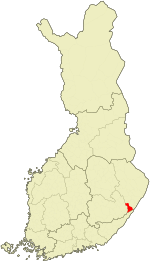 Location of Kesälahti in Finland | ||
| Coordinates: 61°53.5′N 029°50′E / 61.8917°N 29.833°ECoordinates: 61°53.5′N 029°50′E / 61.8917°N 29.833°E | ||
| Country | Finland | |
| Region | North Karelia | |
| Sub-region | Central Karelia sub-region | |
| Charter | 1873 | |
| Government | ||
| • Municipal manager | Jorma Turunen | |
| Area[1] | ||
| • Total | 583.08 km2 (225.13 sq mi) | |
| • Land | 387.89 km2 (149.77 sq mi) | |
| • Water | 195.19 km2 (75.36 sq mi) | |
| Population (2012)[2] | ||
| • Total | 2,326 | |
| • Density | 6/km2 (20/sq mi) | |
| Time zone | EET (UTC+2) | |
| • Summer (DST) | EEST (UTC+3) | |
| Website | www.kesalahti.fi | |
Kesälahti is a former municipality of Finland. It was consolidated with Kitee on 1 January 2013.
It is located in the province of Eastern Finland and is part of the North Karelia region. The municipality has a population of 2,326 (31 December 2012)[2] and covers an area of 583.08 square kilometres (225.13 sq mi) of which 195.19 km2 (75.36 sq mi) is water.[1] The population density is 5.9965/km2 (15.531/sq mi).
The municipality was unilingually Finnish. The municipality has previously also been known as "Kesälax" in Swedish documents, but is today referred to as "Kesälahti" also in Swedish.[3]
References
- 1 2 "Area by municipality as of 1 January 2011" (PDF) (in Finnish and Swedish). Land Survey of Finland. Retrieved 9 March 2011.
- 1 2 "VÄESTÖTIETOJÄRJESTELMÄ REKISTERITILANNE 31.1.2012" (in Finnish and Swedish). Population Register Center of Finland. Retrieved 11 February 2014.
- ↑ "Population according to language and the number of foreigners and land area km2 by area as of 31 December 2008". Statistics Finland's PX-Web databases. Statistics Finland. Retrieved 29 March 2009.
External links
![]() Media related to Kesälahti at Wikimedia Commons
Media related to Kesälahti at Wikimedia Commons
- Municipality of Kesälahti – Official website (Finnish)
| Municipalities |  | |
|---|---|---|
| Former municipalities |
| |
This article is issued from Wikipedia - version of the 4/21/2015. The text is available under the Creative Commons Attribution/Share Alike but additional terms may apply for the media files.