Keo Commercial Historic District
|
Keo Commercial Historic District | |
 | |
  | |
| Location | Main & Fleming Sts., AR 232, Keo, Arkansas |
|---|---|
| Coordinates | 34°36′2″N 92°0′33″W / 34.60056°N 92.00917°WCoordinates: 34°36′2″N 92°0′33″W / 34.60056°N 92.00917°W |
| Area | 19 acres (7.7 ha) |
| Built | 1913 |
| Architectural style | Early Commercial |
| NRHP Reference # | 11000355[1] |
| Added to NRHP | June 15, 2011 |
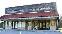
The Keo Commercial Historic District encompasses a cluster of commercial and industrial buildings that make up the economic center of the small city of Keo, Arkansas. The district includes a two-block section of Main Street, anchored at its southern end by the Cobb Cotton Gin complex, and on the north by Arkansas Highway 232, where it extends a short way in both directions. The community grew around the Cotten Belt Railroad line, which Main Street was laid out just west of. The cotton gin complex has its origins in 1906, as a means for local farmers to process their cotton and send it on to market via the railroad.[2]
The district was listed on the National Register of Historic Places in 2011.[1]
See also
References
- 1 2 National Park Service (2010-07-09). "National Register Information System". National Register of Historic Places. National Park Service.
- ↑ "NRHP nomination for Keo Commercial Historic District" (PDF). Arkansas Preservation. Retrieved 2016-01-15.
| Topics | |
|---|---|
| Lists by states |
|
| Lists by insular areas | |
| Lists by associated states | |
| Other areas | |
| |
This article is issued from Wikipedia - version of the 12/2/2016. The text is available under the Creative Commons Attribution/Share Alike but additional terms may apply for the media files.