Kennon Road
| Kennon Road | |
|---|---|
|
Benguet Road Rosario–Baguio Road | |
|
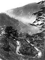
Kennon Road at Camp 3 in Tuba, Benguet | |
| Route information | |
| Length: | 41.2 km (25.6 mi) |
| Major junctions | |
| North end: | Aspiras–Palispis Highway and Governor Pack Road in Baguio |
| South end: | MacArthur Highway in Rosario |
| Location | |
| Major cities: | Baguio |
| Towns: | Rosario, Pugo, Tuba |
| Highway system | |
| Highways in the Philippines | |

Kennon Road (formerly the Benguet Road[1] and also known as the Rosario–Baguio Road) is a roadway in Benguet province in the Philippines connecting the mountain city of Baguio to the lowland towns of Rosario and Pugo in La Union province. The project was begun in 1903 and opened for travel on January 29, 1905. It was originally called the Benguet Road and later renamed in honor of its builder, Col. Lyman Walter Vere Kennon of the U.S. Army Corps of Engineers. For travelers coming from Manila or the provinces in the central plains of Luzon, it is the shortest route to Baguio.[2]
Profile

Coming from the lowlands, Kennon Road is one of the three major access roads that lead to the highland city of Baguio.[3] The upward climb reveals a picturesque view of the mountains, lush vegetation, and pine trees as one gets closer to the city.
Most of the highway's stretch encompasses the municipality of Tuba in the province of Benguet.[4] The small settlements along the road, known as Camps 1 to 8, were originally established for the pioneer builders of the road,[1] but have been occupied since by local residents. The Bued River flows along a rocky canyon from the lofty heights, and following this course the road was cut above the river bed.
The highway is a toll road,[3][5] with the lower tollgate located about 2.5 kilometres (1.6 mi) from the junction at Rosario near Camp 1. The upper tollgate is about 13 kilometres (8.1 mi) south of Baguio near the Lion's Head and Camp 6, in Tuba.
The steepest portion of the road between Camp 6 and Camp 7 in Baguio is commonly known as "Zigzag Road" because of the numerous switchbacks required. The design of the road switchbacks along that section of the road are similar in construction to the agricultural rice terraces found locally in Benguet and the other mountain provinces of the Cordillera Administrative Region.
History

The construction of the road commenced in 1903 by cutting across the mountains of Benguet with the combined efforts of Filipinos, Americans, Filipino-Chinese and Japanese nationals. It was considered one of the most difficult and expensive civil engineering projects of its day, with expenditures by the newly established Insular Government of the Philippine Islands in excess of US$2.7 million.[6]
More than 2,300 foreign and local workers worked on the road. Aside from Filipino engineers and construction workers and U.S. Army Corps of Engineers headed by Col. Lyman Kennon, foreigners from 36 countries were recruited to work on the road; the majority, about 1,500, were Japanese. Hundreds of workers died from malaria while more plunged to their deaths while building the road. After the road was completed, some of the foreign road workers decided to remain in Baguio to live permanently.[2]
The original road was a Macadam Telford-type road which was later improved into an all-weather asphalt roadway. More recently, some portions of Kennon Road have been replaced with concrete pavement.[7]
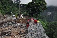
The highway was severely damaged by the 1990 Luzon earthquake[3] that the Department of Public Works and Highways decided for the permanent closure of the road.[8] The highway was proposed to be replaced by a road traversing through the town of Itogon on the way to the lowlands of San Manuel, but was met with criticism from the inhabitants of Baguio. Kennon Road was reopened for public use in September 1, 1991 after rehabilitation efforts were completed.[8]
Road hazards
Kennon Road is one of the most hazardous roads in the Philippines,[10] especially during rainy seasons, when road accidents are common. The road is closed during heavy rains or typhoon conditions to avoid casualties from landslides[10] [11] [12] [13]
Portions of the highway are also prone to land-sinking, particularly along Barangay Camp 3 in Tuba.[14]
Although Kennon is the shortest of the three major access roads, travel time is frequently as long as the other two because of poor road conditions. It usually takes an experienced commuter from 45 minutes to an hour to negotiate the 41.2-kilometre (25.6 mi) steep and winding climb by car.
Seasoned locals, race car drivers and motorsports enthusiasts, due to better road conditions, are now completing the drive under 30 to 25 minutes/ [7]
Junctions
| Location | Road[4] | Notes |
|---|---|---|
| Baguio | Governor Pack Road | Terminus |
| Ben Palispis Highway | Terminus | |
| Baguio General Hospital Elliptical Road | ||
| Military Cut Off Road | ||
| Camp 8 Road | ||
| Balsigan Road | ||
| Puliwes Road | ||
| Milo Subdivision Road | ||
| Agpaoa Street | ||
| Camp 7 West Road | ||
| Amparo Heights Road | ||
| Loakan Road | ||
| Rosario, La Union | MacArthur Highway | Terminus |
Future
When completed in 2016, the 88.5-kilometer-long Tarlac–Pangasinan–La Union Expressway will connect Kennon Road to the Subic–Clark–Tarlac Expressway[15] and North Luzon Expressway which will cut travel time to the mountain city from Metro Manila by three to four hours.
It is said that Kennon Road will build a fully functional cable car from Baguio to La Union and vice versa. It is also said to build a zipline for tree-top adventures.
References
- 1 2 Kennon, Lyman. "Kennon's own report on the famous zig–zag". Baguio Midland Courier. Retrieved 30 September 2014.
- 1 2 Bankoff, Greg. (2005). These brothers of ours: Poblete's obreros and the road to Baguio 1903–1905. Journal of Social History - Volume 38, Number 4, Summer 2005, pp. 1047-1072 PDF at University of Auckland
- 1 2 3 "Kennon Road". City of Pines. Retrieved 30 September 2014.
- 1 2 "Kennon Rd". Mapcentral. Retrieved 30 September 2014.
- ↑ Montecillo, Paolo (14 March 2012). "Hike in toll on Kennon Road looms". Philippine Daily Inquirer. Retrieved 30 September 2014.
- ↑ "Baguio City Centennial September 1, 1909". Balita Pinoy. Retrieved 1 December 2010.
- 1 2 CityofPines.com - Kennon Road
- 1 2 Cabreza, Vincent (16 May 2012). "Fighting for century-old Kennon Road". Philippine Daily Inquirer. Retrieved 5 October 2014.
- ↑ Cawis, Redjie Melvic (10 June 2016). "DPWH advises motorists to avoid Kennon Road due to rehab works". Philippine Information Agency. Retrieved 3 September 2016.
- 1 2 "Kennon Road". Dangerous Roads. Retrieved 30 September 2014.
- ↑ "Rains trigger landslide along Kennon Road in Benguet". GMA News. 2010-04-30. Retrieved 30 September 2014.
- ↑ Locsin, Joel (15 September 2014). "Kennon Road closed, 11 roads impassable due to landslides caused by Luis". GMA News. Retrieved 30 September 2014.
- ↑ "1 killed in Benguet landslide; Kennon Road closed". GMA News. 12 August 2013. Retrieved 30 September 2014.
- ↑ Arthur, Allad-iw (26 August 2014). "Residents of sinking Kennon Road village urged to move to safer ground". Northern Dispatch (InterAksyon). Retrieved 30 September 2014.
- ↑ See, Dexter (18 December 2011). "Kennon road rehab to spur Cordillera's economic growth". Baguio Midland Courier. Retrieved 5 October 2014.
External links
- City of Pines.com - Kennon Road
- GoBaguio.com - Kennon Road and Baguio
- Official Website of Baguio City