Kasereck
| Kasereck | |
|---|---|
|
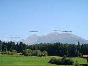
The Kasereck in July 2007 with surrounding peaks (Gumma, Kreuzhöhe) | |
| Highest point | |
| Elevation | 2,740 m (AA) (8,990 ft) |
| Prominence | 425 m ↓ Kaserscharte |
| Isolation | 3.0 km → Hochgolling |
| Coordinates | 47°13′59″N 13°46′00″E / 47.23306°N 13.76667°ECoordinates: 47°13′59″N 13°46′00″E / 47.23306°N 13.76667°E |
| Geography | |
 Kasereck | |
| State/Province | AT-5 |
| Parent range | Schladminger Tauern, Niedere Tauern |
| Climbing | |
| First ascent | Hans Wödl |
| Normal route | Via the Furtriegel along the summit arête (west flank, UIAA I) |
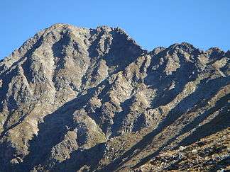 The Kasereck | |
The Kasereck,[1] at 2,740 m (AA), is one of the highest peaks of the Schladming Tauern and thus also the Lower Tauern. It is the most prominent summit on the crest that runs from the Hochgolling southwards and separates the valleys of Göriachtal in the west and Lessachtal in the east. Geographically this mountain lies in Salzburg state and is most easily climbed from Göriach in the Lungau.
Below the mountain nestles the lake of Piendlsee (2,033 m (AA)). The easiest ascent runs from the Göriacher Winkel from the Piendlalm via the Piendlsee and the southwest arête and west flank to the top.
Neighbouring summits
- Kreuzhöhe (2,566 m)
- Kampelfenster (2,557 m)
- Wirriegelhöhe (2,600 m)
- Weißhöhe (2,646 m)
- Hochgolling (2,862 m)
- Hocheck (2,638 m)
- Lesshöhe (2,490 m)
- Gensgitsch (2,279 m)
- Gummaberg (2,315 m)
Gallery
-
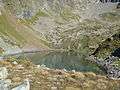
Piendlsee
-

The Kasereck and surrounding peaks - May 2007
References
- ↑ Brandl, Sepp (2010). Nationalpark Hohe Tauern Nord. Bergverlag Rother. p. 156. ISBN 9783763341269. Retrieved 20 February 2016.
This article is issued from Wikipedia - version of the 2/21/2016. The text is available under the Creative Commons Attribution/Share Alike but additional terms may apply for the media files.