Hochgolling
| Hochgolling | |
|---|---|
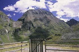 Hochgolling from the south in 1994 | |
| Highest point | |
| Elevation | 2,862 m (9,390 ft) [1] |
| Prominence | 1,124 m (3,688 ft) [1][2] |
| Coordinates | 47°16′00″N 13°45′42″E / 47.26667°N 13.76167°ECoordinates: 47°16′00″N 13°45′42″E / 47.26667°N 13.76167°E |
| Geography | |
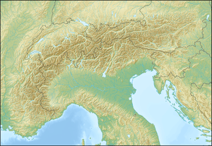 Hochgolling Location in the Alps | |
| Location | Steiermark and Salzburg, Austria |
| Parent range | Lower Tauern |
| Climbing | |
| First ascent | August the 8th 1791, by an unknown alpinist of Tamsweg[3] |
The Hochgolling (2,862 m) is a mountain of the Eastern Alps, located on the border of Steiermark and Salzburg, Austria, near the ski resort of Schladming. It is the highest peak of the Lower Tauern range.
A hiking rather than a climbing peak, the mountain is relatively low by alpine standards, but still towers over all of its neighbours. Its northern face is a 1,200 m high wall, while its other slopes are more gentle. A long ridge slopes south from the summit, dividing the Göriach Valley from the Lessach Valley.
Due to Hochgolling's topographic isolation the views from its summit are panoramic, stretching from the glaciated peaks of the vast High Tauern in the west to the lower Gurktal Alps to the east, and including the Julian Alps, Kamnik Alps and Karawanks to the south.[4]
References
- 1 2 Hochgolling, Austria, on www.peakbagger.com (access: May 2012)
- ↑ Key col:Radstädter Tauern - 1,738 m
- ↑ Peter Holl: Alpenvereinsführer Niedere Tauern, Bergverlag Rudolf Rother, München 1983. ISBN 3-7633-1231-5
- ↑ "Hochgolling - summitpost". summitpost.org. Retrieved 19 February 2016.
External links
- Hochgolling on www.summitpost.org
| Wikimedia Commons has media related to Category:Hochgolling. |