Lower Tauern
| Lower Tauern | |
|---|---|
| Niedere Tauern | |
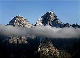
 Hochgolling (2,862 m) | |
| Highest point | |
| Peak | Hochgolling |
| Elevation | 2,863 m (9,393 ft) |
| Coordinates | 47°16′0″N 13°45′42″E / 47.26667°N 13.76167°E |
| Geography | |
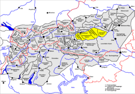 Location within the Eastern Alps | |
| Country | Austria |
| States | Salzburg and Styria |
| Range coordinates | 47°18′N 14°00′E / 47.3°N 14°ECoordinates: 47°18′N 14°00′E / 47.3°N 14°E |
| Parent range | Central Eastern Alps |
| Borders on |
List
|
| Geology | |
| Orogeny | Alpine orogeny |
The Lower Tauern[1][2][3] or Niedere Tauern (Slovene: Nizke Ture) are a mountain range of the Central Eastern Alps, in the Austrian states of Salzburg and Styria.
For the etymology of the name, see Tauern.
Geography
The range forms a part of the main chain of the Alps. The highest peak of the Lower Tauern is the Hochgolling, part of the Schladming Tauern, at 2,863 m (9,393 ft).
Important mountain pass roads include Radstädter Tauern Pass (1,738 m (5,702 ft)), Sölk Pass (1,788 m (5,866 ft)), and Triebener Tauern Pass (1,274 m (4,180 ft)). The range is also crossed by the Tauern Autobahn (A10) through the Tauern Road Tunnel.
Borders
In the west and south the Murtörl mountain pass and the River Mur separate them from the Hohe Tauern mountain range, while in the east and north the River Enns and the Schober Pass marks the border to the Northern Limestone Alps.
Alpine Club classification
According to the Alpine Club classification of the Eastern Alps, the Lower Tauern may be divided into four subgroups (from west to east):
- Radstadt Tauern (45a)
- Schladming Tauern (45b)
- Rottenmann and Wölz Tauern (45c)
- Seckau Tauern (45d).
The four groups listed above (the Radstadt Tauern, Schladming Tauern, Rottenmann and Wölz Tauern and Seckau Alps) are considered Alpine subsections.
Notable summits
Some notable summits of the range are:
| Name | elevation (m) | subsection |
|---|---|---|
| Hochgolling | 2,862 | Schladming Tauern |
| Weißeck | 2,711 | Radstadt Tauern |
| Mosermandl | 2,680 | Radstadt Tauern |
| Hochfeind | 2,687 | Radstadt Tauern |
| Großes Gurpitscheck | 2,526 | Schladming Tauern |
| Hundstein | 2,614 | Schladming Tauern |
| Hochwildstelle | 2,747 | Schladming Tauern |
| Roteck | 2,742 | Schladming Tauern |
| Großer Knallstein | 2,599 | Schladming Tauern |
| Rettlkirchspitze | 2,475 | Rottenmann and Wölz Tauern |
| Großer Bösenstein | 2,425 | Rottenmann and Wölz Tauern |
| Geierhaupt | 2,417 | Seckau Tauern |
| Hochreichhart | 2,416 | Seckau Tauern |
| Seckauer Zinken | 2,389 | Seckau Tauern |
| Maierangerkogel | 2,356 | Seckau Tauern |
Geology and environment
The Lower Tauern mark the approximate eastern limit of the continuous ice sheet in the Alps during the Würm glaciation. Eastern parts of the group were therefore unglaciated, and served as an important refugium for silicicolous plants.
Winter sports
A number of skiing resorts are situated in the Lower Tauern, including Obertauern and Schladming.