Karstädt
Karstädt is a municipality in the Prignitz district, in Brandenburg, Germany.
Demography
Development of Population since 1875 within the Current Boundaries (Blue Line: Population; Dotted Line: Comparison to Population Development of Brandenburg state; Grey Background: Time of Nazi rule; Red Background: Time of Communist rule)
Recent Population Development (Blue Line) and Forecasts
Karstädt:
Population development within the current boundaries (2013)[2]
| Year |
Population |
|---|
| 1875 | 8 338 |
| 1890 | 8 054 |
| 1910 | 8 800 |
| 1925 | 9 172 |
| 1933 | 9 024 |
| 1939 | 8 914 |
| 1946 | 13 676 |
| 1950 | 13 168 |
| 1964 | 10 125 |
| 1971 | 10 012 |
|
|
| Year |
Population |
|---|
| 1981 | 9 480 |
| 1985 | 9 332 |
| 1989 | 9 180 |
| 1990 | 9 015 |
| 1991 | 8 733 |
| 1992 | 8 601 |
| 1993 | 8 551 |
| 1994 | 8 529 |
| 1995 | 8 395 |
| 1996 | 8 243 |
|
|
| Year |
Population |
|---|
| 1997 | 8 160 |
| 1998 | 8 155 |
| 1999 | 7 966 |
| 2000 | 7 808 |
| 2001 | 7 630 |
| 2002 | 7 457 |
| 2003 | 7 323 |
| 2004 | 7 184 |
| 2005 | 7 038 |
| 2006 | 6 872 |
|
|
| Year |
Population |
|---|
| 2007 | 6 750 |
| 2008 | 6 628 |
| 2009 | 6 512 |
| 2010 | 6 376 |
| 2011 | 6 204 |
| 2012 | 6 149 |
| 2013 | 6 057 |
|
|
References


.png)
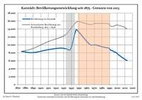 Development of Population since 1875 within the Current Boundaries (Blue Line: Population; Dotted Line: Comparison to Population Development of Brandenburg state; Grey Background: Time of Nazi rule; Red Background: Time of Communist rule)
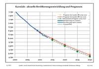 Recent Population Development (Blue Line) and Forecasts