Groß Pankow (Prignitz)
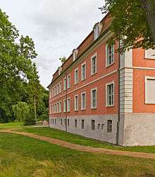
Wolfshagen manor

Church in Boddin

Church in Langnow
Groß Pankow (Prignitz) is a municipality in Prignitz district, Brandenburg, Germany. The municipality was formed in 2001 from the union of municipalities of the former Amt of Groß Pankow/Prignitz and some in Amt Pritzwalk-Land. Amt Groß Pankow/Prignitz was then dissolved.[2]
Groß Pankow is connected via German Federal Highway B 189 to the cities of Pritzwalk, Perleberg, Wittenberge and Magdeburg.
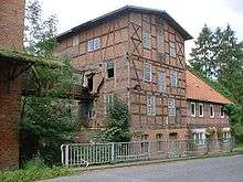
Former mill in Wolfshagen

Wolfshagen manor
Geography
The municipality has 39 villages in 18 districts[3] with the populations given in parentheses (As of March 1, 2010)[4]
- Baek (287)
- Baek (222)
- Strigleben (65)
- Boddin-Langnow (240)
- Boddin (153)
- Heidelberg (30)
- Langnow (57)
- Groß Pankow (587)
- Groß Pankow (551)
- Luggendorf (36)
- Groß Woltersdorf (159)
- Brünkendorf (14)
- Groß Woltersdorf (86)
- Klein Woltersdorf (59)
- Gulow-Steinberg (146)
- Gulow (94)
- Steinberg (52)
- Helle (303)
- Groß Langerwisch (224)
- Helle (45)
- Neudorf (34)
- Kehrberg (260)
- Klein Gottschow (173)
- Guhlsdorf (50)
- Klein Gottschow (89)
- Simonshagen (34)
|
- Kuhbier (213)
- Kuhsdorf (192)
- Bullendorf (58)
- Kuhsdorf (134)
- Lindenberg (271)
- Retzin (275)
- Klein Linde (46)
- Kreuzburg (30)
- Retzin (129)
- Rohlsdorf (70)
- Seddin (113)
- Tacken (97)
- Tangendorf-Hohenvier (120)
- Hohenvier (35)
- Tangendorf (85)
- Tüchen (231)
- Klenzenhof (42)
- Reckenthin (99)
- Tüchen (90)
- Vettin (107)
- Wolfshagen (383)
- Dannhof (43)
- Hellburg (46)
- Horst (43)
- Wolfshagen (251)
|
Demography
-
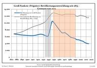
Development of Population since 1875 within the Current Boundaries (Blue Line: Population; Dotted Line: Comparison to Population Development of Brandenburg state; Grey Background: Time of Nazi rule; Red Background: Time of Communist rule)
-
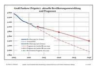
Recent Population Development (Blue Line) and Forecasts
Groß Pankow (Prignitz):
Population development within the current boundaries (2013)[5]
| Year |
Population |
|---|
| 1875 | 6 795 |
| 1890 | 6 478 |
| 1910 | 6 297 |
| 1925 | 6 714 |
| 1933 | 6 362 |
| 1939 | 6 255 |
| 1946 | 10 398 |
| 1950 | 10 034 |
| 1964 | 7 223 |
| 1971 | 7 099 |
|
|
| Year |
Population |
|---|
| 1981 | 5 840 |
| 1985 | 5 665 |
| 1989 | 5 484 |
| 1990 | 5 387 |
| 1991 | 5 257 |
| 1992 | 5 180 |
| 1993 | 5 092 |
| 1994 | 5 091 |
| 1995 | 5 114 |
| 1996 | 5 056 |
|
|
| Year |
Population |
|---|
| 1997 | 5 031 |
| 1998 | 5 002 |
| 1999 | 4 943 |
| 2000 | 4 868 |
| 2001 | 4 790 |
| 2002 | 4 758 |
| 2003 | 4 710 |
| 2004 | 4 671 |
| 2005 | 4 560 |
| 2006 | 4 471 |
|
|
| Year |
Population |
|---|
| 2007 | 4 345 |
| 2008 | 4 243 |
| 2009 | 4 193 |
| 2010 | 4 132 |
| 2011 | 4 063 |
| 2012 | 3 991 |
| 2013 | 3 999 |
|
|
References

_in_PR.png)